The National Geologic Map Database is migrating to a new infrastructure. We apologize for any service disruptions during this process.
|
|---|


- Usage in publication:
-
- Chainman shale*
- Modifications:
-
- Named
- Dominant lithology:
-
- Shale
- AAPG geologic province:
-
- Great Basin province
Summary:
Named for the Chainman mine near Lane in White Pine Co, NV, Great Basin province. No type locality designated. Geologic map. Mapped in southeast, and west-central and northwest parts of quad. Covered by the next younger formation, the Ely limestone (new) in central part of quad. Upper contact is arbitrarily drawn. Overlies Joana limestone (new). Composed of soft, fissile clay shale that grades locally into fine-grained sandy shale. Has much carbonaceous matter. Some cobble-like concretions of iron carbonate locally. One massive 30 ft thick quartzite near middle in northwest part of area. Some gray limestone. Is nearly 1,000 ft thick; differs greatly in thickness from place to place. Upper part is fossiliferous; fossils listed. Assigned to Upper Mississippian.
Source: GNU records (USGS DDS-6; Denver GNULEX).
- Usage in publication:
-
- Chainman shale*
- Modifications:
-
- Areal extent
- AAPG geologic province:
-
- Great Basin province
Summary:
Pg. 69-70. Term Chainman shale extended into Eureka district, Nevada, and applied to basal black, shale of Upper Mississippian sequence where this unit can be separately mapped [mapped in two areas only]. Elsewhere equivalent beds are included in Chainman and Diamond Peak formations undifferentiated. Predominantly black shale with thin interbeds of brown sandstone. Apparent thickness at mouth of Secret Canyon about 5,000 feet. Base not exposed in this western belt, western limit being marked either by igneous rocks or by fault contact with lower Paleozoic rocks. In Windfall Canyon, Permian(?) rocks rest directly on Chainman shale or Diamond Peak formation. Fossils (brachiopods, corals). Brachiopods suggest Late Mississippian age; corals were examined by Helen Duncan who reports that they resemble lower Carboniferous genera.
Source: US geologic names lexicon (USGS Bull. 1200, p. 706-708); supplemental information from GNU records (USGS DDS-6; Menlo GNULEX).
- Usage in publication:
-
- Chainman shale*
- Modifications:
-
- Areal extent
- AAPG geologic province:
-
- Great Basin province
Summary:
Unit geographically extended into southern Inyo Mountains, CA. Table of Paleozoic rocks show Chainman shale is 1000 +/-ft of dark-gray silty shale and phyllite with limestone interbeds. Conformably underlies Keeler Canyon formation (new). Overlies Perdido formation. Age given as Mississippian.
Source: GNU records (USGS DDS-6; Menlo GNULEX).
- Usage in publication:
-
- Chainman shale*
- Modifications:
-
- Areal extent
- AAPG geologic province:
-
- Great Basin province
Summary:
Chainman shale geographically extended into Confusion Range west-central UT where underlies Ely limestone. [In this report Ely limestone replaces Bird Spring formation in Confusion Range.] Age in stratigraphic section given as Mississippian.
Source: GNU records (USGS DDS-6; Menlo GNULEX).
- Usage in publication:
-
- Chainman shale
- Modifications:
-
- Revised
- AAPG geologic province:
-
- Great Basin province
Summary:
Correlation chart shows Chainman shale as upper formation in White Pine Group in Quartz Spring area, northern Panamint Range, Inyo Co, CA. Overlies Peers Spring formation of White Pine Group. Names retained although "these three names have frequently been employed in a synonymous sense." p.110.
Source: GNU records (USGS DDS-6; Menlo GNULEX).
- Usage in publication:
-
- Chainman shale*
- Modifications:
-
- Areal extent
- AAPG geologic province:
-
- Great Basin province
Summary:
Shown on generalized geologic sketch map of southern Diamond Mountains as Mississippian age. Section at 1.5 mi east of Phillipsburg Mine is 4000 ft thick; at north, east, and southeast of Black Point is 3500 ft thick; and at Newark Mountain-Bold Bluff is 2500 ft (variation due to tectonic thickening). Contrast in lithologic character of Chainman shale above and below Bold Bluff thrust fault indicates somewhat coarser facies, deposited near source area, has been thrust over fine-grained facies.
Source: GNU records (USGS DDS-6; Menlo GNULEX).
- Usage in publication:
-
- Chainman Formation
- Modifications:
-
- Revised
- AAPG geologic province:
-
- Great Basin province
Summary:
Correlation chart of northern UT shows that in Silver Island Range Chainman Formation is divided into members (ascending): Diamond Peak, Willow Spring, and Jensen Members. "The Jensen and Willow Spring members will be introduced subsequently." p.251. [Note: Jensen and Willow Gap Limestone Members introduced by Walter Sadlick (1966, PhD thesis) in Dissertation Abstracts v.26 p.5978.]. Correlation chart shows Visean-Namurian (Late Mississippian) boundary.
Source: GNU records (USGS DDS-6; Menlo GNULEX).
- Usage in publication:
-
- Chainman Formation
- Modifications:
-
- Redescribed
- Revised
- Biostratigraphic dating
- AAPG geologic province:
-
- Great Basin province
Summary:
Chainman Formation, about 2000 ft thick along UT-NV border, is subdivided into six named lithostratigraphic members which intertongue with each other (ascending); Needle Siltstone (new), Skunk Spring Limestone (new), Camp Canyon (new), Donner (new), Willow Gap Limestone (new), and Jensen Members. Additionally, Scotty Wash Quartzite is relegated to member status in Chainman Formation and is recognized only in southeastern NV. Seven faunal zones are used for interpreting biostratigraphic analysis of unit which ranges in age from Visean to Namurian [Late Mississippian].
Source: GNU records (USGS DDS-6; Menlo GNULEX).
- Usage in publication:
-
- Chainman Shale*
- Modifications:
-
- Age modified
- AAPG geologic province:
-
- Great Basin province
Summary:
Mapped in Ely 7.5' quad, White Pine Co, NV. Described as dark-olive-gray to black fissile shale containing some interbeds of olive-gray thin platy and thin-bedded detrital fossiliferous limestone and limestone nodules in lower part. Upper part contains yellow and brown lenticular and quartzitic sandstone beds. Thickness is 1500(?) ft. Age shown as Late Mississippian.
Source: GNU records (USGS DDS-6; Menlo GNULEX).
- Usage in publication:
-
- Chainman Shale*
- Modifications:
-
- Not used
- AAPG geologic province:
-
- Great Basin province
Summary:
"Chainman Shale equivalent" and overlying "Tippipah Limestone equivalent" used instead at Indian Springs. Measured section shows Chainman Shale equivalent overlies Monte Cristo Limestone.
Source: GNU records (USGS DDS-6; Menlo GNULEX).
- Usage in publication:
-
- Chainman Shale*
- Modifications:
-
- Areal extent
- AAPG geologic province:
-
- Great Basin province
Summary:
Mapped in Wheeler Peak 15' quad as small outcrop between Johns Wash fault and Murphy Wash fault. In fault contact with overlying Ely Limestone. Also underlies Quaternary and Tertiary rocks. Age shown as Late Mississippian.
Source: GNU records (USGS DDS-6; Menlo GNULEX).
- Usage in publication:
-
- Chainman Shale*
- Modifications:
-
- Areal extent
- Biostratigraphic dating
- AAPG geologic province:
-
- Great Basin province
Summary:
Unit is thickest and best exposed in parts of Lincoln Co, NV, north and west of HWY 93. Complete sections exposed on Dutch John and Grassy Mountains in Egan, Timpahute and Pahranagat Ranges, in Meadow Valley and Delamar Mountains; also in Fairview, Golden Gate and Spotted Ranges, in Worthington Mountains and on Chert Ridge. In east Pahranagat Range unit mapped undivided with overlying Scotty Wash Quartzite. Three informal members are generally recognized; lower siltstone facies, middle black shale facies and upper shale facies--not all facies are present throughout unit. Is Late Mississippian age on basis of fossils (table included) identified by Mackenzie Gordon, Jr. and Helen Duncan.
Source: GNU records (USGS DDS-6; Menlo GNULEX).
- Usage in publication:
-
- Chainman Formation*
- Modifications:
-
- Redescribed
- Biostratigraphic dating
- AAPG geologic province:
-
- Great Basin province
Summary:
Term "formation" is more apt than "shale" for Diamond Peak area. Chainman Formation divided into Water Canyon facies consisting mostly of black shale in southern and southeastern parts of mapped area and Black Point facies consisting mostly of siltstone on west side of range from south of Black Point to northern boundary of quad. Water Canyon facies consists largely of clayrock and clayey siltrock which are commonly carbonaceous and pyritiferous; Black Point facies consists of interbedded siltstone, clayrock sandstone, and conglomerates. Also includes discontinuous intercalations of sandstone and conglomerate. Generalized sections included in report for both facies (Water Canyon facies, 1830 and 2400ft: Black Point facies, 3530ft) which are also shown on geologic map of Diamond Peak area. Faunal evidence though meager points to Meramec age for Chainman Formation in Diamond Peak area.
Source: GNU records (USGS DDS-6; Menlo GNULEX).
- Usage in publication:
-
- Chainman Shale*
- Modifications:
-
- Mapped
- AAPG geologic province:
-
- Great Basin province
Summary:
Mapped in Eureka 15' quad, Eureka and White Pine Cos, NV where unit occurs in Diamond Mountains. Described as black shale with local interbedded brown-weathering sandstone especially in top part. Exhibits slaty or "pencil" cleavage in many places. Is 4000 ft thick. Probably all Meramec in age. Is Late Mississippian age on map.
Source: GNU records (USGS DDS-6; Menlo GNULEX).
- Usage in publication:
-
- Chainman Shale
- Modifications:
-
- Not used
- AAPG geologic province:
-
- Great Basin province
Summary:
"Chainman Shale equivalent" used in Pritchards Station 15' quad, Nye Co, NV. Described as highly fissile black shale. Age given as Late Mississippian in this area.
Source: GNU records (USGS DDS-6; Menlo GNULEX).
- Usage in publication:
-
- Chainman Shale*
- Modifications:
-
- Age modified
- AAPG geologic province:
-
- Great Basin province
Summary:
Shown on geologic map of Paleozoic rocks of Carlin-Pinon Range area, Elko and Eureka Counties, Nevada, as Chainman Shale and as Diamond Peak Formation and Chainman Shale, undivided. Includes beds mapped by Dott (1955) as "White Pine-type shales." Overlies Webb Formation. Underlies and interfingers with Diamond Peak Formation. Measured section, 1,575 feet thick, in NW/4 sec. 18, T. 31 N., R. 53 E., and S/2 sec. 12, T. 31 N., R. 52 E. Age of unit is Early and Late Mississippian (map legend). Report includes list of Early Mississippian (Kinderhookian) fossils collected from the Chainman Shale and the Diamond Peak Formation and Chainman Shale, undivided, identified by Mackenzie Gordon, Jr., and Helen Duncan (table 9, p. A49).
Source: Modified from GNU records (USGS DDS-6; Menlo GNULEX).
- Usage in publication:
-
- Chainman Shale*
- Modifications:
-
- Areal extent
- Revised
- AAPG geologic province:
-
- Great Basin province
Summary:
zzzzzMenlo GNULEX: Needle Siltstone Member of Chainman Shale (Sadlick, 1965) is adopted. Its type locality is at Needle Range locality in eastern UT. Principal reference section is designated at Ledger Canyon in Confusion Range, UT. [Chainman Shale is extended into Needles Range, UT.]
Denver GNULEX: Lower part of Chainman Shale described in Needle Mountains, Millard Co, UT in Great Basin province. Divisible into a lower phosphatic member and overlying Needle Siltstone Member (first published use). The phosphatic member overlies Joana Limestone. Phosphatic hardground present at contact. This lower member is a dark organic-rich starved-basin deposit laid down in the Deseret starved basin west of a westward-prograding carbonate platform beginning in late Tournaisian (Osagean) time. Phosphatic member is composed of phosphorite, phosphatic shale and siltstone, bedded spiculitic and radiolarian chert, chertified phosphorite, and micritic limestone. This lower member is continuous into Deseret Limestone, Little Flat, Woodman, and Deep Creek Formations. Overlying Needle Siltstone Member is a bioturbated distal-flysch unit deposited as a result of lowering of sea level as floods of clastic sediments swept east from the nearly filled trough across a shallow submarine rise. These younger sediments intertongued with and later overwhelmed the starved basin sediments. Of late Tournaisian and early Visean (Osagean and Meramecian) age. Conformably overlain by Skunk Spring Limestone Bed. Cross section. Paleogeographic representations.
Source: GNU records (USGS DDS-6; Menlo GNULEX, Denver GNULEX).
- Usage in publication:
-
- Chainman Shale*
- Modifications:
-
- Revised
- AAPG geologic province:
-
- Great Basin province
Summary:
Needle Siltstone Member (Sadlick, 1965) is adopted as lowermost named member of Chainman Shale. Skunk Spring Limestone Member (Sadlick, 1965) is reduced in rank as Skunk Spring Limestone Bed (13.1 ft thick) at the base of unnamed concretionary shale member. Measured composite stratigraphic section of Chainman Shale in Skunk Spring Canyon areas, Confusion Range, UT, is divided into (ascend- ing): phosphatic member (16.4 ft thick), Needle Siltstone Member (167 ft thick), concretionary shale member (111.5 ft thick), middle member (951 ft thick), Willow Gap Member of Sadlick (1965) (335 ft thick), and Jensen Member of Sad- lick (1965) (190 ft thick). [Note that Willow Gap and Jensen Members of Sadlick (1965) are not adopted]. Camp Canyon Member of Sadlick (1965) is not recognized; its rocks are included in authors' informal middle member. Overlies Joana Limestone; underlies Ely Limestone. Age of phosphatic member is Osagean and Meramecian on basis of conodonts. Needle Siltstone Member and lower part of con- cretionary member are Meramecian age. Upper part of con- cretionary member and overlying members are Chesterian age. Chainman Shale is Early and Late Mississippian age.
Source: GNU records (USGS DDS-6; Denver GNULEX).
- Usage in publication:
-
- Chainman Shale*
- Modifications:
-
- Revised
- AAPG geologic province:
-
- Great Basin province
Summary:
Divided into (ascending order): Delle Phosphatic Member (new) of Osagean and Meramecian age and Needle Siltstone Member of Meramecian age in the Needle Range, Millard Co, UT in Great Basin province. Chainman lies in the foreland basin. Delle was called phosphatic member in earlier reports. Chainman overlies Joana Limestone. Basal contact of Delle is a hardground developed on top of the Joana. Delle also assigned as basal member of Woodman, Deep Creek, Little Flat, and Aspen Range Formations, and of Deseret Limestone and Brazer Dolomite at other localities. Correlation of Chainman with other lithostratigraphic units on the Wasatch uplift and Great Basin province, UT, and in Snake River basin, ID, shown on correlation chart. Areal extent map of Delle and of Chainman.
Source: GNU records (USGS DDS-6; Denver GNULEX).
- Usage in publication:
-
- Chainman Shale*
- Modifications:
-
- Areal extent
- AAPG geologic province:
-
- Great Basin province
Summary:
Unit geographically extended into Ninemile Canyon, Pequop Mountains, Spruce Mountain 4 15' quad, Elko Co, NV as Diamond Peak Formation and Chainman Shale, undivided. Age is Mississippian.
Source: GNU records (USGS DDS-6; Menlo GNULEX).
- Usage in publication:
-
- Chainman Formation*
- Modifications:
-
- Mapped 1:24k
- Dominant lithology:
-
- Shale
- Siltstone
- Limestone
- AAPG geologic province:
-
- Great Basin province
Summary:
Is Mississippian formation mapped as ten units in Mountain Home Range in western Millard Co, southwestern UT (Great Basin province). Overlies Joana Limestone (Osagean and Kinderhookian). Overlain by Ely Limestone (Lower Permian, Pennsylvanian, and Upper Mississippian). Subdivisions mostly follow Sadlick (1965) with addition of two members below his Needle Member. Sandberg and others (1980) have listed conodont zones using Sadlick's subdivisions. Welsh (1979) showed regional correlations. Comprised of (descending): Jensen Member (Chesterian), Willow Gap Limestone Member (Chesterian), Camp Canyon Member (Chesterian and Meramecian), Skunk Spring Limestone Bed (Meramecian), Needle Siltstone Member (Meramecian), and Delle Phosphatic Member (Meramecian and Osagean). Composite thickness as much as 867 m. [See specific units for map unit descriptions.]
Source: GNU records (USGS DDS-6; Denver GNULEX).
- Usage in publication:
-
- Chainman Shale*
- Modifications:
-
- Areal extent
- AAPG geologic province:
-
- Great Basin province
Summary:
Chainman Shale is extended into Toano Range and Goshute Peak area. Described as shale and sandstone with some conglomerate. Locally divided into (ascending); Needle Siltstone Member and limestone of Whitehorse Pass area. Unit overlain by limestone of Morris Basin area locally; in other places it is overlain by Diamond Peak Formation. Overlies Joana Limestone. Age is Mississippian.
Source: GNU records (USGS DDS-6; Menlo GNULEX).

- Usage in publication:
-
- Chainman Formation*
- Modifications:
-
- Mapped 1:24k
- Dominant lithology:
-
- Siltstone
- Limestone
- Shale
- AAPG geologic province:
-
- Great Basin province
Summary:
Is Mississippian formation mapped as nine units in southern part of Mountain Home Range in western Millard and Beaver Cos, southwestern UT (Great Basin province). Overlies Joana Limestone (Osagean and Kinderhookian). Overlain by Ely Limestone (Lower Permian, Pennsylvanian, and Upper Mississippian). Subdivisions mostly follow Sadlick (1965, 1966) with addition of Delle Phosphatic Member (Sandberg and Gutschick, 1984) at base of formation. Sandberg and others (1980) have listed Chainman conodont zones using Sadlick's subdivisions. Comprised of (descending): Jensen Member (Chesterian), Willow Gap Limestone Member (Chesterian), Camp Canyon Member (Chesterian and Meramecian), Skunk Spring Limestone Member (Meramecian), Needle Siltstone Member (Meramecian), and Delle Phosphatic Member (Meramecian and Osagean). Composite thickness as much as 792 m. [See specific units for map unit descriptions.]
Source: GNU records (USGS DDS-6; Denver GNULEX).
- Usage in publication:
-
- Chainman Shale*
- Modifications:
-
- Areal extent
- AAPG geologic province:
-
- Great Basin province
Summary:
Unit geographically extended into area of report (Meadow Valley Mountains). Age given as Mississippian.
Source: GNU records (USGS DDS-6; Menlo GNULEX).
- Usage in publication:
-
- Chainman Shale*
- Modifications:
-
- Areal extent
- AAPG geologic province:
-
- Great Basin province
Summary:
(advance copy). Unit geographically extended into report area, in Jumbled Hills, Pahranagat area, southern Nevada, as Scotty Wash Quartzite and Chainman Shale, undivided. Age is Mississippian.
Source: GNU records (USGS DDS-6; Menlo GNULEX).
- Usage in publication:
-
- Chainman Shale*
- Modifications:
-
- Areal extent
- AAPG geologic province:
-
- Great Basin province
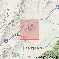
Summary:
Unit geographically extended into report area (Elko Hills, Elko Co, NV). Age given as Mississippian.
Source: GNU records (USGS DDS-6; Menlo GNULEX).
- Usage in publication:
-
- Chainman Shale*
- Modifications:
-
- Areal extent
- AAPG geologic province:
-
- Great Basin province
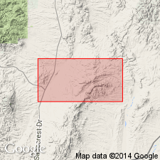
Summary:
Unit geographically extended into report area (northern Adobe Range, Elko Co. NV). Age given as Mississippian here.
Source: GNU records (USGS DDS-6; Menlo GNULEX).
- Usage in publication:
-
- Chainman Shale*
- Modifications:
-
- Areal extent
- AAPG geologic province:
-
- Great Basin province
Summary:
Unit geographically extended into area of report (Crater Island of Silver Island Mountains) as the "undivided Chainman Shale and Diamond Peak Formation." Age for the undivided unit given as Late Mississippian and Early Pennsylvanian.
Source: GNU records (USGS DDS-6; Menlo GNULEX).
- Usage in publication:
-
- Chainman Shale*
- Modifications:
-
- Areal extent
- AAPG geologic province:
-
- Great Basin province
Summary:
Unit extended into report area (southern Silver Island Mountains) as Chainman Shale and Diamond Peak Formation, undivided. Age is Mississippian.
Source: GNU records (USGS DDS-6; Menlo GNULEX).
- Usage in publication:
-
- Chainman Shale*
- Modifications:
-
- Areal extent
- AAPG geologic province:
-
- Great Basin province
Summary:
Unit geographically extended into report area (southern Sheep Range, Fossil Ridge, and Castle Rock area, Clark Co, NV). Age given as Late Mississippian.
Source: GNU records (USGS DDS-6; Menlo GNULEX).
- Usage in publication:
-
- Chainman Shale*
- Modifications:
-
- Areal extent
- AAPG geologic province:
-
- Great Basin province
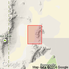
Summary:
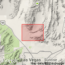
Chainman Shale extended into report area [northern Pilot Range, Patterson Pass 7.5 quad] as part of undivided unit. Age shown as Mississippian.
Source: GNU records (USGS DDS-6; Menlo GNULEX).
- Usage in publication:
-
- Chainman Shale*
- Modifications:
-
- Areal extent
- AAPG geologic province:
-
- Great Basin province
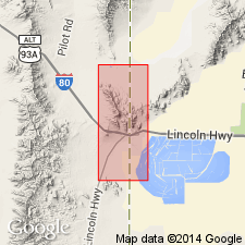
Summary:
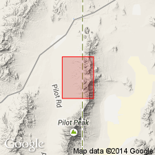
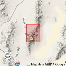
Chainman Shale is geographically extended into report area [northern Pilot Range, Crater Island NW 7.5' quad, Box Elder Co, UT] as part of undivided unit. Age shown as Mississippian.
Source: GNU records (USGS DDS-6; Menlo GNULEX).
- Usage in publication:
-
- Chainman Shale*
- Modifications:
-
- Areal extent
- AAPG geologic province:
-
- Great Basin province
Summary:
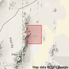
Chainman Shale geographically extended into report area [south Pilot Range] as part of undivided unit. Age is given as Mississippian.
Source: GNU records (USGS DDS-6; Menlo GNULEX).
For more information, please contact Nancy Stamm, Geologic Names Committee Secretary.
Asterisk (*) indicates published by U.S. Geological Survey authors.
"No current usage" (†) implies that a name has been abandoned or has fallen into disuse. Former usage and, if known, replacement name given in parentheses ( ).
Slash (/) indicates name conflicts with nomenclatural guidelines (CSN, 1933; ACSN, 1961, 1970; NACSN, 1983, 2005, 2021). May be explained within brackets ([ ]).