

- Usage in publication:
-
- Hensley Member*
- Modifications:
-
- Original reference
- Dominant lithology:
-
- Sandstone
- Shale
- Coal
- AAPG geologic province:
-
- Appalachian basin
Summary:
Pg. B30-B38. Hensley Member of Lee Formation. Name applied to nonresistant beds of the Lee that lie between top of Middlesboro Member (new) and base of Bee Rock Sandstone Member and have been referred to as sandstone and shale member D (Englund and others, 1963). Consists mostly of shale in lower, middle, and upper parts with very fine- to medium-grained, thin- to thick-bedded sandstones in between. Contains Tunnel coal bed near top. Thickness 320 to 400 feet. Basal contact conformable and placed where conglomeratic quartzose sandstone of Middlesboro Member is succeeded by shale and thin-bedded nonconglomeratic sandstone.
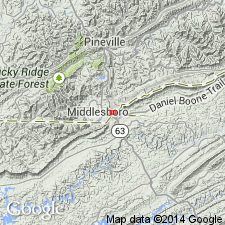
Type section: exposed along Skyland Road and U.S. Highway 25E [now along Pinnacle Road and Route 988, Old Wilderness Road] on northwest side of Cumberland Gap, [approx. Lat. 36 deg. 36 min. 40 sec. N., Long. 83 deg. 40 min. 40 sec. W., Middlesboro South 7.5-min quadrangle, 1959 ed.], Bell Co., southeastern KY. Named from Hensley Flats, and upland area between the crests of Brush and Cumberland Mountains [Varilla 7.5-min quadrangle, Bell Co., southeastern KY].
[Additional locality information from USGS historical topographic map collection TopoView and USGS National Map; accessed Halloween 2013.]
Source: US geologic names lexicon (USGS Bull. 1350, p. 329-330).
- Usage in publication:
-
- Hensley Member*
- Modifications:
-
- Areal extent
- AAPG geologic province:
-
- Appalachian basin
Summary:
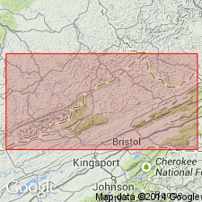
Hensley Member of Lee Formation extended from KY into southwestern VA. Member occurs in several sections in Lee and Wise Cos. Northeastward from central Wise Co., strata equivalent to Hensley are included in Norton Formation.
Source: GNU records (USGS DDS-6; Reston GNULEX).
- Usage in publication:
-
- Hensley Member*
- Modifications:
-
- Age modified
- Areal extent
- AAPG geologic province:
-
- Appalachian basin
Summary:
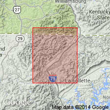
Hensley Member extended from KY to TN as shown in Jellico West quad (plate 2 of report). Age is refined to Early Pennsylvanian as shown on correlation chart for plate 2.
Source: GNU records (USGS DDS-6; Reston GNULEX).
- Usage in publication:
-
- Hensley Member*
- Modifications:
-
- Areal extent
- AAPG geologic province:
-
- Appalachian basin
Summary:
Hensley Member lies between underlying Middlesboro Member and overlying Bee Rock or Naese Sandstone Members. Hensley was called sandstone and shale member D of Englund and others (1964). In northeastern part of Pine Mountain, Hensley is unnamed map unit composed of shale, siltstone, and sandstone that lies between middle and upper members of Lee Formation of Alvord (1971). In some quads, it is included in upper part of middle member of Lee Formation (Rice, 1973). To the southwest, Hensley is mapped in some areas of TN adjacent to KY (Englund, 1968). Is probably equivalent in the nomenclature of Tennessee Division of Geology to the sequence of shale, siltstone, and sandstone that overlies Sewanee Conglomerate or Newton Sandstone and underlies Rockcastle Conglomerate. Age is Early Pennsylvanian.
Source: GNU records (USGS DDS-6; Reston GNULEX).

- Usage in publication:
-
- Hensley Member
- Modifications:
-
- Revised
- AAPG geologic province:
-
- Appalachian basin
Summary:
Breathitt Formation is informally elevated to group rank and subdivided into the following eight informal formations: Pocahontas, Bottom Creek, Alvy Creek, Grundy, Pikeville, Hyden, Four Corners, and Princess formations. Hensley Member is assigned in this report to the Alvy Creek formation as a lateral equivalent of the Coal Cliff member (informally named) and shale member A, also of the Alvy Creek. [Revisions made in this paper are strongly contested by C. Rice and other USGS scientists who work in this area (oral commun., 9/3/93).]
Source: GNU records (USGS DDS-6; Reston GNULEX).

- Usage in publication:
-
- Hensley Member
- Modifications:
-
- Revised
- AAPG geologic province:
-
- Appalachian basin
Summary:
The Hensley Member, mapped along Pine and Cumberland Mountain in KY contains shales, siltstones, sandstones, and coal beds typical of the Breathitt, formally raised to group rank in this report. Regional studies show that the underlying Bee Rock Sandstone and the overlying Sewanee Sandstone, here assigned to Breathitt, pinch out in the subsurface, and the Hensley is laterally equivalent to the coal-bearing rocks of the Alvy Creek formation (informally named) in VA and WV. Therefore, the Hensley is removed from the Lee Formation and reassigned to the Alvy Creek. The Lee Formation is dropped from usage. Any quartzose sandstone that has been locally mapped as part of the Hensley should be considered part of the adjacent Sewanee or Bee Rock or as unnamed units within the Hensley. Strata between the Paragon Formation and the Rockcastle Sandstone Member of the Bee Rock Sandstone along the western belt of outcrop in KY, previously mapped as part of the lower tongue of the Breathitt, are here referred to the Hensley Member. According to the author, formal nomenclature presented in this report for units occurring in KY has been accepted by the Kentucky Stratigraphic Nomenclature Committee. Units that occur largely outside KY are considered informal. Report includes correlation charts, cross sections, and measured sections.
Source: GNU records (USGS DDS-6; Reston GNULEX).

- Usage in publication:
-
- Hensley Member
- Modifications:
-
- Areal extent
- AAPG geologic province:
-
- Appalachian basin
Summary:
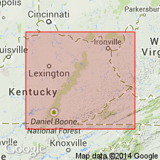
Hensley Member is restricted to extreme northwestern Buchanan Co., northwestern Dickenson Co., and central and western Wise Co. Crops out along Pine Mountain and along Stone Mountain from Ramsey to Cumberland Gap. In the subsurface it is between 120 and 580 ft in thickness, thinning to the northwest. Consists mostly of shale, siltstone, and thin-bedded lithic sandstone, but may contain resistant beds of light gray quartzarenite and conglomeratic sandstone. Coal beds and underclay are also present and include the Upper Seaboard, Tiller, Jawbone, and Raven coal beds or zones. Contact with the underlying Middlesboro Member is abrupt but conformable. Unconformably underlies the Bee Rock Sandstone Member. Where the Bee Rock is absent, the rocks of the Hensley Member are included in the Norton Formation. Age is Early Pennsylvanian (Morrowan).
Source: GNU records (USGS DDS-6; Reston GNULEX).

- Usage in publication:
-
- Hensley Member*
- Modifications:
-
- Areal extent
- AAPG geologic province:
-
- Appalachian basin
Summary:
Hensley Member of Lee Formation. [Mostly shale, siltstone, and thin-bedded sandstone up to 450 feet thick], in middle part of Lee Formation below Bee Rock Sandstone Member and above Middlesboro Member. Includes Tunnel (or Raven) coal bed. Age is Early Pennsylvanian.
Recognized in Upper Cumberland River district, southeastern KY.
[See also Rice and others, 1994, GSA Spec. Paper 294, p. 129.]
Source: Publication.

- Usage in publication:
-
- Hensley Member
- Modifications:
-
- Areal extent
- AAPG geologic province:
-
- Appalachian basin
Summary:
Corr. chart. Hensley Member of Alvy Creek formation (informal) of Breathitt Group (KY); Hensley Member of Lee Formation (VA). Sandstone, siltstone, shale, and/or mudstone. Age is Early Pennsylvanian (Westphalian; Morrowan).
[In most of] eastern and southeastern Kentucky it comprises entire Alvy formation. In eastern Kentucky [Southwestern district] includes Stearns No. 1 through No. 3 coal zones; in southeastern Kentucky [Upper Cumberland River district] includes the Tunnel (Raven) coal bed. Lies below Bee Rock Sandstone and above Sewanee Sandstone, both of Breathitt Group.
In southwestern Virginia is up to 450 feet thick, in middle of Lee Formation below Bee Rock Sandstone Member and above Middlesboro Member; interbedded with lower part of Norton Formation. Equivalent to Council Sandstone Member of New River Formation of southwestern Virginia and Whitwell Shale of Crab Orchard Mountains Group of Tennessee.
[Eble and others (2009, Kentucky Geol. Survey, ser. XII, Spec. Pub. 10, figs. 5.2, 5.3) placed beds approx. = Hensley (btw. Bradshaw and Castle coal beds) in middle part of Langsettian (middle part of Westphalian A) on basis of miospores.]
[See also Chesnut, 1997 (revised Oct. 12, 1999), Stratigraphy of the coal-bearing strata of the Eastern Kentucky coal field, available online through the Kentucky Geol. Survey (http://www.uky.edu/KGS/coal/coalcorrel.htm) and geologic descriptions of stratigraphic units in the Kentucky Geological Survey database (http://kgs.uky.edu/kgsmap/KGSLitho/lithoSearch.asp#).]
Source: Publication.
For more information, please contact Nancy Stamm, Geologic Names Committee Secretary.
Asterisk (*) indicates published by U.S. Geological Survey authors.
"No current usage" (†) implies that a name has been abandoned or has fallen into disuse. Former usage and, if known, replacement name given in parentheses ( ).
Slash (/) indicates name conflicts with nomenclatural guidelines (CSN, 1933; ACSN, 1961, 1970; NACSN, 1983, 2005, 2021). May be explained within brackets ([ ]).