The National Geologic Map Database is migrating to a new infrastructure. We apologize for any service disruptions during this process.
|
|---|


- Usage in publication:
-
- Colorado group
- Modifications:
-
- Revised
- AAPG geologic province:
-
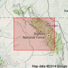
- Bighorn basin
Summary:
Divided in the Basin-Greybull area, Bighorn Co., WY, Bighorn basin into the Benton Shale and the overlying Basin shale (new). Benton divided (ascending) into: "Lower Benton shale member," Peay sandstone member (new), "Upper Benton shale member," and Torchlight sandstone member (new). Benton disconformably overlies Cloverly sandstone. Basin underlies Pierre shale of Montana group. Geologic map Stratigraphic table. Of Late Cretaceous age.
Source: GNU records (USGS DDS-6; Denver GNULEX).
- Usage in publication:
-
- Colorado shale*
- Modifications:
-
- Revised
- AAPG geologic province:
-
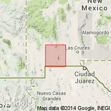
- Basin-and-Range province
Summary:
Revised in that it is now underlain by the newly named Sarten sandstone (which contains fauna of Washita group, Comanche series--Early Cretaceous age) in report area, Luna Co, NM in Basin-and-Range province. At four localities south, southwest, and east of Cooks Peak and 1/2 mi south of the 55 ranch, the Sarten sandstone is overlain by Colorado shale without discordance or other evidence of unconformity to represent the long interval between Washita and Colorado time. Colorado shale is of Late Cretaceous age. Geologic map.
Source: GNU records (USGS DDS-6; Denver GNULEX).
- Usage in publication:
-
- Colorado group*
- Modifications:
-
- Revised
- Areal extent
- AAPG geologic province:
-
- Bighorn basin
Summary:
Raised in stratigraphic rank in the Basin oil field in Big Horn Co, WY, Bighorn basin, from Colorado shale to Colorado group. Overlies Cloverly formation. Underlies Mesaverde formation of Montana group. Divided into (ascending): Thermopolis shale (new), Mowry shale (raised in rank from member), Frontier formation (extended into area from southwest WY), and Cody shale (new). Is about 4,795 ft thick. History of nomenclature chart. Cretaceous age.
Source: GNU records (USGS DDS-6; Denver GNULEX).
- Usage in publication:
-
- Colorado shale*
- Modifications:
-
- Revised
- Areal extent
- AAPG geologic province:
-
- Basin-and-Range province
Summary:
Colorado shale revised--lower contact changed. In report area, Silver City quad, Grant Co, NM in Basin-and-Range province Colorado shale overlies newly named Beartooth quartzite of Cretaceous age. Contact is easily recognized because the quartzite is highly resistant. The top of the Colorado shale is a surface of erosion, and the full sequence of beds is therefore never present in this area. The largest area of the formation in the quad lies between the range near Silver City, with its northwestern outliers on the west, and a line passing roughly northeast through Fort Bayard on the east. Colorado occurs in the Little Burro Mountains, at Lone Mountain, in a small area 2 mi east of Central, and in areas both east and west of Santa Rita. The formation is soft and breaks down easily; therefore forms no salient topographic features. In the region of greatest development northeast of Silver City, it is cut by countless dikes that form a network of low ridges separated by shale valleys. Fossils found 100 to 300 ft above base of the formation indicate that it is part of the early Late Cretaceous, equivalent of the Benton shale of Colorado group. Beds higher in the section may be equivalent to upper part of Mancos shale, and they may include some strata of Montana age. Is of Cretaceous age. Measured section. Geologic map.
Source: GNU records (USGS DDS-6; Denver GNULEX).
- Usage in publication:
-
- Colorado shale*
- Modifications:
-
- Revised
- AAPG geologic province:
-
- Central Montana uplift
Summary:
Mapped (geologic map) in the Musselshell Valley, Meagher and Sweetgrass Cos, MT on the Central Montana uplift. Divided into three mapped units by the newly named Big Elk sandstone member. Overlies the Kootenai formation. Underlies Eagle sandstone. Is chiefly a black shale with calcareous and ferruginous concretions and sandstone that may be conglomeratic, thin-bedded. Two sections measured. One in SE1/4, T11N, R24E and sec 12, T10N, R21E is 2,204 ft thick and includes the Mowry shale member. The second on south side of Shawmut anticline and Big Elk dome is 2,207 ft thick and includes the newly named Big Elk.
Source: GNU records (USGS DDS-6; Denver GNULEX).
- Usage in publication:
-
- Colorado shale*
- Modifications:
-
- Revised
- AAPG geologic province:
-
- Sweetgrass arch
Summary:
Is a sequence of blue-gray to black shale that has a number of gray sandstone beds in the lower third. Is about 1,800 ft thick. Overlies Kootenai formation and underlies Virgelle sandstone. Divided into Blackleaf sandy member (new) at base, and upper unnamed part. Extends in a north-south belt on western part of map area. Is a marine deposit. To east the Colorado group has limy beds called Niobrara formation and the remainder called Benton shale. Limy phase never deposited in western Montana, so sequence called Colorado shale. Fossil list given. Assigned to Late Cretaceous. Geologic map.
Source: GNU records (USGS DDS-6; Denver GNULEX).
- Usage in publication:
-
- Colorado group*
- Modifications:
-
- Areal extent
- AAPG geologic province:
-
- Williston basin
Summary:
Name extended to Black Hills region, Butte and Meade Cos, SD in Williston basin to include (ascending): Graneros shale, Greenhorn limestone, Carlile shale, and Niobrara formation. Use of Benton group discontinued. Late Cretaceous in age.
Source: GNU records (USGS DDS-6; Denver GNULEX).
- Usage in publication:
-
- Colorado shale
- Modifications:
-
- Revised
- AAPG geologic province:
-
- Williston basin
Summary:
Is the oldest unit exposed in the Cat Creek field, Fergus [now Petroleum Co] and Garfield Cos, MT in the Williston basin. Is about 1,924 ft thick and consists of black shale and some thin sandstones near the middle of the formation. The sandstones increase in number and thickness toward the west. Some beds are limy and that lithology occurs as secondary concretions and in clay bands. Two of the sandstones near the middle are named; the older sandstone is named Mosby sandstone member. The Mosby is 3 to 4 ft thick and occurs 1,065 ft above the base of the formation. The overlying 335 ft is named Sage Hen Member. Colorado underlies Eagle sandstone and is underlain in the subsurface by the Kootenai formation. Composite section described. Geologic map. Of Late Cretaceous age.
Source: GNU records (USGS DDS-6; Denver GNULEX).
- Usage in publication:
-
- Colorado group*
- Modifications:
-
- Revised
- AAPG geologic province:
-
- Powder River basin
- Williston basin
- Chadron arch
Summary:
Lower boundary revised upward to exclude Skull Creek shale and Newcastle sandstone in northern Great Plains [Black Hills region in Powder River and Williston basins and on Chadron arch]. Includes (ascending): Mowry shale, Belle Fourche shale, Greenhorn formation, Carlile shale, and Niobrara formation. Late Cretaceous in age.
Source: GNU records (USGS DDS-6; Denver GNULEX).
- Usage in publication:
-
- Colorado formation*
- Modifications:
-
- Mapped 1:31k (Clancy and Devils Fence quads, Jefferson and Broadwater Cos, MT)
- Revised
- Dominant lithology:
-
- Shale
- Mudstone
- Sandstone
- AAPG geologic province:
-
- Montana folded belt
Summary:
Is Lower and Upper Cretaceous formation mapped in east-central Jefferson and west-central Broadwater Cos, MT (Montana folded belt province). Area mapped is south half of Clancy and north half of Devils Fence quads. Outcrops in eastern and southern parts of Clancy and north-central part of Devils Fence half-quads. Divided into three separately mapped units: lower black shale, middle siliceous mudstone and sandstone, and upper black shale. Lower unit is a basal tan-weathering quartz sandstone, drab and olive-gray blocky siltstone, very dark gray to black shale, and an upper dark-gray carbonaceous, limonitic speckled to mottled sandstone. Middle unit is an intertongued marine and nonmarine sandstone, mudstone, and siliceous mudstone, in part volcanic. Upper unit is a very dark gray to black fissile shale with interbedded dark-gray fine-grained sandstone and siltstone in lower part; shale contains sparse concretions of dense limestone and grades into overlying newly named Slim Sam formation (Upper Cretaceous). Overlies Kootenai formation (Lower Cretaceous) with erosional unconformity. Correlation chart. Footnote (p. 26) states that Cobban, Reeside (1952, GSA Bull, p. 1011-1044) recommend Upper-Lower Cretaceous boundary be placed at top of Mowry formation and Colorado be restricted to Upper Cretaceous. However, common usage in western MT is to include rocks from top of Kootenai (Aptian) to top of Niobrara equivalent (Coniacian) in Colorado.
Source: GNU records (USGS DDS-6; Denver GNULEX).
- Usage in publication:
-
- Colorado shale*
- Modifications:
-
- Revised
- AAPG geologic province:
-
- Central Montana uplift
- Montana folded belt
Summary:
Divided in Central Montana uplift and Montana folded belt province into 10 units: 1) basal 30 ft gray marine shale; 2) thin-bedded, flaggy sandstone 30 ft thick; 3) 285 ft mostly shale; 4) gray to white sandstone 20 ft thick that makes a conspicuous ledge; 5) 330 ft of gray shale; 6) 115 ft sandy shale; 7) Boulder River sandstone member (new), 100 ft thick resistant, ridge-forming sandstone; 8) 290 ft thin-bedded sandstone with cherty layers; 9) 225 ft sandstone and shale; and 10) covered interval at least 1,500 ft thick probably mostly shale. Rests on Kootenai formation. Underlies Virgille sandstone. Of Late Cretaceous age. Contains ammonites of Mowry (Albian) age in Boulder River and of Niobrara age in rocks just beneath the Virgille. Geologic map. Columnar sections.
Source: GNU records (USGS DDS-6; Denver GNULEX).
- Usage in publication:
-
- Colorado group*
- Modifications:
-
- Revised
- AAPG geologic province:
-
- Sweetgrass arch
Summary:
Raised in rank in Sweetgrass arch area MT from Colorado shale to Colorado group. Divided into Blackleaf formation (base) and Marias River shale (new, at top). Blackleaf divided into the Flood (base), Taft Hill glauconitic, Vaughn bentonitic, and Bootlegger (top) members, all newly named. Marias River divided into Floweree (base), Cone calcareous, Ferdig shale, and Kevin shale (top) members, all newly named. Overlies Kootenai formation unconformably. Underlies Telegraph Creek formation. Ranges from 1,600-1,800 ft thick. Ranges from Early Cretaceous, Albian Blackleaf to Late Cretaceous, late Cenomanian to early Santonian Marias River shale. Correlation chart.
Source: GNU records (USGS DDS-6; Denver GNULEX).
- Usage in publication:
-
- Colorado group
- Modifications:
-
- Revised
- AAPG geologic province:
-
- Montana folded belt
Summary:
Ranges from 9,170 to 11,500 ft thick sequence of Early and Late Cretaceous age above the Kootenai formation and below Elkhorn Mountains volcanics. Is six to seven times thicker than equivalent strata in Disturbed Belt to east of Rocky Mountain front near Great Falls. Also this sequence contains more coarse-grained strata than equivalent rocks of Disturbed Belt. Due to facies changes not all Disturbed Belt nomenclature applicable in study area. Divided into Blackleaf formation, at base, Coberly formation (new), Jens formation (new), and Carter Creek formation (new), at top. Blackleaf divided into Flood member (base), Taft Hill member and Dunkleberg member (new, at top). Of Early and Late Cretaceous age.
Source: GNU records (USGS DDS-6; Denver GNULEX).
- Usage in publication:
-
- Colorado Shale
- Modifications:
-
- Not used
Summary:
Term Colorado Shale not used in Livingston area, Park Co, MT, Montana folded belt province. Rocks between Kootenai and Telegraph Creek Formations in Livingston area include Thermopolis Shale, Mowry Shale, Frontier Formation, and Cody Shale.
Source: GNU records (USGS DDS-6; Denver GNULEX).
- Usage in publication:
-
- Colorado Shale*
- Modifications:
-
- Mapped 1:24k (Maudlow quad, Gallatin Co, MT)
- Dominant lithology:
-
- Shale
- Mudstone
- Sandstone
- AAPG geologic province:
-
- Montana folded belt
Summary:
Is Lower and Upper Cretaceous formation mapped in northern Gallatin Co, MT (Montana folded belt province). Outcrops in southern two-thirds of quad. Divided into separately mapped lower, middle, and upper units. Lower unit is 550-660 ft of shaly mudstone and porcelanite interbedded with sandstone, greenish gray, medium to very coarse grained, conglomeratic in places, thin-bedded; basal quartzitic sandstone; tentatively correlated with Mowry and Thermopolis Shales. Middle unit, 600-900 ft of sandstone, light-gray to yellowish-brown, fine- to coarse-grained, quartzose, lithic, calcareous or argillaceous, salt-and-pepper appearance, thin- to medium-bedded, ridge-forming; interbedded with dark-gray fine-grained quartzite, gray siliceous mudstone, shale, chert-pebble conglomerate, siliceous limestone, and fossil oysters; INOCERAMUS shells; tentatively correlated with Frontier Formation. Upper unit, 1000 ft of shale and mudstone, gray, some with orange ironstone nodules and cone-in-cone structures, interbedded with sandstone and siltstone, greenish gray, fine grained, quartzose, lithic, glauconitic, calcareous, argillaceous, thin bedded, cross-bedded, fossiliferous; sandstone forms ledges; contains SCAPHITES VENTRICOSUS and SCAPHITES DEPRESSUS ammonite zones of Eldridge Creek Member of Cody Shale. Conformably overlies Kootenai Formation (Lower Cretaceous); conformably underlies Telegraph Creek Formation (Upper Cretaceous).
Source: GNU records (USGS DDS-6; Denver GNULEX).

- Usage in publication:
-
- Colorado Formation*
- Modifications:
-
- Overview
- AAPG geologic province:
-
- Basin-and-Range province
Summary:
Is formation in Silver City-Santa Rita area, NM in Basin-and-Range province. Overlies Beartooth Quartzite (or probable equivalents of earliest Late Cretaceous age or possibly of latest Early Cretaceous age) with apparent conformity, and overlies Paleozoic or Precambrian rocks unconformably. Is correlated, in part, with Pinkard Formation (Cenomanian and Turonian) and equivalent strata in Morenci to Christmas area, AZ in Basin-and-Range province. Is correlated with Graneros Shale and Greenhorn Limestone in northeastern NM and CO. Chiefly of shallow-water marine origin but includes some continental coastal-plain and lagoonal sediments. Colorado and Pinkard are distinctly different in lithology from any Cretaceous strata farther south in southeastern AZ and probably have no age equivalents there; apparently represent rocks near southwestern wedge edge of thick Upper Cretaceous sequence of western interior of North America with little relation to Cretaceous rocks farther south. Marine fossils and stratigraphic position indicate a Cenomanian and Turonian (early Late Cretaceous) age.
Source: GNU records (USGS DDS-6; Denver GNULEX).
- Usage in publication:
-
- Colorado Group*
- Modifications:
-
- Overview
- AAPG geologic province:
-
- Montana folded belt
Summary:
Comprised of two formations in eastern Lewis and Clark Co, MT in Montana folded belt province. Includes Blackleaf Formation (not exposed) and Marias River Shale (component units mapped). Age is Early and Late Cretaceous.
Source: GNU records (USGS DDS-6; Denver GNULEX).
- Usage in publication:
-
- Colorado Group*
- Modifications:
-
- Mapped 1:24k (Wolf Creek quad, Lewis and Clark Co, MT)
- Dominant lithology:
-
- Shale
- Siltstone
- Sandstone
- AAPG geologic province:
-
- Montana folded belt
Summary:
Is Lower and Upper Cretaceous group consisting of (ascending) Blackleaf Formation (Lower Cretaceous) and Marias River Shale (Upper Cretaceous) which are mapped in east-central Lewis and Clark Co, MT (Montana folded belt province). [Blackleaf and Marias River Shale of Colorado Group also mapped or shown in cross sections by Schmidt in adjacent quads (Roberts Mountain quad, GQ-977; Comb Rock quad, GQ-976; and Coburn Mountain quad, GQ-975). Schmidt (1963) mapped Blackleaf and Marias River (Colorado Group not used) in Hogan 4 Southeast quadrangle (I-379) which preceded Wolf Creek quad.] Blackleaf is divided into three separately mapped units (ascending): Flood, Taft Hill, and Vaughn Members. Marias River is divided into four separately mapped units (ascending): Cone Calcareous and Floweree Shale Members, Ferdig Shale Member, sandstone member and Ferdig Shale Member, and Kevin Shale Member. Colorado consists primarily of shale, siltstone, sandstone. Blackleaf is about 765 ft thick; Marias River is about 675 ft thick. Blackleaf unconformably overlies Kootenai Formation (Lower Cretaceous) and unconformably underlies Marias River. Marias River conformably underlies Telegraph Creek Formation (Upper Cretaceous).
Source: GNU records (USGS DDS-6; Denver GNULEX).
- Usage in publication:
-
- Colorado Shale*
- Modifications:
-
- Biostratigraphic dating
- Geochronologic dating
- AAPG geologic province:
-
- Sweetgrass arch
Summary:
Colorado Shale. Samples collected from:
(1) a micaceous bentonite bed near base of SCAPHITES PREVENTRICOSUS ammonite zone, in "Upper horizon," 152 m below top of Colorado Shale, in SW/4 NE/4 sec. 20, T. 31 N., R. 2 W., Toole Co., MT (Sweetgrass arch). K-Ar age on biotite 86.8 Ma (weighted mean). Age is Late Cretaceous (Coniacian).
(2) a 10-m-thick bentonite bed, bracketed by the NEOGASTROPLITES CORNUTUS ammonite zone, in "Lower horizon," Arrow Creek Member of Colorado Shale, in SE/4 NW/4 sec. 17, T. 18 N., R. 10 E., Judith Basin Co., MT (Sweetgrass arch). K-Ar age on biotite-sanidine pair 95.3 +/-1.0 Ma (weighted mean). Age is Early Cretaceous (Albian).
Source: Modified from GNU records (USGS DDS-6; Denver GNULEX).
- Usage in publication:
-
- Colorado Group*
- Modifications:
-
- Overview
- AAPG geologic province:
-
- Sweetgrass arch
Summary:
Divided into Blackleaf Formation (Early and Late Cretaceous, or late Albian to early Cenomanian age) and Marias River Shale (Late Cretaceous, or Cenomanian, Turonian, Coniacian, and Santonian age). Report area includes parts of Toole, Pondera, Chouteau, Teton, Lewis and Clark, and Cascade Cos, MT on the Sweetgrass arch. Lithologic terms removed from all named members of Bootlegger and Marias River. Reference sections designated for Flood, Taft Hill, and Vaughn Members of Blackleaf. Measured sections for all members of Blackleaf and Marias River.
Source: GNU records (USGS DDS-6; Denver GNULEX).
- Usage in publication:
-
- Colorado Formation*
- Modifications:
-
- Biostratigraphic dating
- AAPG geologic province:
-
- Basin-and-Range province
Summary:
Fossil mollusks collected by authors from a 1.5-m sandstone bed at base are of late Cenomanian, Late Cretaceous age. The age of the basal bed is about the same age as assigned to basal part of Greenhorn Formation of the Great Plains area--or DUNVEGANOCERAS PONDI Zone. Luna Co, NM is in the Basin-and-Range province.
Source: GNU records (USGS DDS-6; Denver GNULEX).
- Usage in publication:
-
- Colorado Formation*
- Modifications:
-
- Biostratigraphic dating
- AAPG geologic province:
-
- Basin-and-Range province
Summary:
Bridge Creek Limestone Member of Colorado Formation is assigned a middle late Cenomanian (Late Cretaceous) age based on presence of ammonites from USGS Mesozoic localities D10196 and D11483, Luna Co, NM in Basin-and-Range province. Fauna places Bridge Creek in the SCIPONOCERAS GRACILE zone.
Source: GNU records (USGS DDS-6; Denver GNULEX).
- Usage in publication:
-
- Colorado Group*
- Modifications:
-
- Not used
Summary:
Not used in Madison and Beaverhead Cos, MT in Montana folded belt province. Cretaceous sequence of Colorado age assigned to the late Albian or Early Cretaceous age, Blackleaf Formation and the Cenomanian to Turonian, or Late Cretaceous age, lower part of the Frontier Formation.
Source: GNU records (USGS DDS-6; Denver GNULEX).
- Usage in publication:
-
- Colorado Shale*
- Modifications:
-
- Age modified
- Biostratigraphic dating
- AAPG geologic province:
-
- Sweetgrass arch
- Central Montana uplift
- Williston basin
- Montana folded belt
Summary:
Age modified on basis of biostratigraphic dating. Pseudoceratitic ammonites identified from the Mowry Member of the Colorado Shale in Cascade, Fergus, Petroleum, and Meagher Cos, MT and from an unnamed shaly member 35 m below the base of the Big Elk Sandstone Member of the Colorado in Wheatland Co, MT, are believed to be of early Cenomanian age. Present investigation revises the NEOGASTROPLITES zonation of Reeside and Cobban (1960): first, by suggesting that the zones of N. MUELLERI and N. AMERICANUS should be reversed; and second, by considering that the zones (descending) of N. MACLEARNI, N. MUELLERI, and N. AMERICANUS are early Cenomanian, and that the zone of N. CORNUTUS may well be early Cenomanian age.
Source: GNU records (USGS DDS-6; Denver GNULEX).
- Usage in publication:
-
- Colorado Shale, Formation, Group
- Modifications:
-
- Not used
Summary:
Strata above the Kootenai Formation and beneath the Frontier Formation have been variously assigned to the Colorado Formation, Colorado Shale, and Colorado Group. The relationship of rocks assigned to the Frontier Formation and those assigned to the upper part of the Colorado Formation, Shale, or Group are unknown. The names Blackleaf Formation and Frontier Formation are applied to a western sequence rocks formerly assigned to the Colorado that unconformably overlie the Kootenai Formation. The names Thermopolis Shale, Muddy Sandstone, and Mowry Shale, and Frontier Formation are applied to an eastern sequence rocks formerly assigned to the Colorado that unconformably overlie the Kootenai Formation. The geographic limits between the two nomenclatures is arbitrarily chosen as the axis of the Ruby River. West of the river in the Snowcrest Range, Lima Peaks, and Pioneer Mountains, the western sequence nomenclature is used. East of the river in the Gravelly and Greenhorn Ranges and on the MT side of the Centennial Mountains, the eastern sequence nomenclature is used.
Source: GNU records (USGS DDS-6; Denver GNULEX).
- Usage in publication:
-
- Colorado Group
- Modifications:
-
- Not used
Summary:
Rocks formerly assigned to the Colorado Group in the Dillon area, southwest MT in the Montana folded belt province, are designated Blackleaf Formation. The Blackleaf overlies Kootenai Formation and underlies lower part of an unnamed sedimentary rock sequence of Early and Late Cretaceous age. Term Colorado Group not used.
Source: GNU records (USGS DDS-6; Denver GNULEX).
For more information, please contact Nancy Stamm, Geologic Names Committee Secretary.
Asterisk (*) indicates published by U.S. Geological Survey authors.
"No current usage" (†) implies that a name has been abandoned or has fallen into disuse. Former usage and, if known, replacement name given in parentheses ( ).
Slash (/) indicates name conflicts with nomenclatural guidelines (CSN, 1933; ACSN, 1961, 1970; NACSN, 1983, 2005, 2021). May be explained within brackets ([ ]).