


- Usage in publication:
-
- Magoffin beds
- Modifications:
-
- Original reference
- Dominant lithology:
-
- Shale
- Limestone
- AAPG geologic province:
-
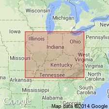
- Appalachian basin
Summary:
Pg. 296, 301. Magoffin beds. Proposed for the shales and limestones so extensively developed in southern Magoffin County, eastern Kentucky; not limited to that county, but probably have their most typical development there. In section at head of Sycamore Branch of Oakley Creek at home of Mrs. Sarah Salyers they consist of (descending): (1) shales, blue, black, clayey, and carbonaceous, 3.5 feet; (2) dove-colored limestone, 1 foot; (3) shales, upper part calcareous and very fossiliferous, 1.5 feet; (4) impure sandy limestone, fossiliferous, 0.4 feet; (5) shales, soft, blue, clayey, filled with plant fossils, 3 feet. This is perhaps an average section. Overlie Middle, "Taylor," or Copland coal; lie 35 feet below Saltlick beds and 220 or 230 feet above Kendrick shales. Can be traced from type locality through Knott and Breathitt Counties to North Fork of Kentucky River at Copland, where they form roof of coal mined there. Age is Pennsylvanian.
Source: US geologic names lexicon (USGS Bull. 896, p. 1267).
- Usage in publication:
-
- Magoffin limestone
- Modifications:
-
- Revised
- AAPG geologic province:
-
- Appalachian basin
Summary:
Pg. 94; R.C. Moore and others, 1944, GSA Bull., v. 55, no. 6, chart 6 (columns 21, 22, 23). Magoffin limestone. Marine shale with large concretions of limestone in Breathitt formation.
Source: US geologic names lexicon (USGS Bull. 1200, p. 2325).
- Usage in publication:
-
- Magoffin Member*
- Modifications:
-
- Revised
- AAPG geologic province:
-
- Appalachian basin
Summary:
Magoffin beds of Morse (1931) designated the Magoffin Member and assigned to the Breathitt Formation. Generally composed of an upward-coarsening sequence of shale, siltstone, and sandstone that contains marine fossils, mostly brachiopods, pelecypods, and gastropods. Lenses of fossil fragmental limestone are found near the base; lenses of micritic concretionary limestone occur higher in the shale. Basal contact is sharp; upper contact is a disconformity. Magoffin Member is above the Copland (Taylor) coal bed and below the Hazard (Winifrede) coal zone. Magoffin ranges from 0 to 200 ft in thickness. Age is latest Morrowan to earliest Atokan.
Source: GNU records (USGS DDS-6; Reston GNULEX).
- Usage in publication:
-
- Magoffin Member*
- Modifications:
-
- Revised
- AAPG geologic province:
-
- Appalachian basin
Summary:
Magoffin Member assigned to middle part of the Hignite Formation for use south of Pine Mountain in KY. In area north of Pine Mountain in KY, Magoffin remains member of Breathitt Formation.
Source: GNU records (USGS DDS-6; Reston GNULEX).
- Usage in publication:
-
- Magoffin Member
- Modifications:
-
- Revised
- AAPG geologic province:
-
- Appalachian basin
Summary:
Wise Formation in Lee Co., VA, includes (ascending) Cannelton Shale Member (White, 1885), Clover Fork Sandstone Member (Miller, 1969), Marcum Hollow Sandstone Member (Miller, 1969), Kendrick Shale Member (Jillson, 1919), and Magoffin Member (Morse, 1931). Also includes many named coal beds. Wise overlies Gladeville Sandstone.
Source: GNU records (USGS DDS-6; Reston GNULEX).

- Usage in publication:
-
- Magoffin Member
- Modifications:
-
- Revised
- AAPG geologic province:
-
- Appalachian basin
Summary:
Breathitt Formation is informally elevated to group rank and subdivided into the following eight informal formations: Pocahontas, Bottom Creek, Alvy Creek, Grundy, Pikeville, Hyden, Four Corners, and Princess formations. Magoffin Member is assigned to the base of the Four Corners formation. Overlies Taylor coal of the Hyden formation and underlies Haddix coal. [Revisions made in this paper are strongly contested by C. Rice and other USGS scientists who work in this area (oral commun., 9/3/93).]
Source: GNU records (USGS DDS-6; Reston GNULEX).

- Usage in publication:
-
- Magoffin Member
- Modifications:
-
- Revised
- AAPG geologic province:
-
- Appalachian basin
Summary:
Magoffin Member assigned to base of formally named Four Corners Formation of Breathitt Group in this report. According to the correlation chart, unit occurs across TN, KY, and VA in the Cumberland overthrust sheet, but is replaced in the Cumberland plateau of WV and VA by the Winifrede. The Winifrede, however, is not mentioned in the text. The Magoffin Member overlies coal-bearing strata of the Hyden Formation (new) and underlies variously named coal beds of the Four Corners. A generalized Pennsylvanian age is given for all of the Breathitt. According to the author, formal nomenclature presented in this report for units occurring in KY has been accepted by the Kentucky Stratigraphic Nomenclature Committee. Units that occur largely outside KY are considered informal. Report includes correlation charts, cross sections, and measured sections.
Source: GNU records (USGS DDS-6; Reston GNULEX).

- Usage in publication:
-
- Magoffin Member*
- Modifications:
-
- Areal extent
- AAPG geologic province:
-
- Appalachian basin
Summary:
Magoffin Member of Breathitt Formation. Marine unit in middle part of Breathitt Formation below the Haddix, Trace Fork, Red Ash, or Low Splint coals; lies above the Taylor, Copland, Sharp, or Limestone coal beds. Locally in Upper Cumberland River district lies below Reynolds Sandstone Member and above Jesse Sandstone Member. Age is Middle Pennsylvanian.
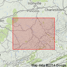
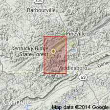
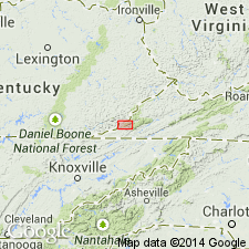
Recognized in Princess, Licking River, Hazard, Southwestern, and Big Sandy districts of eastern Kentucky, and Upper Cumberland River district, southeastern KY.
Source: Publication.

- Usage in publication:
-
- Magoffin Member
- Modifications:
-
- Areal extent
- AAPG geologic province:
-
- Appalachian basin
Summary:
Corr. chart. Magoffin Member of Four Corners Formation of Breathitt Group (KY); Magoffin Member of Redoak Mountain Formation (TN); Magoffin Member of Wise Formation (VA). Shale and/or mudstone. In Kentucky is basal member of Four Corners Formation. In eastern Kentucky lies below the Haddix coal zone; lies above the Copland (Taylor) coal bed of the Hyden Formation. In southeastern Kentucky [Upper Cumberland River district] lies below Reynolds Sandstone Member, which is capped by the Low Splint (Morris, No. 11) coal bed; lies above Jesse Sandstone Member of Hyden Formation, is separated from it by unnamed sandstone, siltstone, shale and/or mudstone, and the Sharp (Limestone) coal bed. In Tennessee is a member in upper part of Redoak Mountain Formation; lies below the Red Ash coal and above the Upper and Lower Sharp coals. In Virginia, is a member in upper part of Wise Formation; lies below Reynolds Sandstone Member, which is capped by the Morris (No. 11) coal zone, and lies below the Limestone coal bed. Correlates with Winifrede Shale Member of Kanawha Formation of West Virginia. [The Winifrede Shale Member lies below the Winifrede coal zone, which Eble and others (2009, Kentucky Geol. Survey, ser. XII, Spec. Pub. 10, fig. 5.2) placed at the Duckmantian/Bolsovian (Westphalian B/C) boundary on basis of miospores.] Carries marine fossils. Age is Middle Pennsylvanian (Westphalian; Atokan).
[Peppers (1996, GSA Memoir 188, p. 9, pl.) placed the Redoak Mountain Formation in lower part of Westphalian C, TORISPORA SECURIS-T. LAEVIGATA (SL) miospore assemblage zone of western Europe. Unpublished collections from overlying Stoney Fork Member of Princess Formation in Kentucky, and its equivalents, informal Lake City member of Cross Mountain Formation in Tennessee and Blunt Run (Boggs) limestone of Pottsville Group in Ohio, yielded distinctive conodonts correlative with the marine Aegir bed (=base of Westphalian C) thus shifting the Four Corners, Vowell Mountain, lower part of Cross Mountain, and upper part of Pottsville, downward into Westphalian B (R.G. Stamm, USGS, pers. commun., Oct. 17, 2013).]
[See also Chesnut, 1997 (revised Oct. 12, 1999), Stratigraphy of the coal-bearing strata of the Eastern Kentucky coal field, available online through the Kentucky Geol. Survey (http://www.uky.edu/KGS/coal/coalcorrel.htm) and geologic descriptions of stratigraphic units in the Kentucky Geological Survey database (http://kgs.uky.edu/kgsmap/KGSLitho/lithoSearch.asp#).]
[Peppers (1996, GSA Memoir 188, p. 9, pl.) placed the Redoak Mountain Formation in lower part of TORISPORA SECURIS-T. LAEVIGATA (SL) miospore assemblage zone of western Europe, = medial T. SECURIS-VESTISPORA FENESTRATA (SF) miospore assemblage zone of the Illinois basin; = middle Atokan, upper Duckmantian, Westphalian B (see Greb and others, and Eble and others, Kentucky Geol. Survey Spec. Pub., no. 10, ser. XII, 2009).]
[See also Chesnut, 1997 (revised Oct. 12, 1999), Stratigraphy of the coal-bearing strata of the Eastern Kentucky coal field, available online through the Kentucky Geol. Survey (http://www.uky.edu/KGS/coal/coalcorrel.htm) and geologic descriptions of stratigraphic units in the Kentucky Geological Survey database (http://kgs.uky.edu/kgsmap/KGSLitho/lithoSearch.asp#).]
Source: Publication.
For more information, please contact Nancy Stamm, Geologic Names Committee Secretary.
Asterisk (*) indicates published by U.S. Geological Survey authors.
"No current usage" (†) implies that a name has been abandoned or has fallen into disuse. Former usage and, if known, replacement name given in parentheses ( ).
Slash (/) indicates name conflicts with nomenclatural guidelines (CSN, 1933; ACSN, 1961, 1970; NACSN, 1983, 2005, 2021). May be explained within brackets ([ ]).