The National Geologic Map Database is migrating to a new infrastructure. We apologize for any service disruptions during this process.
|
|---|


- Usage in publication:
-
- Lee conglomerate*
- Modifications:
-
- Original reference
- Dominant lithology:
-
- Conglomerate
- Sandstone
- Shale
- Coal
- AAPG geologic province:
-
- Appalachian basin
Summary:
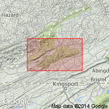
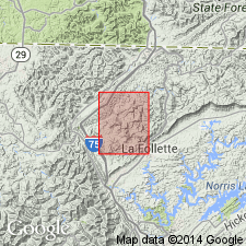
Pg. 28, 36. Lee conglomerate. Heavy sandstones, and conglomerate, shales, and coals, 1,200 to 1,600 feet thick. At Big Stone Gap [Wise County, southwestern Virginia) contains massive sandstone (Bee Rock), 95 feet thick, at top; heavy conglomerate, 250 feet thick, at base; and, in middle, 566 feet of sandstone with a few thin beds of shale. Overlies Pennington shale and underlies Norton formation. Is basal formation of Coal Measures in Bigstone Gap coal field of Virginia and Kentucky. [Age is Pennsylvanian.]
[Named from Lee Co., southwestern VA.]
Source: US geologic names lexicon (USGS Bull. 896, p. 1164-1165).
- Usage in publication:
-
- Lee group*
- Modifications:
-
- Revised
- AAPG geologic province:
-
- Appalachian basin
Summary:
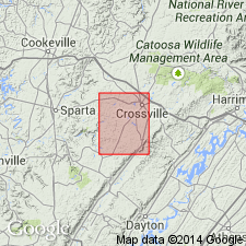
Pg. 5-17. Lee group. In Crossville quadrangle, [Tennessee], Lee group comprises (ascending) Gizzard formation, Sewanee conglomerate, Whitwell shale, Bonair [Bon Air] sandstone with Eastland shale lentil, Vandever shale, and Rockcastle sandstone. Underlies Briceville shale; overlies Pennington shale. [Age is Early Pennsylvanian.]
Source: US geologic names lexicon (USGS Bull. 1200, p. 2134-2135).
- Usage in publication:
-
- Lee formation
- Modifications:
-
- Revised
- AAPG geologic province:
-
- Appalachian basin
Summary:
Pg. 276. Lee formation. In Fentress County, [northern] Tennessee, comprises Rockcastle sandstone above and shale interval below, either simple or complex, for which name Fentress is suggested. [Age is Early Pennsylvanian.]
Source: US geologic names lexicon (USGS Bull. 1200, p. 2134-2135).
- Usage in publication:
-
- Lee group
- Modifications:
-
- Revised
- AAPG geologic province:
-
- Appalachian basin
Summary:
Pg. 38-53. Lee group. Rank raised to group and subdivided into (ascending) Gizzard formation (including Warren Point sandstone), Sewanee conglomerate, Whitwell shale, Herbert conglomerate, Eastland shale lentil, Newton sandstone, Vandever shale, Rockcastle conglomerate, and Duskin formation. Thickness 200 to 1,400 feet. Deposited on top of irregular eroded Pennington formation. Age is Early Pennsylvanian (early Pottsville).
Source: US geologic names lexicon (USGS Bull. 1200, p. 2134-2135).

- Usage in publication:
-
- Lee formation*
- Modifications:
-
- Overview
- AAPG geologic province:
-
- Appalachian basin
Summary:
Lee formation. Basal formation of Pottsville group. In east-central Tennessee the Lee itself becomes a group, composed of (descending) Rockcastle sandstone, Vandever shale, Bonair sandstone, Whitwell shale, Sewanee conglomerate, and Gizzard formation. In some early Kentucky reports the name Lee formation was applied to all beds up to top of Corbin conglomerate member, but later reports place top of Lee at top of Rockcastle conglomerate member. This is the USGS defnition. Age is Pennsylvanian.
Named from Lee Co., VA. [Also considered type locality (see US geologic names lexicon, USGS Bull. 1200, p. 2135).]
See also:
W.A. Nelson, 1925, Tennessee Div. Geol. Bull., no. 33-A, p. 38-53.
L.C. Glenn, 1925, Tennessee Div. Geol. Bull., no. 33-B, p. 276.
Charles Butts and W.A. Nelson, 1925, Tennessee Div. Geol. Bull., no. 33-D,
p. 5-17.
Source: US geologic names lexicons (USGS Bull. 896, p. 1164-1165; USGS Bull. 1200, p. 2134-2135).
- Usage in publication:
-
- Lee group
- Modifications:
-
- Revised
- AAPG geologic province:
-
- Appalachian basin
Summary:
Pg. 9-54. Discussion of strata of Lee age in Tennessee and lists following subdivisions (ascending): Gizzard formation, Sewanee conglomerate, Whitwell formation, Herbert sandstone, Eastland shale, Newton sandstone, Vandever shale, Rockcastle sandstone, Duskin Creek formation, Corbin conglomerate or sandstone, and Naese sandstone. [Age is Pennsylvanian.]
Source: US geologic names lexicon (USGS Bull. 1200, p. 2134-2135).
- Usage in publication:
-
- Lee formation*
- Modifications:
-
- Areal extent
- AAPG geologic province:
-
- Appalachian basin
Summary:
Pg. 9. Lee formation of Pottsville group. Described in coal field of southwest Virginia where outcrops are confined to northwest and southeast sides of field. Thickness about 900 feet in northwestern exposures ; 1,530 to 1,800 feet in southeastern area. Underlies Norton formation; overlies Bluestone formation. [Age is Early Pennsylvanian.]
Source: US geologic names lexicon (USGS Bull. 1200, p. 2134-2135).

- Usage in publication:
-
- Lee group[†]
- Modifications:
-
- [Abandoned]
- AAPG geologic province:
-
- Appalachian basin
Summary:
Lee group as used by Wanless (1946) discontinued, and units included in newly defined Gizzard, Crab Orchard Mountains, and Crooked Fork groups.
[Abandoned by the Tennessee Geol. Survey.]
Source: US geologic names lexicon (USGS Bull. 1200, p. 2134-2135).
- Usage in publication:
-
- Lee formation
- Modifications:
-
- Revised
- AAPG geologic province:
-
- Appalachian basin
Summary:
Eyl (1927, Structural geologic map of Lee County, Kentucky: Kentucky Geol. Survey, ser. 6) defined Lee formation as all of lower Pennsylvanian rocks from Mississippian-Pennsylvanian contact to top of Zachariah coal bed. In present report, top of Lee formation is lowered to base of Zachariah coal bed. Locally the Zachariah has a rider coal bed; hence, base of coal bed is more persistent horizon than top. Placing of top of formation at base of Zachariah coal follows Campbell (1898, USGS Geol. Atlas, Folio 47) who placed contact between Lee formation and Breathitt formation at base of Pittsburg (Kentucky) coal bed, which is probably equivalent of the Zachariah. Exposed thickness about 275 feet in Campton quadrangle, Kentucky. Underlies Breathitt formation. [Age is Early Pennsylvanian.]
Source: US geologic names lexicon (USGS Bull. 1200, p. 2134-2135).
- Usage in publication:
-
- Lee formation*
- Modifications:
-
- Areal extent
- AAPG geologic province:
-
- Appalachian basin
Summary:
Lee formation. In Scott and Campbell Counties, Tennessee, formation is about 850 feet thick and consists of massive beds of cross-bedded partly conglomeratic medium- to coarse-grained sandstone and thin beds of shale, siltstone, and coal. Overlies Pennington formation; underlies Briceville shale. [Age is Early Pennsylvanian.]
Source: US geologic names lexicon (USGS Bull. 1200, p. 2134-2135).
- Usage in publication:
-
- Lee formation*
- Modifications:
-
- Areal extent
- AAPG geologic province:
-
- Appalachian basin
Summary:
Term Lee formation extended into Tennessee by Keith (1896, USGS Geol. Atlas, Folio 25). In area of present report [Ivydell quadrangle, Tennessee], formation composed of massive conglomeratic sandstone, interbedded with siltstone, shale, and a few thin beds of coal and underclay. Various sandstone beds have been designated as top of Lee, but, because these beds are gradational and lenticular in this area, upper contact of Lee is drawn at base of persistent Red coal of Ashley and Glenn (1906, USGS Prof. Paper 49). Thickness 900 to 1,400 feet. Overlies Pennington formation; underlies Briceville shale. [Age is Early Pennsylvanian.]
Source: US geologic names lexicon (USGS Bull. 1200, p. 2134-2135).
- Usage in publication:
-
- Lee formation
- Modifications:
-
- Areal extent
- AAPG geologic province:
-
- Appalachian basin
Summary:
Upper part of Pennington formation and lower part of Lee formation intertongue in their type area of outcrop, Lee County, Virginia, and in adjacent parts of Kentucky and Tennessee. Contact between these formations, which has been interpreted as an unconformity between Mississippian and Pennsylvanian systems, is transitional as result of intertonguing and lateral gradation between marine and nonmarine facies. Lateral gradation is most evident in sandstone beds, which in Lee formation are characteristically thickly crossbedded fine- to coarse-grained quartzose, conglomeratic sandstones as much as 300 feet thick. These sandstone tongues of the Lee grade laterally to thin wavy-bedded, very fine- to fine-grained sandstones, 20 to 30 feet thick that are typical of, and are included in, the Pennington. Conversely, tongues of light~olive-gray slightly calcareous shale in upper part of Pennington wedgeout between sandstone tongues of Lee formation. Pennington-Lee contact rises stratigraphically northward in this intertonguing sequence. Marine invertebrate fossils indicate Late Mississippian age of Pennington. Plant fossils have been reported to show that Lee formation is of Early Pennsylvanian age. Intertonguing of Lee and Pennington suggests that they are partly contemporaneous.
Source: US geologic names lexicon (USGS Bull. 1200, p. 2134-2135).
- Usage in publication:
-
- Lee Formation*
- Modifications:
-
- Principal reference
- Revised
- Age modified
- AAPG geologic province:
-
- Appalachian basin
Summary:
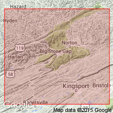
Lee Formation. Fine- to coarse-grained, subangular to subrounded, white to very light-gray, conglomeratic sandstone; commonly more than 90 percent quartz. Thickness averages 1,600 feet in Cumberland Mountain area, thins northwestward. Divided into (descending) Bee Rock Sandstone Member, Hensley Member (new), Middlesboro Member (new), Dark Ridge Member (new), White Rocks Sandstone Member, Chadwell Member (new), and Pinnacle Overlook Member (new). Includes Tunnel and Cumberland Gap coal beds. Underlies Hance Formation; overlies and intertongues with Pennington Formation. Age is Mississippian to Pennsylvanian.
Type section: "best exposed" section at Big Stone Gap, Wise Co., southwestern VA, described by Campbell (1893).
[Reference section (composite): new highway cuts in Cumberland Gap area, Bell Co., southeastern KY, and Lee Co., southwestern VA (see fig. 1).]
Source: Publication.
- Usage in publication:
-
- Lee Formation*
- Modifications:
-
- Age modified
- AAPG geologic province:
-
- Appalachian basin
Summary:
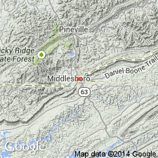
The Lee Formation is as much as 1500 ft thick in the type area in Cumberland Mountain where it has been divided into eight members. The Pinnacle Overlook, Chadwell, White Rocks Sandstone, Middlesboro, Bee Rock Sandstone, and Naese Sandstone Members are mostly quartzose sandstone and conglomerate. The Dark Ridge and Hensley Members are mostly shale, siltstone, thin-bedded silty sandstone, and coal. The lower three of these members, the Pinnacle Overlook, Chadwell, and White Rocks Sandstone are assigned to the Upper Mississippian Series. The overlying quartzose sandstone members of the Lee are Early to Middle Pennsylvanian in age. West of the Cumberland overthrust sheet, in the Pottsville escarpment area, the Lee Formation is limited to several quartzose sandstone units: the Livingston Conglomerate, the Rockcastle Conglomerate, and the Corbin Sandstone Members and the Grayson sandstone bed of Wittington and Ferm (1967). Strata that intervene between these units are assigned to the Breathitt Formation.
Source: GNU records (USGS DDS-6; Reston GNULEX).
- Usage in publication:
-
- Lee Formation
- Modifications:
-
- Revised
- AAPG geologic province:
-
- Appalachian basin
Summary:
Pinnacle Overlook Member, a 230-ft resistant sandstone, "properly belongs in the Mississippian Pennington Formation." Usage here agrees with that of Vanover (1989: Eastern KY Univ. M.S. thesis). According to authors, Englund's (1964) interpretation of a Pinnacle Overlook Member of the Lee Formation that intertongues with the upper member of the Pennington was based on a misidentification of the Chadwell Member of the Lee along the ridge at TriState-Peak. In this report Pennington Formation unconformably underlies the Chadwell Member of the Lee Formation and the Lee is entirely Pennsylvanian.
Source: GNU records (USGS DDS-6; Reston GNULEX).

- Usage in publication:
-
- Lee Formation
- Modifications:
-
- Revised
- AAPG geologic province:
-
- Appalachian basin
Summary:
Sequence of unique rocks exposed along Hwy 80 in the Billows quad., Laurel Co., KY, here informally named the Poison Honey beds of the Lee Formation. Described as matrix-supported conglomerate and sandstone lenses deposited by complex mass flows. Approximately 10 m thick. Limited in extent; they do not continue beyond the limits of the hillside bounding the Rockcastle River and Pine Creek. Stratigraphically overlie the informal Pine Creek sandstone of the Lee and are truncated by unnamed channel-fill deposits of the Lee.
Source: GNU records (USGS DDS-6; Reston GNULEX).
- Usage in publication:
-
- Lee Formation*
- Modifications:
-
- Revised
- AAPG geologic province:
-
- Appalachian basin
Summary:
Coal-bearing strata of this area previously mapped as Lee Formation are reassigned to the Pocahontas and New River Formations. Lee Formation conglomeratic sandstone wedges out and Pocahontas has been recognized in the map area. These strata include subgraywacke sandstones in the Pocahontas and New River Formations.
Source: GNU records (USGS DDS-6; Reston GNULEX).

- Usage in publication:
-
- Lee Formation
- Modifications:
-
- Not used
- AAPG geologic province:
-
- Appalachian basin
Summary:
Name Lee Formation "formally dropped" as a formation in KY. Units previously recognized as sandstone members of the Lee are here raised to formation rank and assigned to the Breathitt Group. According to the author, formal nomenclature presented in this report for units occurring in KY has been accepted by the Kentucky Stratigraphic Nomenclature Committee. Units that occur largely outside KY are considered informal.
Source: GNU records (USGS DDS-6; Reston GNULEX).
- Usage in publication:
-
- Lee Formation*
- Modifications:
-
- Revised
- AAPG geologic province:
-
- Appalachian basin
Summary:
Report corrects identification of units in pilot bore section by Vanover and others (1989, Itinerary, Day 2-Pilot bore traverse, IN Dean, C.S., and Moshier, S.O., eds., Cumberland Mountain: the inside story: Geological Survey of Kentucky Field Trip Guidebook, p. 24-30) and by Vanover (1989, Pilot tunnel stratigraphy, IN Dean, C.S., and Moshier, S.O., eds., Cumberland Mountain: the inside story: Geological Survey of Kentucky Field Trip Guidebook, p. 39-43). Rocks identified as Pinnacle Overlook Member of the Lee are now identified as lower unnamed member of Pennington Formation. Rocks identified as Chadwell Member of Lee are now identified as Pinnacle Overlook Member and part of upper part of unnamed member of Pennington. Rocks identified as Dark Ridge Member of Lee are now identified as the rest of upper part of upper member of Pennington. Rocks identified as Middlesboro Member of Lee are now identified as a sequence including Chadwell, Dark Ridge, and Middlesboro Members. Pinnacle Overlook Member and lower part of Chadwell Member of Lee Formation intertongue with Pennington Formation.
Source: GNU records (USGS DDS-6; Reston GNULEX).
For more information, please contact Nancy Stamm, Geologic Names Committee Secretary.
Asterisk (*) indicates published by U.S. Geological Survey authors.
"No current usage" (†) implies that a name has been abandoned or has fallen into disuse. Former usage and, if known, replacement name given in parentheses ( ).
Slash (/) indicates name conflicts with nomenclatural guidelines (CSN, 1933; ACSN, 1961, 1970; NACSN, 1983, 2005, 2021). May be explained within brackets ([ ]).