

- Usage in publication:
-
- Rhinestreet shale
- Modifications:
-
- Named
- Dominant lithology:
-
- Shale
- AAPG geologic province:
-
- Appalachian basin
Summary:
Named Rhinestreet shale for black shale that underlies the Angola shale and overlies the Cashaqua shale. Unit is included in the Naples beds of western NY.
Source: GNU records (USGS DDS-6; Reston GNULEX).
- Usage in publication:
-
- Rhinestreet Shale Member*
- Modifications:
-
- Areal extent
- AAPG geologic province:
-
- Appalachian basin
Summary:
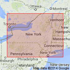
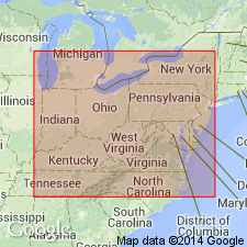
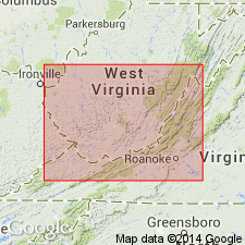
Rhinestreet Shale Member of West Falls Formation extended from southwestern NY into western PA, eastern OH, western WV, eastern KY, western VA, and eastern TN.
Source: GNU records (USGS DDS-6; Reston GNULEX).

- Usage in publication:
-
- Rhinestreet Shale Member
- Modifications:
-
- Revised
- AAPG geologic province:
-
- Appalachian basin
Summary:
In this study, the Chattanooga Shale is divided into (ascending) Rhinestreet Shale, Upper Olentangy Shale, Ohio Shale, Bedford Shale, Berea Sandstone, and Sunbury Shale Members. Throughout most of the region, the dominant lithology is black, organic-rich shale (Rhinestreet, Ohio, and Sunbury). The Chattanooga thins westward. Geophysical logs indicate that in the western region, unit consists of only the Sunbury, Berea-Bedford, and Ohio Members, the Rhinestreet and Olentangy having pinched out. The Upper Devonian Rhinestreet is observed only in the eastern half of the Hazard strike section. According to the author, formal nomenclature presented in this report has been accepted by the Kentucky Stratigraphic Nomenclature Committee. Report includes correlation charts, cross-sections, and measured sections.
Source: GNU records (USGS DDS-6; Reston GNULEX).

- Usage in publication:
-
- Rhinestreet Shale Member*
- Modifications:
-
- Overview
- AAPG geologic province:
-
- Appalachian basin
Summary:
In outcrop in western NY, the West Falls consists of a lower black shale, the Rhinestreet Shale Member and an upper gray shale and mudrock with abundant limestone nodules, the Angola Shale Member. Both members interfinger to the east into an eastward-thickening sequence of siltier and sandier rocks. The Angola is not recognized east of the Genesee River, although the Rhinestreet is present near Elmira in central Chemung Co., NY. The Rhinestreet is also identified in the subsurface from western NY to eastern TN. In outcrop in TN, the Rhinestreet is a 6-ft bed in the lower part of the Dowelltown Member of the Chattanooga Shale. The Belpre Ash Bed is present in the lower part of the Rhinestreet in the western part of the Appalachian basin. In the subsurface, the Angola is recognized from western NY to eastern TN and westward into OH and eastern KY. Extends further west than the Rhinestreet, underlying the Pipe Creek Shale Member of the Java Formation.
Source: GNU records (USGS DDS-6; Reston GNULEX).
- Usage in publication:
-
- Rhinestreet Shale Member
- Modifications:
-
- Revised
- AAPG geologic province:
-
- Appalachian basin
Summary:
Cross section between Norton and Asberrys, VA, in the Clinch Mountain outcrop belt shows more detailed divisions of Chattanooga Shale than previously indicated. Base of Chattanooga is marked by Belpre Ash. Ascending, members are Rhinestreet Shale, Angola Shale, Java Shale (including the Center Hill Ash), Dunkirk Shale Tongue of Huron Shale Member and remaining upper part of Huron, Three Lick Bed, Cleveland Shale Member, and Sunbury Shale Member. According to authors, divisions are based on careful outcrop description and outcrop gamma-ray log. Divisions can be traced by borehole gamma-ray logs to their type areas in OH and NY.
Source: GNU records (USGS DDS-6; Reston GNULEX).
For more information, please contact Nancy Stamm, Geologic Names Committee Secretary.
Asterisk (*) indicates published by U.S. Geological Survey authors.
"No current usage" (†) implies that a name has been abandoned or has fallen into disuse. Former usage and, if known, replacement name given in parentheses ( ).
Slash (/) indicates name conflicts with nomenclatural guidelines (CSN, 1933; ACSN, 1961, 1970; NACSN, 1983, 2005, 2021). May be explained within brackets ([ ]).