

- Usage in publication:
-
- Needle Siltstone Member
- Modifications:
-
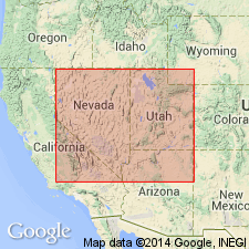
- Named
- Dominant lithology:
-
- Siltstone
- AAPG geologic province:
-
- Great Basin province
Summary:
Named as lowermost of six lithostratigraphic members of Chainman Formation, members of which intertongue with each other. Needle Siltstone Member is about 500 ft thick. Underlies Skunk Spring Limestone Member (new) (Chainman Formation). Age of Chainman Formation based on ammonite [goniatite] zone analysis is Late Mississippian.
Source: GNU records (USGS DDS-6; Menlo GNULEX).
- Usage in publication:
-
- Needle Siltstone Member*
- Modifications:
-
- Overview
- AAPG geologic province:
-
- Great Basin province
Summary:
Is one of six members assigned to Chainman Shale in report area, western UT, Great Basin province. Consists of distal-flysch siltstone containing abundant grazing traces (COSMORHAPE) and near the base, phosphatic brachiopods, ORBICULOIDEA and LINGULA. Marks the last vestige of starved-basin deposition. The last vestige of deep-water starved-basin deposition noted from the scattering of phosphate nodules throughout the lower part of the member. Age is interpreted to be entirely Meramecian because it overlies phosphatic member (later part of early Meramecian age) and underlies concretionary shale member (earlier part of late Meramecian age). All are members of Chainman Shale. Columnar sections.
Source: GNU records (USGS DDS-6; Denver GNULEX).
- Usage in publication:
-
- Needle Siltstone Member*
- Modifications:
-
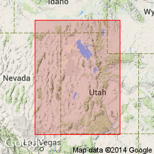
- Principal reference
- Revised
- Adopted
- Dominant lithology:
-
- Siltstone
- AAPG geologic province:
-
- Great Basin province
Summary:
Adopted as a member--one of two described--of Chainman Shale. Named in a thesis for exposures in the Needle Range of southwest UT in the Great Basin province; these exposures considered to be the type locality. Principal reference section designated in Ledger Canyon in the Confusion Range, Milllard Co, UT, also in the Great Basin province. Overlies the informal phosphatic member, basal member of the Chainman. Overlain by Skunk Spring Limestone Bed (new) of Chainman. Shown at type on cross section as consisting of basal sandstone overlain by siltstone that are 175+ ft thick.
Needle is a member of Woodman Formation. Assigned to Woodman Formation at Buckhorn Canyon in Dugway Range, at Pool Canyon and Guilmette Gulch in Tooele Co. Considered to be a bioturbated, distal-flysch facies. Mississippian age.Needle Siltstone Member of Chainman Shale (Sadlick, 1965) is adopted. Measured type section designated in Needle Range, center SE/4 sec. 26, T25S R19W, Mountain Home Pass 7.5' quad, Millard Co, UT. Principal reference section is designated at Ledger Canyon, Confusion Range, UT. Overlies phosphatic member (Chainman Shale or Woodman Formation). Underlies Skunk Spring Limestone Bed (of concretionary shale member of Chainman Shale of Sandberg and others, 1980). Needle Siltstone Member is also member within Woodman Formation at Buckhorn Canyon, Pool Canyon, and Guilmette Gulch. Represents bioturbated, distal-flysch facies. [Menlo GNU]
Source: GNU records (USGS DDS-6; Denver GNULEX).
- Usage in publication:
-
- Needle Siltstone Member*
- Modifications:
-
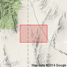
- Mapped 1:24k
- Dominant lithology:
-
- Siltstone
- Sandstone
- AAPG geologic province:
-
- Great Basin province
Summary:
Is mapped as a member (Meramecian) of Chainman Formation (Mississippian) in Mountain Home Range in western Millard Co, southwest UT (Great Basin province). Subdivisions of the Chainman mostly follow Sadlick (1965) with addition of two members below his Needle Member. Sandberg and others (1980) have listed conodont zones using Sadlick's subdivisions. Overlies Delle Phosphatic Member (Meramecian and Osagean) of the Chainman. Overlain by Skunk Spring Limestone Bed (Meramecian) of the Chainman. Map unit described as siltstone, gray, weathers light brownish gray, calcareous, mostly thin bedded; includes 10% fine-grained sandstone and minor shale; occasional trace fossils; thickness 180 m.
Source: GNU records (USGS DDS-6; Denver GNULEX).
- Usage in publication:
-
- Needle Siltstone Member*
- Modifications:
-
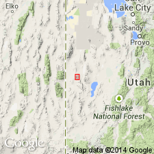
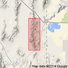
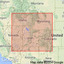
- Areal extent
- AAPG geologic province:
-
- Great Basin province
Summary:
Exposed mainly in Whitehorse Pass area of Bluebell and Goshute Peak Wilderness Study areas, Elko Co., NV. Consists of siltstone containing abundant trace fossils. Has thin phosphorite bed at base. Age given as Mississippian.
Source: GNU records (USGS DDS-6; Menlo GNULEX).

- Usage in publication:
-
- Needle Siltstone Member*
- Modifications:
-
- Mapped 1:24k
- Dominant lithology:
-
- Siltstone
- Sandstone
- AAPG geologic province:
-
- Great Basin province
Summary:
Is mapped as a member (Meramecian) of Chainman Formation (Mississippian) in southern part of Mountain Home Range in western Millard and Beaver Cos, southwest UT (Great Basin province). Subdivisions of the Chainman mostly follow Sadlick (1965, 1966) with addition of Delle Phosphatic Member (Sandberg and Gutschick, 1984) at base of formation. Sandberg and others (1980) have listed Chainman conodont zones using Sadlick's subdivisions. Overlies Delle Phosphatic Member (Meramecian and Osagean) of the Chainman. Overlain by Skunk Spring Limestone Member (Meramecian) of the Chainman. Map unit described as siltstone, gray, weathers light brownish gray, calcareous, mostly thin-bedded; includes 10% fine-grained sandstone and minor shale; minor trace-fossils; thickness 180 m.
Source: GNU records (USGS DDS-6; Denver GNULEX).
- Usage in publication:
-
- Needle Siltstone Member*
- Modifications:
-
- Age modified
- Areal extent
- AAPG geologic province:
-
- Great Basin province
Summary:
Overall unit age revised from Late Mississippian to: Early and Late Mississippian based on fossils [conodonts]. Geographically extended into the southern Ruby Mountains, NV (Early and Late Mississippian) and the Indian Creek and Cherry Creek Mountains, NV (Early and Late Mississippian) as a member of the Chainman Shale. Geographically extended as member of the Woodman Formation into the South Lakeside Mountains, UT (Late Mississippian), and the Silver Island Mountains, UT (Early and Late Mississippian). Age revised in the Confusion Range from Late Mississippian to: Early(?) and Late Mississippian; in the northern Deep Creek Mountains, UT, from Late Mississippian to: Early and Late Mississippian; in the Dugway Range, UT, from Late Mississippian to: Early and Late Mississippian.
Source: GNU records (USGS DDS-6; Menlo GNULEX).
For more information, please contact Nancy Stamm, Geologic Names Committee Secretary.
Asterisk (*) indicates published by U.S. Geological Survey authors.
"No current usage" (†) implies that a name has been abandoned or has fallen into disuse. Former usage and, if known, replacement name given in parentheses ( ).
Slash (/) indicates name conflicts with nomenclatural guidelines (CSN, 1933; ACSN, 1961, 1970; NACSN, 1983, 2005, 2021). May be explained within brackets ([ ]).