

- Usage in publication:
-
- Molas formation*
- Modifications:
-
- Original reference
- Dominant lithology:
-
- Sandstone
- Shale
- AAPG geologic province:
-
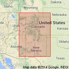
- San Juan Mountains province
Summary:
and GSA Bull. v. 16, p. 470-496. Molas formation. Red calcareous shales and sandstones with chert, limestone, and quartzite pebbles and thin fossiliferous limestone lenses. The limestone lenses contain Pennsylvanian fossils. The chert and limestone pebbles often contain fossils from Mississippian part of underlying Ouray limestone, with which it is unconformable. Thickness 75 feet. Is conformably overlain by Hermosa formation. The Molas is absent in area where Hermosa formation was first defined, and therefore was not included in original Hermosa. [Age is Pennsylvanian.]
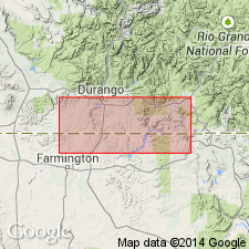
[Named from Molas Lake, in San Juan Mountains on Durango-Silverton Highway, Needle Mountains quadrangle, San Juan Co., southwestern CO.]
[GNC remark (ca. 1936, US geologic names lexicon, USGS Bull. 896, p. 1397): The Mississippian part of Ouray limestone as first defined is now called Leadville limestone, and Ouray limestone is restricted to the Upper Devonian part. (See Ouray entry under Kirk, 1931).]
Source: US geologic names lexicons (USGS Bull. 896, p. 1397; supplemental information from USGS Bull. 1200, p. 2549-2550).
- Usage in publication:
-
- Molas formation
- Modifications:
-
- Areal extent
- AAPG geologic province:
-
- San Juan basin
- Paradox basin
Summary:
Pg. 2166-2168. Molas formation. Described in Paradox Salt basin. Divisible into three members. Lowest, varicolored claystone, predominantly red, containing solution-rounded limestone fragments of Mississippian age which appear to be limestone-chert regolith cemented by calcareous silty claystone; regolith fills depressions on karst surface developed in upper 10 to 100 feet of Leadville limestone. Middle, variable siltstone and shale with some intraformational conglomerate. Upper, not everywhere present, is marine red and green shale-sandstone sequence containing fossils of Des Moines age. Thickness. wedge-edge to 200 feet. Underlies Pinkerton Trail formation (new). Formation contains series horizons between Morrow and Atoka, and Atoka and Des Moines. This is section well exposed at type locality. Inasmuch as Molas shale was almost completely covered in areas where Hermosa formation was first studied, it was not described or included in original Hermosa section. It is now recognized that Molas is found only where Mississippian limestone is or was present beneath Pennsylvanian strata.
Source: US geologic names lexicon (USGS Bull. 1200, p. 2549-2550).
- Usage in publication:
-
- Molas formation*
- Modifications:
-
- Areal extent
- AAPG geologic province:
-
- Piceance basin
Summary:
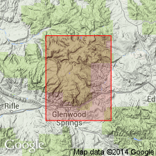
Sequence of intermixed red residuum and conglomerate recognized as the Molas formation at Molas Lake, in the Animas valley, extends south into the subsurface of northwest NM, San Juan basin and is also developed at north edge of Glenwood Springs, Garfield Co, CO, Piceance basin. Lies above the cavernous Leadville limestone at these localities. Underlies Hermosa formation in southwest CO and Belden shale in central CO. Forams of early Middle Pennsylvanian age found in the Hermosa. Forams of Morrow? age found in the Belden. All that is known of the age of the Molas is that it accumulated between the Early Mississippian and the early Middle Pennsylvanian. The red detritus and residuum are widely distributed in the Rocky Mountain region from northern NM to MT. The detritus is usually nonfossiliferous; it is overlain by clastics and carbonates of Late Mississippian or very early Pennsylvanian to Middle Pennsylvanian. Assigned to the Pennsylvanian.
Source: GNU records (USGS DDS-6; Denver GNULEX).
- Usage in publication:
-
- Molas formation*
- Modifications:
-
- Revised
- AAPG geologic province:
-
- San Juan Mountains province
Summary:
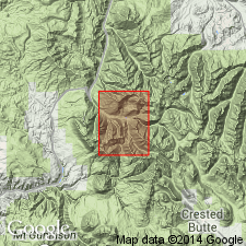
Pg. 2107-2131. Molas formation. Includes three members, descending: (1) upper member, sandstone, shale, siltstone, mudstone, breccia, and limestone, up to 25 feet thick, fossils indicate Pennsylvanian age, probably early and/or medial Pennsylvanian; (2) middle member, interbedded siltstone, shale, conglomerate, and sandstone, average thickness 40 feet; (3) lower member, Coalbank Hill member (new), up to 56 feet thick. Total thickness as much as 140 feet. Overlies Leadville or Ouray limestone. Underlies Pinkerton Trail formation. Mississippian-Pennsylvanian boundary probably within Coalbank Hill member or overlying middle member.
Source: Publication; US geologic names lexicon (USGS Bull. 1200, p. 2549-2550).
- Usage in publication:
-
- Molas Formation*
- Modifications:
-
- Areal extent
- AAPG geologic province:
-
- Eagle basin
Summary:
Overlies karstic surface at top of Leadville Limestone. Underlies Belden Formation. Identified in a measured section in secs 24 and 25, T4S, R87W, Eagle Co, CO in the Eagle basin where it is a 9 ft thick purple-maroon (yellow to orange weathered) clay. Has spherical to elliptical concretions or boulders of dark-brown quartzite that are as much as 10 inches in diameter. Geologic map; mapped with overlying Belden Formation. The only fossils found are in chert in concretions derived from Leadville Limestone. Age of Molas could be Late Mississippian to Early Pennsylvanian. If it is of two ages, the Mississippian part cannot be separated from the Pennsylvanian part. Assigned a Pennsylvanian age on geologic map.
Source: GNU records (USGS DDS-6; Denver GNULEX).
- Usage in publication:
-
- Molas Formation*
- Modifications:
-
- Areal extent
- AAPG geologic province:
-
- Eagle basin
- Piceance basin
Summary:
Mapped in the south-central and southeast, and northeast parts of the quad (Ts10 and 11S, R88W) in Gunnison Co (Piceance basin) and Pitkin Co (Eagle basin), CO. Unconformably overlies Leadville Limestone. Underlies Belden Formation. Ranges from 0-50 ft thick. Consists of gray to black argillite that grades up into gray fine-grained argillite and siltstone. Lower part contains reworked varicolored nodules, pebbles, and fragments of chert and quartzite on the karst surface at the top of the Leadville. Metamorphosed to hornfels and quartzite. Pennsylvanian age.
Source: GNU records (USGS DDS-6; Denver GNULEX).
- Usage in publication:
-
- Molas Formation*
- Modifications:
-
- Areal extent
- AAPG geologic province:
-
- Plateau sedimentary province
Summary:
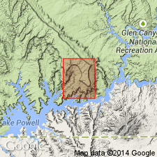
The name Molas Formation of Early Pennsylvanian age geographically extended westward from Paradox basin into the subsurface of Kane Co, UT in Plateau sedimentary province, where it unconformably overlies the Upper Mississippian Horseshoe Mesa Member of Redwall Limestone and it underlies the Hermosa Formation. Molas is 154 ft thick. It consists of maroon shale and, in the middle part, a light-brown limestone that has algal structures and chert. Columnar section. A marine and nonmarine deposit.
Source: GNU records (USGS DDS-6; Denver GNULEX).
- Usage in publication:
-
- Molas Shale*
- Modifications:
-
- Areal extent
- AAPG geologic province:
-
- Piceance basin
Summary:
Identified in subsurface of Moffat Co, CO, Piceance basin, as a thin shale remnant. Overlies Madison Limestone. Underlies Belden Shale. [Nearby on outcrop the pre-Weber Sandstone Pennsylvanian sequence is assigned to Round Valley Limestone (base) and Morgan Formation.]
Source: GNU records (USGS DDS-6; Denver GNULEX).
- Usage in publication:
-
- Molas Formation*
- Modifications:
-
- Age modified
- AAPG geologic province:
-
- San Juan basin
- San Juan Mountains province
- Piceance basin
- Eagle basin
Summary:
Is typically a clastic redbed sequence of silty, variegated shale with chert or limestone nodules, red to brown siltstone, and limestone. Lower part considered to a residual soil that covered a karst surface on the Leadville Limestone. May be as much as 70 ft thick. Locally a few inches to a few feet of Molas lie between Leadville and the overlying Belden Formation. Has been assigned a Pennsylvanian age but could be an old regolith formed in late Visean and Namurian time that was reworked by Early Pennsylvanian or younger transgression. Recognized in the subsurface of the San Juan basin, and on outcrop in the San Juan Mountains (San Juan Mountain province), Sangre de Cristo Mountains, Mosquito and Sawatch Ranges, and Glenwood Springs, CO (Eagle basin, Piceance basin).
Source: GNU records (USGS DDS-6; Denver GNULEX).
- Usage in publication:
-
- Molas Formation*
- Modifications:
-
- Areal extent
- AAPG geologic province:
-
- Black Mesa basin
- Paradox basin
- San Juan basin
Summary:
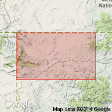
Pg. A5 (fig. 3), A18, A21 (fig. 10, isopach map), A22-A23, pl. 1 (geol. map). Molas Formation. Consists of (ascending): (1) Coalbank Hill Member, red, purplish-red, and reddish-brown siltstone, and chert- and limestone-pebble conglomerate, thickness up to 56 feet; (2) unnamed middle member, interbedded reddish-brown shale, siltstone, mudstone, sandstone, and conglomerate, thickness averages 40 feet; and (3) unnamed upper member, similar to lower members, also includes maroon, pink, and light-gray sandstone, thickness averages 25 feet. Total thickness up to 25 feet (geol. map) [not separately mapped]; up to 120 feet southwest of Reservation (fig. 10, isopach map). Conformably underlies Middle to Upper(?) Pennsylvanian (Atokan to Virgilian?) Hermosa Group (or Hermosa Formation). Unconformably overlies Lower Mississippian Leadville Limestone; top of Leadville deeply eroded karst topography. Fossils. Age is Late Mississippian(?) to Middle Pennsylvanian (Chesterian? to Atokan) [on geol. map stratigraphic range of Molas stated as Pennsylvanian].
Recognized in the Four Corners region of southwestern Colorado, northwestern New Mexico, northeastern Arizona, and southeastern Utah.
Source: Publication.
- Usage in publication:
-
- Molas Formation*
- Modifications:
-
- Areal extent
- AAPG geologic province:
-
- San Juan basin
- Black Mesa basin
- Paradox basin
Summary:
Log Springs Formation in the Nacimiento Mountains of NM, San Juan basin is lithologically similar to the Coalbank Hill Member and middle member of the Molas Formation of the northern part of the San Juan basin. The lower strata of the Log Springs are a regolith on carbonate rocks of the Arroyo Penasco Group. Basal Molas to the north is a regolith on Leadville Limestone. Log Springs is inferred to be Late Mississippian on basis of position between dated units. The Molas and Log Springs are shown together on an isopach map; a line of demarcation between the two units is drawn in northwest Sandoval Co., NM. Southeast of this line, the Log Springs shown as thickening to 100+ ft. Molas extends northward into Black Mesa and Paradox basins. Correlation chart. Cross sections. Map unit --Log Springs and Molas considered Mississippian and Pennsylvanian age.
Source: GNU records (USGS DDS-6; Denver GNULEX).
For more information, please contact Nancy Stamm, Geologic Names Committee Secretary.
Asterisk (*) indicates published by U.S. Geological Survey authors.
"No current usage" (†) implies that a name has been abandoned or has fallen into disuse. Former usage and, if known, replacement name given in parentheses ( ).
Slash (/) indicates name conflicts with nomenclatural guidelines (CSN, 1933; ACSN, 1961, 1970; NACSN, 1983, 2005, 2021). May be explained within brackets ([ ]).