The National Geologic Map Database is migrating to a new infrastructure. We apologize for any service disruptions during this process.
|
|---|


- Usage in publication:
-
- Arikaree formation*
- Modifications:
-
- Original reference
- Dominant lithology:
-
- Sand
- Ash
- Conglomerate
- AAPG geologic province:
-
- Denver basin
- Chadron arch
Summary:
Pg. 732, 735, 742, 743-748, pls. 82, 83, 84, 85, 88. Arikaree formation. Series of gray sands, everywhere characterized by layers of dark-gray concretions which often have a tubular form, underlying Ogallala formation in western Nebraska with distinct erosional unconformity and overlap. Rests (usually conformably) on Gering formation, where that formation is present; where Gering is absent, on Brule clay. There is possibility upper member of Gering formation may be basal part of Arikaree formation. The Arikaree enters Nebraska from Wyoming, and thins out beneath Ogallala formation in eastern part of Banner County. Thickness 400 feet in Scotts Bluff County and 500 feet in Sioux and Dawes Counties, the thickness increasing as the Arikaree displaces the Ogallala formation northward. Extensively exposed along Niobrara River, apparently to east of Valentine, and occasionally seen along western edge of sand-hill district, but not yet distinctly recognized in region drained by Loup Forks or along Platte River east of Cheyenne County. In upper parts are beds containing the large DAEMONELIX of Barbour. The formation includes large amount of volcanic ash as a general admixture in its sediments as well as in beds of considerable extent and thickness. Also contains a number of channels filled out with conglomerate. The name Arikaree is applied to the formation because Arikaree Indians were at one time identified with area in which it is most largely developed. [Recognized in western Nebraska, southeastern Wyoming, southern South Dakota, and northeastern Colorado. Age is early Tertiary (Miocene).]
Source: US geologic names lexicon (USGS Bull. 896, p. 70-71).
- Usage in publication:
-
- Arikaree formation*
- Modifications:
-
- Mapped
Summary:
Darton mapped Arikaree formation across western northern Nebraska up to South Dakota line, but did not show any Ogallala above it in that area. In 1909 (USGS Water Supply Paper 227) Darton mapped Arikaree formation across southern South Dakota from near Fall River County on west to beyond Missouri River on east, did not show any younger formation, and did not mention presence of Ogallala formation in South Dakota.
Source: US geologic names lexicon (USGS Bull. 896, p. 70-71).
- Usage in publication:
-
- Arikaree formation*
- Usage in publication:
-
- Arikaree formation*
- Modifications:
-
- Areal extent
- AAPG geologic province:
-
- Denver basin
- Powder River basin
Summary:
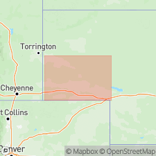
Miocene Arikaree formation mapped with Ogalalla [sic] formation from south boundary of State east of Rocky Mountains (Laramie Mountains), and north to Lusk in Laramie, Goshen, Platte, southeast Converse, and southern Niobrara Cos in the Powder River basin, southeastern WY. West of Laramie Mountains Miocene and Pliocene rocks mapped as one unnamed unit.
Source: GNU records (USGS DDS-6; Denver GNULEX).
- Usage in publication:
-
- Arikaree Group
- Modifications:
-
- Revised
- AAPG geologic province:
-
- Chadron arch
Summary:
New stratigraphic unit recognized at base of Arikaree Group above Brule formation of White River Group and below Monroe Creek Formation of Arikaree. New formation is named Sharps Formation for Sharps Corner in Shannon Co, SD on the Chadron arch. A volcanic ash bed in the Sharps named Rockyford ash [an unranked designation]. Arikaree Group is Miocene age.
Source: GNU records (USGS DDS-6; Denver GNULEX).
- Usage in publication:
-
- Arikaree Formation*
- Modifications:
-
- Areal extent
- AAPG geologic province:
-
- Wind River basin
Summary:
Lower and middle Miocene rocks of the Granite Mountains area, Natrona and Fremont Cos, WY in the Wind River basin are mostly wind-blown, fine- to medium-grained, tuffaceous sandstone and very minor limestone, tuff, and conglomerate beds about 1,000 ft thick. These rocks have been mapped from Oregon Buttes, WY, east to NE, where the name Arikaree Formation is used. The Granite Mountains rocks are lithologically similar to those called Arikaree in NE. The name Arikaree is extended to the report area to rocks between White River Formation (below) and Ogallala Formation (above). These three names replace use of Split Rock Formation, a term abandoned in this report.
Source: GNU records (USGS DDS-6; Denver GNULEX).
- Usage in publication:
-
- Arikaree Group
- Modifications:
-
- Overview
- AAPG geologic province:
-
- Williston basin
- Sioux uplift
Summary:
Age of basal part of Sharps Formation, basal formation of Arikaree Group, shown as Oligocene. Rockyford Ash Member at base of Sharps has a 29 m.y. old, or Oligocene, age. Overlying part of Sharps shown as latest late Oligocene but no deposits younger than Oligocene discussed. [Not clear whether upper part of Sharps retained as Miocene.] Report area is in Pennington Co, SD in Williston basin and Jackson Co, SD, on Sioux uplift. Depositional environment of basal Sharps described.
Source: GNU records (USGS DDS-6; Denver GNULEX).
- Usage in publication:
-
- Arikaree Formation*
- Modifications:
-
- Mapped 1:200k
- Dominant lithology:
-
- Sandstone
- Siltstone
- Limestone
- AAPG geologic province:
-
- Powder River basin
Summary:
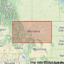
Mapped; occurs only as a few isolated erosional remnants unconformably overlying Precambrian rocks in Bighorn Mountains, Washakie (Bighorn basin) and Johnson (Powder River basin) Cos, WY in southwest part of study area. Described as buff to tan, very fine grained, poorly bedded sandstone; includes some interbedded siltstone and limestone. Predominantly of eolian and volcanic origin. Poorly indurated conglomerate derived from Precambrian rocks occurs locally near base. Thickness generally less than 200 ft. Younger than White River Formation (Oligocene); older than unnamed upper Miocene conglomerates. Assigned early Miocene age based on vertebrate fossils [unspecified].
Source: GNU records (USGS DDS-6; Denver GNULEX).
- Usage in publication:
-
- Arikaree Group*
- Modifications:
-
- Mapped 1:250k (Scottsbluff quad, NE)
- Dominant lithology:
-
- Siltstone
- Sandstone
- Conglomerate
- Volcaniclastics
- AAPG geologic province:
-
- Denver basin
- Chadron arch
Summary:
Mapped as lower Miocene and upper Oligocene group in western NE (Denver basin and Chadron arch). Divided into three major units (not separately mapped, though separately described) (descending): informal Camp Clarke unit (lower Miocene) of Swinehart and Diffendal (in press, USGS Map I-2496); Harrison (lower Miocene) and Monroe Creek (upper Oligocene) Formations, undivided; and Gering Formation (upper Oligocene). Camp Clarke consists of sandy siltstone and silty sandstone, volcaniclastic; in lower part, consists of informal Indian Creek beds of Swinehart and Diffendal (in press) of sandstone, siltstone, and claystone; and conglomerate, gravel, and sand. Harrison and Monroe Creek consist of silty sand and silty fine sandstone; volcaniclastic. Gering is fine- to medium-grained sandstone, silty sandstone, and sandy siltstone; volcaniclastic. Overlies Brule Formation (lower Oligocene) of White River Group (lower Oligocene and upper Eocene); underlies Ogallala Group (upper and middle Miocene).
Source: GNU records (USGS DDS-6; Denver GNULEX).
- Usage in publication:
-
- Arikaree Formation*
- Modifications:
-
- Mapped 1:500k
- Dominant lithology:
-
- Sandstone
- Volcanic ash
- AAPG geologic province:
-
- Powder River basin
Summary:
Pg. 11, geol. map, corr. chart. Arikaree Formation. Greenish gray, fine-grained sandstone with interbedded light-gray volcanic ash. Nonmarine to possibly marine-influenced. Thickness as much as 80 m (262 feet). Age is middle Oligocene (Arikareean NALMA).
[Notable exposures near Ekalaka and Capitol, Carter Co., eastern MT.]
Source: Publication.
For more information, please contact Nancy Stamm, Geologic Names Committee Secretary.
Asterisk (*) indicates published by U.S. Geological Survey authors.
"No current usage" (†) implies that a name has been abandoned or has fallen into disuse. Former usage and, if known, replacement name given in parentheses ( ).
Slash (/) indicates name conflicts with nomenclatural guidelines (CSN, 1933; ACSN, 1961, 1970; NACSN, 1983, 2005, 2021). May be explained within brackets ([ ]).