The National Geologic Map Database is migrating to a new infrastructure. We apologize for any service disruptions during this process.
|
|---|


- Usage in publication:
-
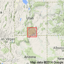
- Tropic shale*
- Modifications:
-
- Named
- Dominant lithology:
-
- Shale
- AAPG geologic province:
-
- Paradox basin
- Plateau sedimentary province
Summary:
Named for excellent exposures around the town of Tropic in Garfield Co, UT in the Paradox basin. Formation extends south into adjoining Kane Co, UT in the Plateau sedimentary province. No type locality designated. Geologic map. Maximum observed thickness is 1,450 ft. Partial section measured in sec 12, T38S, R4W where Tropic is 251 ft thick and overlies the Dakota? sandstone. Lower contact in measured section is a gray shale (Tropic) over yellow, white, hard massive sandstone (Dakota). Average thickness is about 600 ft. Forms broad bench or broad, gently undulating flats. Consists of uniform dark, drab clayey shale and fine-textured, thinly laminated, soft sandy shale. Includes some brown, friable, evenly bedded sandstone. Underlies Straight Cliffs sandstone. Upper contact in measured section is a gray shale (Tropic) overlain by yellow-gray sandstone (Straight Cliffs). Marine fossils (listed)--oysters--common in lower part. Fossils are rare or absent in middle and upper parts. Of Late Cretaceous age.
Source: GNU records (USGS DDS-6; Denver GNULEX).
- Usage in publication:
-
- Tropic Shale*
- Modifications:
-
- Contact revised
- AAPG geologic province:
-
- Plateau sedimentary province
Summary:
Upper contact revised. Is a slope-forming unit overlain by a cliff-forming sandstone belonging to the newly named Tibbet Canyon Member of Straight Cliffs Formation in Plateau sedimentary province. Assigned early Turonian (Late Cretaceous) age.
Source: GNU records (USGS DDS-6; Denver GNULEX).
- Usage in publication:
-
- Tropic Shale*
- Modifications:
-
- Age modified
- Biostratigraphic dating
- AAPG geologic province:
-
- Paradox basin
Summary:
Age is refined to early Turonian (Late Cretaceous) on basis of the ammonite WATINOCERAS DEVONENSE FLEXUOSUM n. subsp. identified from USGS Mesozoic locality D12623 from limestone concretion collected northeast of Henrieville, Garfield Co, UT, Paradox basin. Fauna places it within the middle zone of tripartite ammonite zonation of early Turonian. Paratypes of same subspecies noted to occur near base of middle third of Bridge Creek Limestone (bed 97 of Cobban and Scott, 1972, p. 23) of Greenhorn Limestone in Pueblo area of southeastern CO.
Source: GNU records (USGS DDS-6; Denver GNULEX).
- Usage in publication:
-
- Tropic Shale*
- Modifications:
-
- Biostratigraphic dating
- AAPG geologic province:
-
- Plateau sedimentary province
- Paradox basin
Summary:
Is formation in south-central UT. Is assigned a latest Cenomanian (Late Cretaceous) age based on presence of the ammonite NEOCARDIOCERAS JUDDII. Taxon occurs at USGS Mesozoic localities D12493, 7.5 m above base of unit, Garfield Co, UT in Paradox basin; D5268, 11 m above base, Kane Co, UT in Plateau sedimentary province; and D12356, 5.5 m above base, Kane Co, UT. Is assigned to latest Cenomanian N. JUDDII zone.
Source: GNU records (USGS DDS-6; Denver GNULEX).
For more information, please contact Nancy Stamm, Geologic Names Committee Secretary.
Asterisk (*) indicates published by U.S. Geological Survey authors.
"No current usage" (†) implies that a name has been abandoned or has fallen into disuse. Former usage and, if known, replacement name given in parentheses ( ).
Slash (/) indicates name conflicts with nomenclatural guidelines (CSN, 1933; ACSN, 1961, 1970; NACSN, 1983, 2005, 2021). May be explained within brackets ([ ]).