


- Usage in publication:
-
- Pryor conglomerate member
- Modifications:
-
- Overview
- Revised
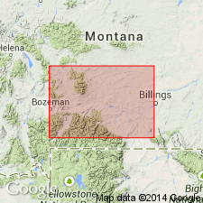
- Areal extent
- AAPG geologic province:
-
- Bighorn basin
Summary:
Is a distinctive basal conglomerate member of the Lower Cretaceous Cloverly formation present on the south and west flanks of the Pryor Mountains, Carbon Co, MT. Thins to southeast to a feather edge near Sykes Mountain, south of the Bighorn River in Big Horn Co, WY in the Bighorn basin. South of Sykes Mountain, its black chert pebbles and sand decrease in volume and grain size. At its southern extent, Pryor is a thin, well-sorted quartz arenite that interfingers with the lowermost part of the Little Sheep mudstone member (new) of the Cloverly. Unconformably overlies Morrison formation. Consists of conglomerate of rounded black chert pebbles to angular sand- and grit-size grains. Some plant fossils. Of Early Cretaceous age. Nomenclature chart. Cross section.
Source: GNU records (USGS DDS-6; Denver GNULEX).
- Usage in publication:
-
- Pryor Conglomerate Member*
- Modifications:
-
- Revised
- AAPG geologic province:
-
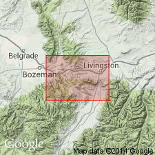
- Montana folded belt
- Central Montana uplift
- Powder River basin
Summary:
Newly assigned to Kootenai Formation as its lower member in Livingston area, Park Co, MT, Montana folded belt province. Is basal member of Cloverly Formation east of Livingston in Central Montana uplift and Powder River basin. Is 24 to 37 ft thick. Base marked by a massive bed of indurated chert pebbles. Overlies Morrison Formation; underlies upper part of Kootenai. Of Early Cretaceous, Aptian age.
Source: GNU records (USGS DDS-6; Denver GNULEX).
- Usage in publication:
-
- Pryor Conglomerate Member*
- Modifications:
-
- Overview
- AAPG geologic province:
-
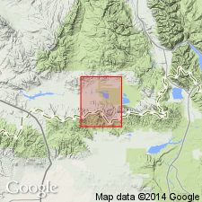
- Montana folded belt
Summary:
Three sections measured. At the first in NE1/4 sec 25, T2S, R6E, Gallatin Co, MT, Montana folded belt province, designated the reference section of the Kootenai, the Pryor is 37 ft thick and is described as a poorly bedded, cross-bedded to massive conglomerate and conglomeratic sandstone. The pebbles are dominantly chert and some are quartz. Is 24 ft thick and of same general character in two sections, one measured in NW1/4 sec 22, T3S, R9E, Park Co, MT, Montana folded belt province, and the other in sec 35, T2S, R9E, Park Co, MT, Montana folded belt province. Overlies Morrison Formation. Underlies upper part of Kootenai. Correlates with Cut Bank (base) and Sunburst Sandstone (middle) Members of Kootenai of Sweetgrass arch. Of Early Cretaceous, Aptian age. Correlation chart.
Source: GNU records (USGS DDS-6; Denver GNULEX).
- Usage in publication:
-
- Pryor Conglomerate Member*
- Modifications:
-
- Areal extent
- AAPG geologic province:
-
- Montana folded belt
- Snake River basin
Summary:
Kootenai Formation mapped at southeast edge of mapped area in Beaverhead and Madison Cos, MT in the Montana folded belt province, and in Clark Co, ID in the Snake River basin. The formation consists of the Pryor Conglomerate Member at base, a unit of conglomerate and conglomeratic, salt-and-pepper sandstone 8 m thick; a middle light-gray marly limestone and claystone unit about 148 m thick; and an upper light-gray limestone-claystone bed about 2 m thick that has coiled gastropod molds. Assigned to the Early Cretaceous.
Source: GNU records (USGS DDS-6; Denver GNULEX).
For more information, please contact Nancy Stamm, Geologic Names Committee Secretary.
Asterisk (*) indicates published by U.S. Geological Survey authors.
"No current usage" (†) implies that a name has been abandoned or has fallen into disuse. Former usage and, if known, replacement name given in parentheses ( ).
Slash (/) indicates name conflicts with nomenclatural guidelines (CSN, 1933; ACSN, 1961, 1970; NACSN, 1983, 2005, 2021). May be explained within brackets ([ ]).