

- Usage in publication:
-
- Marcellus Shale*
- Modifications:
-
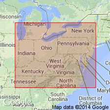
- Areal extent
- AAPG geologic province:
-
- Appalachian basin
Summary:
Marcellus Shale shown in figure 2 as being present in TN, KY, and OH.
Source: GNU records (USGS DDS-6; Reston GNULEX).
- Usage in publication:
-
- Marcellus Shale
- Modifications:
-
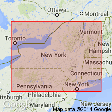
- Overview
- AAPG geologic province:
-
- Appalachian basin
Summary:
As restricted herein, the Tioga Bentonite is at a constant stratigraphic horizon in the eastern U.S. and in southern Ontario. This position is very near, or sometimes at, the base of the Cazenovian Marcellus Shale and its correlatives. It is not found in the Onondaga Limestone near the Seneca-Moorehouse boundary as previously thought. This bentonite near the top of the Moorehouse Member is herein named the Onondaga Indian Nation Bentonite. Therefore, the Seneca Member and the Marcellus Shale are separate and distinct and are not facies of one another. The Seneca is late Onesquethawan and the Marcellus is Cazenovian. In southern IN, the Tioga is near the base of the Speeds Limestone; in central OH, it is near the base of the Dublin "Shale" of the Delaware Formation; in NY, it is near the base of the Union Springs Member or the correlative Bakoven Member of the Marcellus; and in PA, it is near the base of the Marcellus.
Source: GNU records (USGS DDS-6; Reston GNULEX).
- Usage in publication:
-
- Marcellus Shale
- Modifications:
-
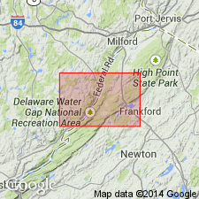
- Overview
- AAPG geologic province:
-
- Appalachian basin
Summary:
Marcellus Shale is mapped in northwestern NJ. Unit is dark-gray to black shale, locally arenaceous, and weathers medium-gray. Shale is fissile, predominantly thin-bedded, locally thick-bedded and massive, limonite-stained, and fossiliferous. Upper contact with the Mahantango Formation not exposed but regionally is gradational, spanning several feet and marked by a fairly abrupt change from lighter colored, harder, siltstone to darker colored, softer, silty shale. Thickness is approximately 900 ft. Lower contact with Buttermilk Falls Limestone covered but probably an abrupt change from black shale to silty limestone. Age is Middle Devonian.
Source: GNU records (USGS DDS-6; Reston GNULEX).

- Usage in publication:
-
- Marcellus Shale*
- Modifications:
-
- Areal extent
- AAPG geologic province:
-
- Appalachian basin
Summary:
Marcellus Shale of the Hamilton Group is the oldest of the extensive black gas shales. Unit crops out in the Valley and Ridge from southeastern NY to northern WV. The Marcellus or its partial equivalent the Millboro Shale, is present in the subsurface in NY, PA, OH, western MD, VA, WV, and northeastern TN. Consists for the most part of sooty black shale and a few beds of medium-gray shale and limestone nodules or beds of dark gray to black limestone. Marcellus is approximately 1,000 ft thick in central PA, but thins to the north, west, and south. Feathers out in eastern OH, western WV, and southwestern VA. The Cherry Valley Limestone Member is an extensive unit in the subsurface of NY, PA, and WV.
Source: GNU records (USGS DDS-6; Reston GNULEX).

- Usage in publication:
-
- Marcellus Shale*
- Modifications:
-
- Biostratigraphic dating
- AAPG geologic province:
-
- Appalachian basin
Summary:
Conodont biostratigraphy indicates that the Marcellus Shale is of Middle Devonian (Eifelian) age. Conodonts from the PO. C. COSTATUS Zone were recovered from the Tioga Ash Bed at the base of the formation and late Eifelian conodonts were recovered near the top of the formation.
Source: GNU records (USGS DDS-6; Reston GNULEX).

- Usage in publication:
-
- Marcellus subgroup [informal]
- Modifications:
-
- Revised
- AAPG geologic province:
-
- Appalachian basin
Summary:
Marcellus Formation will be "formally" raised to subgroup status within the Hamilton Group and be divided into a lower Union Springs Formation and an upper Mount Marion Formation (in eastern New York) and an upper Oatka Creek Formation (in central and western New York) in a publication by Ver Straeten and others (in prep).
["Subgroup" not recognized as a formal stratigraphic rank term (CSN, 1933; ACSN, 1961, 1970; NACSN, 1983, 2005, 2021). Considered informal and should not be capitalized.]
Source: Modified from GNU records (USGS DDS-6; Reston GNULEX).
For more information, please contact Nancy Stamm, Geologic Names Committee Secretary.
Asterisk (*) indicates published by U.S. Geological Survey authors.
"No current usage" (†) implies that a name has been abandoned or has fallen into disuse. Former usage and, if known, replacement name given in parentheses ( ).
Slash (/) indicates name conflicts with nomenclatural guidelines (CSN, 1933; ACSN, 1961, 1970; NACSN, 1983, 2005, 2021). May be explained within brackets ([ ]).