The National Geologic Map Database is migrating to a new infrastructure. We apologize for any service disruptions during this process.
|
|---|


- Usage in publication:
-
- Encrinital limestone
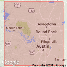
- Marble Falls limestone
- Modifications:
-
- Original reference
- Dominant lithology:
-
- Limestone
- AAPG geologic province:
-
- Llano uplift
- Ouachita folded belt
Summary:
Pg. 289. Encrinital limestone or Marble Falls limestone. Basal formation of Carboniferous in Burnet and Travis Counties, central Texas. Thickness 500 feet. Overlies Silurian and underlies 300 feet of Carboniferous bituminous shales and sandstones at Marble Falls and Smithwick. Age is Pennsylvanian (Pottsville).
Source: US geologic names lexicon (USGS Bull. 896, p. 1295).
- Usage in publication:
-
- Marble Falls limestone
- Modifications:
-
- Overview
- AAPG geologic province:
-
- Llano uplift
Summary:
Pg. 87-96. Marble Falls limestone. Shaly fossiliferous limestone, 300 feet thick. Is basement limestone over which the river falls at Marble Falls [Burnet County, Texas]. Age is Pennsylvanian (Pottsville).
Source: US geologic names lexicon (USGS Bull. 896, p. 1295).
- Usage in publication:
-
- Marble Falls limestone*
- Modifications:
-
- Revised
- AAPG geologic province:
-
- Llano uplift
Summary:
Marble Falls limestone. Alternating limestones of dark-gray, light-gray, dove, and dark-blue to black color. Petroliferous. Many beds contain abundant cherty nodules, largely dark or black. The bottom is in most places marked by a thin limestone conglomerate and in one place by a very coarse angular conglomerate or breccia, but there are localities where little or no discordance in sedimentation could be observed. At Marble Falls it includes at top 20 feet of thin-bedded black shale underlying the soft Smithwick shale. Thickness 250 to 450 feet. Underlies Smithwick shale and unconformably overlies Ellenburger limestone (Ordovician and Cambrian). Assigned to Pennsylvanian (Pottsville). Is younger than the Mississippian shale included in Bend series of Texas Survey [and later named Barnett shale].
Measured sections: (1) 368 feet thick, on north bank of Colorado River above bridge at Marble Falls, south-central Burnet quadrangle, Burnet Co., TX; (2) 248+ feet thick, in Riley Mountains, southeastern Llano quadrangle, TX.
Source: US geologic names lexicon (USGS Bull. 896, p. 1295); supplemental information from GNU records (USGS DDS-6; Denver GNULEX).

- Usage in publication:
-
- Marble Falls limestone
- Modifications:
-
- Revised
- AAPG geologic province:
-
- Llano uplift
- Bend arch
- Strawn basin
- Fort Worth syncline
Summary:
Pg. 25, 26; Univ. Texas Bull., no. 2132. Marble Falls limestone of Bend group. Exposures average 400 to 500 feet thick. Overlies Barnett shale (Mississippian), except at type locality [Burnet Co., central Texas] where it overlies Ordovician Ellenburger limestone. Underlies Smithwick shale of Bend group. Encountered in subsurface as far north as Red River and as far east as Fort Worth. Age is Early Pennsylvanian (early Pottsville). Fossils listed and discussed.
Source: US geologic names lexicon (USGS Bull. 896, p. 1295); supplemental information from GNU records (USGS DDS-6; Denver GNULEX).
- Usage in publication:
-
- Marble Falls limestone*
- Modifications:
-
- Mapped
Summary:
Marble Falls limestone, lower formation in Bend group; underlies Smithwick shales.
Source: US geologic names lexicon (USGS Bull. 1200, p. 2371-2372).

- Usage in publication:
-
- Marble Falls group
- Modifications:
-
- Revised
- Redescribed
- AAPG geologic province:
-
- Llano uplift
- Bend arch
Summary:
Pg. 66 (fig. 1), 80. Marble Falls group. In this report, type Marble Falls beds are considered a group, being part of Morrow series. Underlies Big Saline group of Lampasas series (both new). Big Saline beds have commonly been included with the Marble Falls. In Ranger area, beds previously assigned to Marble Falls are reallocated to Comyn formation (new); in McCulloch and Kimble Counties, "Marble Falls" beds are believed to be post-Morrow. Age is Early Pennsylvanian (Morrow). Report includes stratigraphic chart.
Source: US geologic names lexicon (USGS Bull. 1200, p. 2371-2372); supplemental information from GNU records (USGS DDS-6; Denver GNULEX).
- Usage in publication:
-
- Marble Falls limestone
- Modifications:
-
- Revised
Summary:
Pg. 3, 5, 6, 8. Marble Falls limestone includes [sequence not stated] Lemmons Bluff (new), Big Saline, and Sloan (new) members.
Source: US geologic names lexicon (USGS Bull. 1200, p. 2371-2372).
- Usage in publication:
-
- Marble Falls limestone
- Modifications:
-
- Revised
- AAPG geologic province:
-
- Llano uplift
Summary:
Pg. 64-69. Marble Falls limestone. Consists generally of dark-gray and black siliceous fossiliferous limestones and black shales; upper limestones grade eastward into shales. Thickness 30 to more than 400 feet. Divided into four units (ascending): Lemons Bluff member, Big Saline member, Sloan member, and Gibbons conglomerate lentil (new). Underlies Smithwick shale; overlies Barnett formation in some places and in others the Ellenburger. [Age is Early Pennsylvanian.]
Source: US geologic names lexicon (USGS Bull. 1200, p. 2371-2372).
- Usage in publication:
-
- Marble Falls limestone
- Modifications:
-
- Revised
- Age modified
- AAPG geologic province:
-
- Llano uplift
Summary:
Pg. 181-183. Marble Falls limestone. Presence of fusiform fusulinids in Marble Falls limestone indicates that formation is post-Morrow in age. If Morrow beds are present at all in type Marble Falls, only a small part of lower part could be so classified, and, until some evidence of its Morrow equivalence is found, beds at Marble Falls should be regarded as post-Morrow in age. Term Marble Falls should be restored to its former meaning; that is, to include all beds at Marble Falls and equivalent beds in other parts of central Texas. Included in Atoka series. Age is Middle Pennsyvlanian.
Source: US geologic names lexicon (USGS Bull. 1200, p. 2371-2372).
- Usage in publication:
-
- Marble Falls limestone
- Modifications:
-
- Not used
- AAPG geologic province:
-
- Llano uplift
Summary:
Pg. 142-146. Big Saline formation east of Cavern Ridge comprises (ascending) Gibbons conglomerate, Aylor oolite, Lemons Bluff spiculite, and Brister limestone members. Term Big Saline limestone as used east of Cavern Ridge includes the type section of the Marble Falls limestone and other sections of the Marble Falls limestone east of Cavern Ridge discussed by Thompson (1947, Jour. Paleo., v. 21, no. 2, p. 147-164). Age is Early Pennsylvanian.
Source: US geologic names lexicon (USGS Bull. 1200, p. 2371-2372).
- Usage in publication:
-
- Marble Falls group
- Modifications:
-
- Revised
- AAPG geologic province:
-
- Llano uplift
Summary:
Pg. 46-77. Marble Falls group. Comprises Sloan formation below and Big Saline formation above. Underlies Smithwick formation.
Source: US geologic names lexicon (USGS Bull. 1200, p. 2371-2372).
For more information, please contact Nancy Stamm, Geologic Names Committee Secretary.
Asterisk (*) indicates published by U.S. Geological Survey authors.
"No current usage" (†) implies that a name has been abandoned or has fallen into disuse. Former usage and, if known, replacement name given in parentheses ( ).
Slash (/) indicates name conflicts with nomenclatural guidelines (CSN, 1933; ACSN, 1961, 1970; NACSN, 1983, 2005, 2021). May be explained within brackets ([ ]).