The National Geologic Map Database is migrating to a new infrastructure. We apologize for any service disruptions during this process.
|
|---|


- Usage in publication:
-
- Leatham formation
- Modifications:
-
- Named
- Dominant lithology:
-
- Shale
- Limestone
- Siltstone
- AAPG geologic province:
-
- Wasatch uplift
Summary:
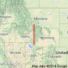
Named for exposures on north wall of Leatham Hollow, 3/4 mi west of Left Fork of Blacksmith Fork at northwest corner sec 34, T11N, R2E, Cache Co, UT on Wasatch uplift. Known in northeastern UT and southeastern ID. [The exposures in Leatham Hollow inferred to be type section on p. 1719; term type locality used on p. 1720.] Is composed of dark-gray, brown, sandy to silty shale, medium-dark-gray, finely crystalline, thin-bedded, fossiliferous limestone, and brownish-gray shaly sandstone. Limestone can be nodular, and some beds have pyrite crystals. Uppermost 2 ft of the Jefferson is a dark-gray to brownish-gray, hard, dense, silty limestone called the "Contact Ledge". Is 76 ft thick at type. Unconformably overlies Jefferson formation; overlain conformably by Madison formation. Is fossiliferous. Assigned to Kinderhookian, or Early Mississippian. Is correlative of Sappington sandstone of southwest MT.
Source: GNU records (USGS DDS-6; Denver GNULEX).
- Usage in publication:
-
- Leatham Formation*
- Modifications:
-
- Age modified
- AAPG geologic province:
-
- Wasatch uplift
- Green River basin
Summary:
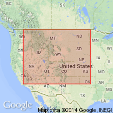
Evidence for Mississippian age of Leatham Formation has not been found. Age designation used in this report is Late Devonian (Famennian) and Mississippian?. This is a slight change from the previous designation of Late Devonian and Early Mississippian. At type: divided into 7 units; units 1 to 6 are Famennian; unit 7 at top revised. A 2.5 m shale above an unconformity formerly within unit 7 is reassigned to the overlying Cottonwood Canyon Member of the Lodgepole Limestone. The revised (or lower part of the original) unit 7 is in an unzoned conodont interval. Unconformably overlies the Beirdneau Formation at the type. Occurs in a small area in southwest WY (Greater Green River basin), northern UT and southeast ID (Wasatch uplift). Lithofacies maps; columnar section.
Source: GNU records (USGS DDS-6; Denver GNULEX).
- Usage in publication:
-
- Leatham Member*
- Modifications:
-
- Principal reference
- Revised
- Dominant lithology:
-
- Mudstone
- Siltstone
- Limestone
- Shale
- AAPG geologic province:
-
- Great Basin province
Summary:
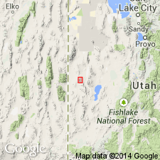
Geographically extended to Confusion Range, Millard Co, UT in the Great Basin province, where it is reduced in stratigraphic rank from Leatham Formation to Leatham Member, middle member of the Pilot Shale. Section measured in Little Mile-and-a-Half Canyon, N1/2 sec 29, T18S, R16W, in the Confusion Range, is designated the principal reference section. Is 15 to 59 ft thick. Is divisible at principal reference section into a lower unit, a deep water organic-rich mudstone and siltstone (13.1-25.3 ft thick), that is partly chertified and has large coarsely crystalline limestone concretions with conodonts, and an upper unit, a shallow water deposit (1.9-33.7 ft thick), that consists of thin lag sandstone, shale, silty oncolite-bank limestone, and a regressive bioturbated brachiopod-bearing siltstone. Unconformably overlies lower member of Pilot. Underlies upper member of Pilot. Columnar section. Of Late Devonian, Famennian age. Correlates with Sappington Member of Three Forks Formation of MT.
Source: GNU records (USGS DDS-6; Denver GNULEX).
For more information, please contact Nancy Stamm, Geologic Names Committee Secretary.
Asterisk (*) indicates published by U.S. Geological Survey authors.
"No current usage" (†) implies that a name has been abandoned or has fallen into disuse. Former usage and, if known, replacement name given in parentheses ( ).
Slash (/) indicates name conflicts with nomenclatural guidelines (CSN, 1933; ACSN, 1961, 1970; NACSN, 1983, 2005, 2021). May be explained within brackets ([ ]).