


- Usage in publication:
-
- Grove Creek member
- Modifications:
-
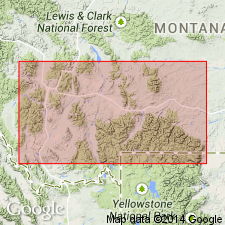
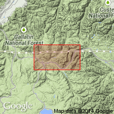
- Areal extent
- AAPG geologic province:
-
- Bighorn basin
- Wind River basin
Summary:
Pg. 1092-1093, 1101 (fig. 3), 1105. Grove Creek member of Boysen formation. [Grove Creek formation of Dorf and Lochman, 1938 (abs.) and 1940; see 1940 entry] reduced to member status in Boysen formation (new) in Wind River area, Wyoming. Uppermost member of formation; overlies Snowy Range member. Thickness 40 feet in type section of Boysen. [Age is Late Cambrian (Trempealeau) based on trilobites.]
Source: US geologic names lexicon (USGS Bull. 1200, p. 1623-1624).
- Usage in publication:
-
- Grove Creek formation
- Modifications:
-
- Named
- Dominant lithology:
-
- Conglomerate
- Shale
- Dolomite
- AAPG geologic province:
-
- Montana folded belt
- Central Montana uplift
- Bighorn basin
- Yellowstone province
Summary:
Name proposed for the uppermost of three newly named Upper Cambrian units which outcrop in Snowy and Beartooth Mountains, along eastern front of Absaroka Mountains as far south as Shoshone River, and as far west as Gallatin Range and northwest Yellowstone Park (Montana folded belt province, Central Montana uplift, Bighorn basin, and Yellowstone province). Divided into: lower member of predominantly limestone pebble conglomerate with minor shale and limestone; and upper member of shales and platy dolomites. Lower member characterized by well-rounded, greenish-coated limestone pebbles, many with holes worn through center, and large star-shaped crinoid stems. Upper member has characteristic yellow to orange color. Thickness ranges from 20 to 47 feet, averaging 35 feet. Conformably overlies Snowy Range formation (new); unconformably underlies Bighorn dolomite. Is equivalent to Jordan member of Trempealeau formation in Wisconsin and may be in part correlative with Saint Lawrence member of Trempealeau. Upper member contains sporadic trilobite fauna of EUREKIA zone. Age is Late Cambrian. Report includes columnar sections with faunal zones, measured section.
Type locality: on south wall of valley of North Fork of Grove Creek, Carbon Co., MT. Named from tributary of Clark [Clarks] Fork of Yellowstone River, Carbon Co., MT.
Source: Modified from GNU records (USGS DDS-6; Denver GNULEX).
- Usage in publication:
-
- Grove Creek formation
- Modifications:
-
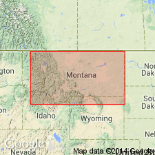
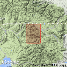
- Areal extent
- AAPG geologic province:
-
- Montana folded belt
- Bighorn basin
Summary:
Grove Creek formation. Extends from Cooke City area, southeast Park County, Montana, southward into northern Park County, Wyoming. Thickness at Cooke City, Wyoming, 20 feet, and at Beartooth Butte, Wyoming, 7 feet. Conformably overlies Snowy Range formation; unconformably underlies Big Horn dolomite. Correlates with upper part of St. Charles formation of northeast Utah and in part with uppermost part of Gallatin formation of northwest Wyoming. Age is Late Cambrian (Trempealeauan). Report includes measured sections, cross section, correlation chart, isopach map of combined Grove Creek, Snowy Range, and Red Lion formations.
Source: Modified from GNU records (USGS DDS-6; Denver GNULEX).
- Usage in publication:
-
- Grove Creek limestone
- Modifications:
-
- Age modified
- AAPG geologic province:
-
- Bighorn basin
- Powder River basin
Summary:
Uses name "Grove Creek" in Pryor and northern Bighorn Mountains (Bighorn and Powder River basins). Author states that "Grove Creek," as defined by Dorf and Lochman (1940), is not suitable as a time-rock unit (Trempealeauan equivalent) and is used in this report in a lithic sense. Overlies Gros Ventre formation. Durkee (1953, unpub. thesis, Univ. Wyoming) reports SYMPHYSURINA, indicative of earliest Ordovician, at 146 and 149 feet above the base of "Grove Creek" in a section on Little Tongue River, Sheridan County, Wyoming. This is first reported occurrence of Lower Ordovician rocks in Bighorn Mountains. Age is Late Cambrian and Early Ordovician.
Source: Modified from GNU records (USGS DDS-6; Denver GNULEX).
- Usage in publication:
-
- Grove Creek limestone member, pebble conglomerate member
- Modifications:
-
- Revised
- Redescribed
- Dominant lithology:
-
- Conglomerate
- Limestone
- AAPG geologic province:
-
- Montana folded belt
- Yellowstone province
- Bighorn basin
- Wind River basin
Summary:
Reduced in rank, assigned to Snowy Range formation as uppermost member (of 3). Maximum thickness is 50 feet. Remnants are exposed from Gallatin Range southeast through Shoshone Canyon to Wind River Canyon in Bridger Mountains, Wyoming, within Montana folded belt province, Yellowstone province, Bighorn basin and Wind River basin. Lower part consists of thick-bedded limestone pebble conglomerates interbedded with few thin shales and limestones. Upper part consists of platy arenaceous dolomite, limy siltstones, and pure fossiliferous limestones intercalated with varying amounts of shale. Several fossils of SAUKIA faunizone present. Overlies Sage pebble conglomerate member of Snowy Range; unconformably underlies Bighorn [dolomite]. Age is Late Cambrian.
Source: GNU records (USGS DDS-6; Denver GNULEX).
- Usage in publication:
-
- Grove Creek formation*
- Modifications:
-
- Overview
- AAPG geologic province:
-
- Montana folded belt
Summary:
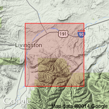
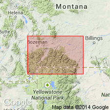
Grove Creek formation mapped with Snowy Range formation in area of Livingston, Park County, Montana (Montana folded belt province). [This revision from member to formation rank not discussed]. Unit is 50 feet thick and consists of predominantly conglomeratic limestone and shale with some stringers of sandstone and siltstone. Some limestone pebbles are rounded and some are flat. Overlies Snowy Range formation; unconformably underlies Bighorn Dolomite. Age is Late Cambrian. Report includes geologic map, columnar section, measured section.
Source: Modified from GNU records (USGS DDS-6; Denver GNULEX).
- Usage in publication:
-
- Grove Creek Member
- Modifications:
-
- Overview
- AAPG geologic province:
-
- Montana folded belt
- Central Montana uplift
- Bighorn basin
- Yellowstone province
Summary:
Snowy Range Formation measured at 24 locations in Horseshoe Hills and Bridger Mountains, Montana, and at 8 locations near Yellowstone National Park, between Missouri River and Clarks Fork of Yellowstone River, in Gallatin, Park, and Carbon Counties, Montana, and Park County, Wyoming (Montana folded belt province, Central Montana uplift, Bighorn basin, and Yellowstone province). Snowy Range divided into (ascending) Dry Creek, Sage, and Grove Creek Members. Grove Creek is thinnest of three members due to pre-Late Devonian erosion. It is present at only one locality in Horseshoe Hills where it is 48 feet thick; in Bridger Mountains, its thickness ranges from 6 to 44 feet; it is absent between Bridger Mountains and Mill Creek and at Crowfoot Ridge; at Mill Creek and Upper Fox Creek, it is 15 feet thick; and at North Grove Creek, it is 48 feet thick. Underlies either Maywood or Bighorn Formations. Where Maywood is overlying unit, Grove Creek is altered by weathering or truncated at top; where overlain by Bighorn, contact is sharp, usually due to faulting. Age is late Late Cambrian (Trempealeauan), based on trilobites and brachiopods. Report includes petrographic descriptions, fossil list and descriptions, cross sections showing trilobite zones.
Source: Modified from GNU records (USGS DDS-6; Denver GNULEX).
- Usage in publication:
-
- Grove Creek Formation*
- Modifications:
-
- Revised
- AAPG geologic province:
-
- Bighorn basin
Summary:
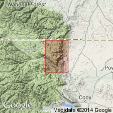
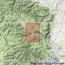
Assigned to Gallatin Group (rank raised) as its upper formation. Mapped with underlying Snowy Range Formation of Gallatin. Map covers part of Beartooth Mountains in northwest Wyoming (Bighorn basin). Unit is about 50 feet thick. Underlies Bighorn Dolomite. Age is Late Cambrian.
Source: GNU records (USGS DDS-6; Denver GNULEX).
- Usage in publication:
-
- Grove Creek Member*
- Modifications:
-
- Revised
- AAPG geologic province:
-
- Bighorn basin
Summary:
Grove Creek Member, upper member of Snowy Range Formation of Gallatin Group. Occurs in upper part of Snowy Range [no additional subdivisions of Snowy Range are made]. Mapped in area of Beartooth Mountains, in northwest Wyoming (Bighorn basin). Thickness is about 40 feet. Underlies Bighorn Dolomite. Age is Late Cambrian.
Source: Modified from GNU records (USGS DDS-6; Denver GNULEX).
- Usage in publication:
-
- Grove Creek Limestone Member*
- Modifications:
-
- Overview
- Reference
- AAPG geologic province:
-
- Yellowstone province
- Montana folded belt
Summary:
Grove Creek Limestone Member, top member of Snowy Range Formation. Mapped undivided with underlying Sage Limestone and Dry Creek Members, in northern part of Yellowstone National Park, Park County, Wyoming, and Park County, Montana. In study area, exposed only on Three Rivers Peak, where it is 40 feet thick. Also crops out south of Silver Gate, Montana, near Northeast Entrance to Park. Unconformably underlies Bighorn Dolomite. Age is Late Cambrian. Report includes stratigraphic chart.
Reference section (for Snowy Range Formation): Three Rivers Peak, at head of Gallatin River in Gallatin Range.
Source: Modified from GNU records (USGS DDS-6; Denver GNULEX).
- Usage in publication:
-
- Grove Creek Member*
- Modifications:
-
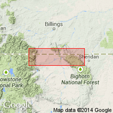
- Areal extent
- AAPG geologic province:
-
- Bighorn basin
- Yellowstone province
- Montana folded belt
Summary:
Is upper member of Snowy Range Formation of Gallatin Group. Extended into area around northeast boundary of Yellowstone National Park, Park County, Wyoming, and Park County, Montana (Yellowstone province, Bighorn basin, and Montana folded belt province). Thickness is about 40 feet. Underlies Bighorn Dolomite. Age is Late Cambrian.
Source: Modified from GNU records (USGS DDS-6; Denver GNULEX).
For more information, please contact Nancy Stamm, Geologic Names Committee Secretary.
Asterisk (*) indicates published by U.S. Geological Survey authors.
"No current usage" (†) implies that a name has been abandoned or has fallen into disuse. Former usage and, if known, replacement name given in parentheses ( ).
Slash (/) indicates name conflicts with nomenclatural guidelines (CSN, 1933; ACSN, 1961, 1970; NACSN, 1983, 2005, 2021). May be explained within brackets ([ ]).