

- Usage in publication:
-
- Fish Canyon Tuff*
- Modifications:
-
- Named
- Geochronologic dating
- Dominant lithology:
-
- Tuff
- AAPG geologic province:
-
- Piceance basin
Summary:
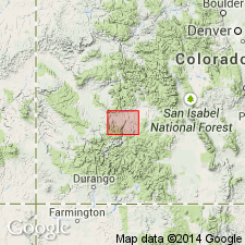
Named for exposures in Fish Canyon, its type locality, near south edge of Rudolph Hill quad, Gunnison Co, Co in Piceance basin. Pinches out west of Myers Gulch and is not shown in Montrose Co. Formerly called upper member of Alboroto Rhyolite of Potosi Volcanic Series by Larsen and Cross (1956). Consists of crystal-rich welded tuff that is light gray, buff, white and massive. Is nonwelded in upper part. Ranges from 0 (west edge of area) to 1,280 ft thick north of Fish Canyon. Overlies Sapinero Mesa Tuff (new name); underlies Carpenter Ridge Tuff (new name). Is a large ash-flow and air-fall sheet whose source was to the west. Biotite on sample on Sapinero Mesa has a K-Ar age of 27 +/-10 m.y. or late Oligocene.
Source: GNU records (USGS DDS-6; Denver GNULEX).
- Usage in publication:
-
- Fish Canyon Tuff*
- Modifications:
-
- Areal extent
- AAPG geologic province:
-
- San Juan Mountains province
Summary:
Is a crystal-rich quartz latite of normal magnetic polarity 27.8 m.y. K-Ar, or Oligocene age, that has an estimated original volume of 3,000+ cubic km and areal extent if 15,000 sq km in the Piceance basin and San Juan Mountain province. Was derived from the La Garita caldera. Is older than Crystal Lake Tuff (new).
Source: GNU records (USGS DDS-6; Denver GNULEX).
- Usage in publication:
-
- Fish Canyon Tuff*
- Modifications:
-
- Revised
- AAPG geologic province:
-
- Piceance basin
- San Juan Mountains province
- San Luis basin
Summary:
Pg. A77-A78. Fish Canyon Tuff. Erupted from the La Garita caldera near the center of the San Juan volcanic field. Present in Saguache and Rio Grande Counties (San Luis basin), in Mineral and Hinsdale Counties (San Juan Mountain province), and in Gunnison County (Piceance basin). Includes the intracaldera rocks previously assigned to the Alboroto Rhyolite† (herein abandoned) by Larsen and Cross (1956, USGS Prof. Paper 258, pl. 1); in outflow areas along north side of volcanic field, includes only the upper Alboroto of Larsen and Cross (1956, p. 137). Is a distinctive crystal-rich quartz latite ash-flow tuff; characterized by abundant phenocrysts of plagioclase, sanidine, quartz, biotite, and hornblende, and accessory mineral sphene. Is largest and most extensive ash-flow tuff in San Juan field; unit had an original area of at least 15,000 sq km, and a volume in excess of 3,000 cubic km. Includes (in ascending order) an outflow member, La Garita Member (revised), and Phoenix Park Member. Age is Oligocene (27.8 m.y.), based on K-Ar methods (citing Lipman and others, 1970, GSA Bull., v. 81, no. 8, p. 2339-2340).
Source: Publication.
- Usage in publication:
-
- Fish Canyon Tuff*
- Modifications:
-
- Overview
- AAPG geologic province:
-
- Piceance basin
- San Juan basin
- San Juan Mountains province
- San Luis basin
Summary:
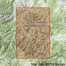
Erupted 27.8 m.y. ago from the La Garita caldera which is 35-40 km in diameter. Includes the intracaldera La Garita Member. Rests on Masonic Park Tuff and is overlain by Carpenter Ridge Tuff. Locally Huerto Andesite intervenes between Fish Canyon and Carpenter Ridge. Accumulated within the caldera complex in the low northeastern part of Platoro caldera moat. Is nearly 1 km thick in the headwaters of the South Fork of the Rio Grande where it forms a single thick cooling unit. Outside Mount Hope caldera it is typically 20-200 m thick. Is the most widespread (at least 15,000 sq km) and voluminous (more than 3,000 cubic km) single ash-flow sheet in the San Juan volcanic field. Detailed lithologic description. Areal extent map shows it in parts of San Juan Mountain province, San Juan basin, Piceance basin, and San Luis basin. Has normal remanent magnetic polarity.
Source: GNU records (USGS DDS-6; Denver GNULEX).

- Usage in publication:
-
- Fish Canyon Tuff*
- Modifications:
-
- Areal extent
- AAPG geologic province:
-
- Piceance basin
- San Juan basin
- San Juan Mountains province
- San Luis basin
Summary:
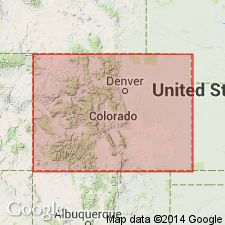
Areal extent of Fish Canyon Tuff in southwestern Colorado shown on distribution map; extends from Rio Grande and Saguache Counties, (San Luis basin) into Mineral and Hinsdale Counties (San Juan Mountain province), Archuleta County (San Juan basin), and Gunnison County (Piceance basin). Derived from the La Garita caldera, the largest caldera of the San Juan volcanic field and among the great calderas of the world. Had an estimated volume of more than 3,000 cubic km. Age is 27.8 m.y.
Source: Modified from GNU records (USGS DDS-6; Denver GNULEX).
- Usage in publication:
-
- Fish Canyon Tuff*
- Modifications:
-
- Geochronologic dating
- Overview
- AAPG geologic province:
-
- San Juan Mountains province
Summary:
Is ash-flow sheet within LaGarita caldera in central San Juan Mountains of CO, San Juan Mountain province. High-resolution 40/39 Ar geochronology (unpublished data, M. Lanphere, USGS) yields age of 27.75 Ma [late Oligocene].
Source: GNU records (USGS DDS-6; Denver GNULEX).
For more information, please contact Nancy Stamm, Geologic Names Committee Secretary.
Asterisk (*) indicates published by U.S. Geological Survey authors.
"No current usage" (†) implies that a name has been abandoned or has fallen into disuse. Former usage and, if known, replacement name given in parentheses ( ).
Slash (/) indicates name conflicts with nomenclatural guidelines (CSN, 1933; ACSN, 1961, 1970; NACSN, 1983, 2005, 2021). May be explained within brackets ([ ]).