

- Usage in publication:
-
- Curecanti granite*
- Modifications:
-
- Named
- Dominant lithology:
-
- Granite
- AAPG geologic province:
-
- Southern Rocky Mountain region
Summary:
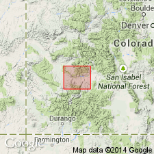
Named for exposures 3 1/2 mi along Black Canyon from a point 1 1/2 mi east of Curecanti Creek to Nelson Gulch, Montrose Co, CO in Southern Rocky Mountain region. No type locality designated. Contains many inclusions of biotite schist. Changes from granite with inclusions of schist to schist with many injections of granite is in many places imperceptible. Is pink to gray, fine-grained, even textured granite with chiefly quartz, microcline, and soda plagioclase with varying quantities orthoclase, muscovite, and biotite. Extends only a short distance up Curecanti Creek forming walls of lower canyon of Blue Creek for 1 1/2 mi from its mouth. Covers little more than 2 square mi. Western and southern limits uncertain. Intruded into Archean biotite schist. Overlain by sedimentary (Mesozoic) and volcanic (Tertiary) rocks. Assigned to pre-Cambrian.
Source: GNU records (USGS DDS-6; Denver GNULEX).
- Usage in publication:
-
- Curecanti Quartz Monzonite*
- Modifications:
-
- Redescribed
- Areal extent
- Overview
- Dominant lithology:
-
- Quartz monzonite
- AAPG geologic province:
-
- Southern Rocky Mountain region
Summary:
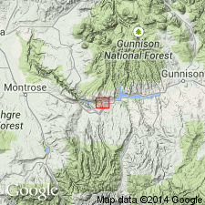
Redescribed as a pluton mainly of sodic quartz monzonite with a silica content close to an average granite. Occurs as a sublenticular body in Black Canyon of the Gunnison River. The Curecanti Needle 800 ft high about 4 1/2 mi downstream from Blue Mesa damsite near Sapinero, Gunnison Co, CO in Southern Rocky Mountain region, is designated the type locality. The pluton is 3 1/2 mi across west to east and 2 mi across north to south; is broadly horizontal; has subparallel upper and lower contacts; has shape of a flat laccolith or thick sill. Main body crops out at Curecanti Needle. Other smaller bodies crop out in adjacent parts of canyon. Geologic map. The country rock intruded by the pluton is migmatitic biotite-quartz-microcline-plagioclase-gneiss. Is overlain by Upper Jurassic rocks, or locally Tertiary volcanics. Has gray to pink, uniform texture, medium grain size, and allotriomorphic-granular texture. Chemical analyses, modal analyses. Principal minerals are sodic oligoclase, quartz, microcline. Is predominantly quartz monzonite. Some small bodies are granodiorite; some are diorite. Minor constituents are muscovite, biotite, hornblende. Traces of garnet, sphene, apatite, opaque minerals, zircon. Has a distinctive alaskite variant border phase. Has inclusions mostly of feldspathic quartz-biotite gneiss that range from a fraction of an inch across to several hundreds of ft. Precambrian age.
Source: GNU records (USGS DDS-6; Denver GNULEX).
- Usage in publication:
-
- Curecanti Granite*
- Modifications:
-
- Overview
- AAPG geologic province:
-
- Southern Rocky Mountain region
Summary:
Also called Curecanti Quartz Monzonite. Occurs in irregular pluton and in many small bodies in Gunnison River area, CO in Southern Rocky Mountain region. Probably present also in Unaweep Canyon in Uncompahgre Plateau. Listed with granitic rocks and gabbro of circa 1,400 m.y. (Precambrian Y) age group.
Source: GNU records (USGS DDS-6; Denver GNULEX).
- Usage in publication:
-
- Curecanti Quartz Monzonite*
- Modifications:
-
- Areal extent
- Overview
- AAPG geologic province:
-
- Southern Rocky Mountain region
Summary:
Is one of ten formally named lithodemic units assigned to the Middle Proterozoic Berthoud Plutonic Suite (a new name) in the Southern Rocky Mountain region. Forms a small pluton (a flat-lying, slightly domed, discordant sheet) in Black Canyon of the Gunnison River. Is partly exposed on Uncompahgre plateau. Pluton occupies an area of about 18 sq km (7 sq mi). Is a light-gray to pink, equigranular and medium-grained, sodic biotite muscovite quartz monzonite that grades into granodiorite locally. Whole rock Rb-Sr isochron plot indicates an age of 1,392 +/-15 m.y.
Source: GNU records (USGS DDS-6; Denver GNULEX).
For more information, please contact Nancy Stamm, Geologic Names Committee Secretary.
Asterisk (*) indicates published by U.S. Geological Survey authors.
"No current usage" (†) implies that a name has been abandoned or has fallen into disuse. Former usage and, if known, replacement name given in parentheses ( ).
Slash (/) indicates name conflicts with nomenclatural guidelines (CSN, 1933; ACSN, 1961, 1970; NACSN, 1983, 2005, 2021). May be explained within brackets ([ ]).