

- Usage in publication:
-
- Coeymans limestone
- Modifications:
-
- Revised
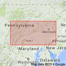
- Areal extent
- AAPG geologic province:
-
- Appalachian basin
Summary:
Coeymans limestone includes Stormville sandstone member (new) at top in Monroe Co., PA, and Elbow Ridge sandstone member (new) in Franklin Co., PA. Thicknesses are 40 ft at Nearpass quarries, NJ; 80 ft in Monroe Co., PA; 40 to 50 ft in Carbon Co., PA; 3 to 10 ft in central to south-central PA; and 50 to 55 ft near Monterey, VA. Overlies Keyser limestone; underlies New Scotland formation.
Source: GNU records (USGS DDS-6; Reston GNULEX).
- Usage in publication:
-
- Coeymans Formation*
- Coeymans Limestone*
- Modifications:
-
- Revised
- AAPG geologic province:
-
- Appalachian basin
Summary:
In report area, name changed from Coeymans Limestone to Coeymans Formation. Coeymans Formation (in New Jersey and Pennsylvania) includes (ascending): Depue Limestone (new), Peters Valley (new), Shawnee Island (new), and Stormville Members. Coeymans Limestone remains in good usage elsewhere. Coeymans Limestone (in eastern New York) includes Ravena Member. Age is Early Devonian.
Source: Changes in stratigraphic nomenclature, 1967 (USGS Bull. 1274-A, p. A5).
- Usage in publication:
-
- Coeymans Formation
- Modifications:
-
- Overview
- AAPG geologic province:
-
- Appalachian basin
Summary:
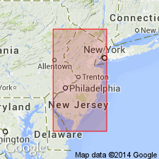
Coeymans Formation mapped in Sussex County, northwestern New Jersey. Includes Depue Limestone Member, Shawnee Island Member, and Stormville Member, though members are not separately mapped. Stormville is a medium-light to medium-gray, fine- to coarse-grained calcareous sandstone containing lenses of arenaceous limestone. Lower contact marked by scoured surface. Northeast of Wallpack Center, the Stormville member is replaced by the Kalkberg Limestone, a medium-bedded, medium-gray, medium-grained silty limestone with lenses and nodules of black chert. Southwest of Wallpack Center, the Kalkberg Limestone grades into the Shawnee Island Member, a medium-gray, medium- to coarse-grained limestone, medium-bedded, flaggy to massive, with local bioherms. Throughout the map area the basal Depue Limestone Member consists of medium-dark-gray, very fine- to fine-grained limestone, thin- to medium-bedded, massive to flaggy. Total thickness of all units approximately 90 feet. All units are fossiliferous. The lower contact of each member is gradational unless otherwise stated. Lower contact of formation with Rondout Formation is abrupt and marked by first occurrence of argillaceous limestone. Underlies New Scotland Formation. Age is Early Devonian.
Source: GNU records (USGS DDS-6; Reston GNULEX).
- Usage in publication:
-
- Coeymans Formation*
- Modifications:
-
- Age modified
- Biostratigraphic dating
- AAPG geologic province:
-
- Appalachian basin
Summary:
Age of Coeymans Formation refined to early Lochkovian. Contains conodont ICRIODUS WOSCHMIDTI, an auxiliary guide to base of Devonian.
Source: GNU records (USGS DDS-6; Reston GNULEX).
For more information, please contact Nancy Stamm, Geologic Names Committee Secretary.
Asterisk (*) indicates published by U.S. Geological Survey authors.
"No current usage" (†) implies that a name has been abandoned or has fallen into disuse. Former usage and, if known, replacement name given in parentheses ( ).
Slash (/) indicates name conflicts with nomenclatural guidelines (CSN, 1933; ACSN, 1961, 1970; NACSN, 1983, 2005, 2021). May be explained within brackets ([ ]).