The National Geologic Map Database is migrating to a new infrastructure. We apologize for any service disruptions during this process.
|
|---|


- Usage in publication:
-
- Capps limestone lentil
- Modifications:
-
- Original reference
- Dominant lithology:
-
- Limestone
- AAPG geologic province:
-
- Bend arch
Summary:
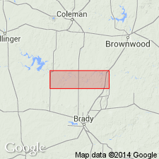
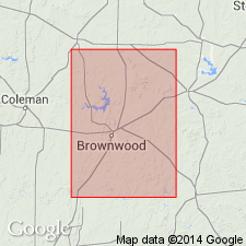
Pg. 24, 31; Univ. Texas Bull., no. 2132, p. 96, 97. Capps limestone lentil of Brownwood member of Graford formation of Canyon group. A thin lentil of limestone near base of Brownwood member of Graford formation in Brown County. Very irregular in lithologic character. In places almost nothing but corals; in other places composed of rounded limestone and chert pebbles cemented by calcareous carbonate to form a solid limestone layer. Is "Coral" limestone of Drake (1893), so named on account of its very abundant and characteristic corals, chiefly CHAETETES. Thickness 4 feet. Is traceable for only short distances on either side of Pecan Bayou. To northeast of Brownwood it extends from a point near Capps well to beyond Frisco RR, a total distance of about 3 miles. To southeast of Brownwood it is exposed from near Santa Fe tracks to Cretaceous overlap east of Cedarton. Typical exposure found west of schoolhouse, 2.5 mi southeast of Brownwood and 2 mi west of Pecan Bayou; consists of dense, dark gray-blue limestone filled with numerous CHAETETES, which on weathered surfaces give a knotted, gnarly appearance to the bed. East of Brownwood, along road to Blanket, conglomerate phase well exposed and along road to Zephyr is a striking exposure of a coral reef. Has not been recognized in borings in Brownwood oil field west of area of its outcrop. Age is Pennsylvanian. Report includes measured section, correlation chart, fossil lists.
Named from Capps farm, 3 mi east of Brownwood, Brown Co., [Colorado River Valley area], TX, where it is well developed.
Source: US geologic names lexicon (USGS Bull. 896, p. 344); supplemental information from GNU records (USGS DDS-6; Denver GNULEX).

- Usage in publication:
-
- Capps limestone [lentil]
- Modifications:
-
- Revised
- AAPG geologic province:
-
- Bend arch
Summary:
Pg. 105-109. Revised the definitions by transferring Capps limestone from Brownwood member of Graford formation to top of underlying Strawn group. Age is Pennsylvanian.
Source: US geologic names lexicon (USGS Bull. 896, p. 344).
- Usage in publication:
-
- Capps limestone lentil
- Modifications:
-
- Revised
- AAPG geologic province:
-
- Bend arch
Summary:
Pg. 201. Stated, under heading of Brownwood shale member (of Graford formation): the name Brownwood is applied to the shales lying between top of Capps limestone, or in some places the Rochelle conglomerate, and Adams Branch limestone. Further along, on same page, they stated: in some areas, especially north of Colorado River, there occurs, near base of Brownwood shale, a thin lenticular limestone known as Capps limestone lentil. In section on p. 108 they included Rochelle conglomerate in Graford formation, but do not show Capps limestone. Age is Pennsylvanian.
Source: US geologic names lexicon (USGS Bull. 896, p. 344).

- Usage in publication:
-
- Capps limestone member
- Modifications:
-
- Overview
- AAPG geologic province:
-
- Bend arch
Summary:
The USGS at present [ca. 1936] treats Capps limestone member as top bed of Mineral Wells formation, upper formation of Strawn group. Present in Brown County, Colorado River region, central Texas. Age is Pennsylvanian.
Source: US geologic names lexicon (USGS Bull. 896, p. 344).

- Usage in publication:
-
- Capps limestone member
- Modifications:
-
- Revised
- Overview
- AAPG geologic province:
-
- Bend arch
Summary:
Pg. 91, 92, 94, 95. Capps limestone member of Mineral Wells formation of Strawn group. Member of Mineral Wells formation, upper formation of Strawn group, in report on Brazos River Valley area, Brown and Coleman Counties, Texas. Member is lenticular deposit of small area and considerable variation in thickness; thicknesses as great as 40 feet have been reported. In Brownwood area consists mostly of shale; includes three limestone beds; 10 feet thick. Separated from underlying Ricker sandstone member by 30 feet of gray shale. Is so erratic in distribution that it is of little value as either a surface or a subsurface datum. Possible equivalent bed exposed near base of section to south at Winchell, Brown County. Age is Pennsylvanian. Report includes measured sections.
Source: US geologic names lexicon (USGS Bull. 1200, p. 625-626); supplemental information from GNU records (USGS DDS-6; Denver GNULEX).

- Usage in publication:
-
- Capps limestone member
- Modifications:
-
- Revised
- AAPG geologic province:
-
- Bend arch
Summary:
Pg. 66 (fig. 1), [89-90]. Capps limestone member (upper part) of East Mountain shale (revised) of Lone Camp group (new). Rochelle conglomerate and Capps and Adams Branch limestones have been miscorrelated in their type localities in Colorado River district and Brazos River district; this fact should be borne in mind in using early literature. Rochelle conglomerate may be traced northward below Capps limestone.
Source: Modified from US geologic names lexicon (USGS Bull. 1200, p. 625-626).
- Usage in publication:
-
- Capps limestone
- Modifications:
-
- Revised
- Mapped
- AAPG geologic province:
-
- Bend arch
Summary:
Mapped as Capps limestone at top of Lone Camp group.
Source: Modified from US geologic names lexicon (USGS Bull. 1200, p. 625-626).
- Usage in publication:
-
- Capps limestone
- Modifications:
-
- Biostratigraphic dating
- AAPG geologic province:
-
- Bend arch
Summary:
Pg. 1524. Strawn-Canyon boundary is drawn at top of Capps limestone in Colorado River Valley. [See also entries under Strawn and Canyon.]
Source: Modified from US geologic names lexicon (USGS Bull. 1200, p. 625-626).
- Usage in publication:
-
- Capps limestone lentil*
- Modifications:
-
- Areal extent
- AAPG geologic province:
-
- Bend arch
Summary:
Pg. 62, pl. 27. Capps limestone lentil, as used by Plummer and Moore [1922], extends across Brown County north of Colorado River, except where removed locally by channel erosion. Community of Early encompasses type locality. Unit has been classified as member of Mineral Wells formation, but for purposes of this report [Brown and Coleman Counties, central Texas] term Mineral Wells formation is not used. In present report, Capps limestone lentil is at top of Strawn group, undifferentiated. [Age is Middle Pennsylvanian.]
Source: Modified from US geologic names lexicon (USGS Bull. 1200, p. 625-626).
For more information, please contact Nancy Stamm, Geologic Names Committee Secretary.
Asterisk (*) indicates published by U.S. Geological Survey authors.
"No current usage" (†) implies that a name has been abandoned or has fallen into disuse. Former usage and, if known, replacement name given in parentheses ( ).
Slash (/) indicates name conflicts with nomenclatural guidelines (CSN, 1933; ACSN, 1961, 1970; NACSN, 1983, 2005, 2021). May be explained within brackets ([ ]).