The National Geologic Map Database is migrating to a new infrastructure. We apologize for any service disruptions during this process.
|
|---|


- Usage in publication:
-
- Cadiz formation
- Modifications:
-
- Named
- Biostratigraphic dating
- Dominant lithology:
-
- Limestone
- Sandstone
- Quartzite
- Shale
- AAPG geologic province:
-
- Mojave basin
Summary:
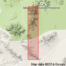
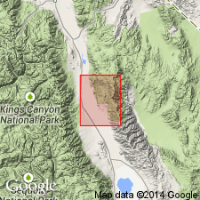
Name Cadiz formation proposed for upper portion of unit described by Hazzard (1933) in Marble and Providence Mountains. Tentatively identified in Inyo Co, CA. Type section measured in west-east direction up west front of high limestone ridge about 2 mi north of National Old Trails HWY where it crosses Marble Mountains about 3 mi north of Cadiz [Cadiz 15' quad, San Bernardino Co, CA]. Consists of buff and gray, oolitic, cross-bedded limestone; platy sandstone; purplish and reddish shales; and platy quartzites. Is about 375 ft thick in Marble Mountains and about 550 ft thick in Providence Mountains. Overlies rocks of Early Cambrian age (known to contain olenellid trilobites). Underlies Bonanza King formation (new). Age is Middle Cambrian based on fauna identified by C.E. Resser. List of fossils collected by J.H. Bradley and J.F. Mason included.
Source: GNU records (USGS DDS-6; Menlo GNULEX).
- Usage in publication:
-
- Cadiz formation*
- Modifications:
-
- Revised
- Areal extent
- AAPG geologic province:
-
- Great Basin province
Summary:
Cadiz formation of Early and Middle Cambrian age is geographically extended into Banded Mountain region of Nevada Test Site and vicinity, Nevada. Generalized geologic section shows Cadiz formation replaces Chisholm shale and Jangle limestone of Johnson and Hibbard (1957). Jangle limestone is reduced to Jangle limestone member in upper part of Cadiz limestone in Nevada Test Site area.
Source: GNU records (USGS DDS-6; Menlo GNULEX).
- Usage in publication:
-
- Cadiz Formation*
- Modifications:
-
- Areal extent
- AAPG geologic province:
-
- Great Basin province
Summary:
Cadiz Formation of Early and Middle Cambrian age not used in this report. The names Latham Shale, Chambless Limestone, and Cadiz Formation replaced with Carrara Formation. Jangle Limestone Member is changed to Jangle Limestone Member of Carrara Formation.
Source: GNU records (USGS DDS-6; Menlo GNULEX).
- Usage in publication:
-
- Cadiz Formation*
- Modifications:
-
- Areal extent
- AAPG geologic province:
-
- Great Basin province
Summary:
Middle Cambrian rocks in the Inyo Mountains previously tentatively assigned to Cadiz Mountain Formation are herein relegated to Monola Formation.
Source: GNU records (USGS DDS-6; Menlo GNULEX).
For more information, please contact Nancy Stamm, Geologic Names Committee Secretary.
Asterisk (*) indicates published by U.S. Geological Survey authors.
"No current usage" (†) implies that a name has been abandoned or has fallen into disuse. Former usage and, if known, replacement name given in parentheses ( ).
Slash (/) indicates name conflicts with nomenclatural guidelines (CSN, 1933; ACSN, 1961, 1970; NACSN, 1983, 2005, 2021). May be explained within brackets ([ ]).