The National Geologic Map Database is migrating to a new infrastructure. We apologize for any service disruptions during this process.
|
|---|


- Usage in publication:
-
- Bryson formation*
- Modifications:
-
- Original reference
- Dominant lithology:
-
- Shale
- Sandstone
- Coal
- AAPG geologic province:
-
- Appalachian basin
Summary:
Pg. 33, 44, 208, and pl. XLA. Bryson formation of Pottsville group. Shales, sandstones, and coals, 0 to 200 feet thick, lying above Red Spring coal (top member of Hignite formation) on higher tops of Log Mountains and possibly on highest points of Black Mountains and Reynolds Mountain. Probably included in time interval of upper part of Kanawha formation. Age is Pennsylvanian.
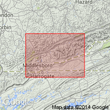
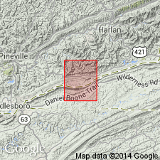
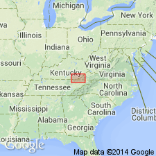
[Named from Bryson Peak, Claiborne Co., northeastern TN. Extends into southeastern KY.]
Source: US geologic names lexicon (USGS Bull. 896, p. 282).
- Usage in publication:
-
- Bryson formation*
- Modifications:
-
- Areal extent
- AAPG geologic province:
-
- Appalachian basin
Summary:
Pg. 111-114, 138. Bryson formation. Highest Pennsylvanian subdivision in Cumberland Gap coal field. Overlies Hignite formation. Partially equivalent to Anderson formation of Tennessee. [Age is Middle Pennsylvanian.]
Source: US geologic names lexicon (USGS Bull. 1200, p. 510).
- Usage in publication:
-
- Bryson formation*
- Modifications:
-
- Revised
- AAPG geologic province:
-
- Appalachian basin
Summary:
Pg. P15. Bryson formation of Ashley and Glenn (1906) transferred to Breathitt group. [Not recognized in Ewing quadrangle.] Is uppermost formation of Breathitt.
Source: Publication; GNC index card files (USGS-Reston).
- Usage in publication:
-
- Bryson Formation*[†]
- Modifications:
-
- [Abandoned]
- AAPG geologic province:
-
- Appalachian basin
Summary:
[See p. A39-A40, A43 (fig. 9). †Bryson Formation of Breathitt Group. Top formation of Breathitt Group, above the †Hignite Formation, along Pine Mountain Fault, in southeasternmost Kentucky, and bordering area of Tennessee and Virginia. Is not formally abandoned herein but its use is clearly discontinued; it is not distinguishable on basis of lithic character and cannot be traced laterally with consistency. As originally defined, it extended from top of Red Spring coal to "higher tops of Log Mountains" and "highest points in Black Mountains." Following the general practice of placing unit boundaries at the base rather than at the top of coal beds, geologists later included the Red Spring in the Bryson. Rocks of the †Bryson are transferred to the Breathitt Formation (reduced in rank to conform with USGS usage elsewhere).
The Bryson was formally abandoned by Rice and others in their glossary (1994, GSA Spec. Paper 294, p. 120, citing McDowell and others, 1985).]
Source: Publication.
For more information, please contact Nancy Stamm, Geologic Names Committee Secretary.
Asterisk (*) indicates published by U.S. Geological Survey authors.
"No current usage" (†) implies that a name has been abandoned or has fallen into disuse. Former usage and, if known, replacement name given in parentheses ( ).
Slash (/) indicates name conflicts with nomenclatural guidelines (CSN, 1933; ACSN, 1961, 1970; NACSN, 1983, 2005, 2021). May be explained within brackets ([ ]).