

- Usage in publication:
-
- Altyn limestone*
- Modifications:
-
- Original reference
- Dominant lithology:
-
- Limestone
- AAPG geologic province:
-
- Northern Rocky Mountain region
Summary:
Pg. 316, 321. Altyn limestone. Upper member consists of 600+/- feet of argillaceous ferruginous limestone, yellow, terra cotta, brown, garnet red; very thin bedded; well exposed in summit of Chief Mountain. Lower member consists of 800+/- feet of massive limestone, grayish blue, heavy bedded, somewhat siliceous, with many flattened concretions, rarely but definitely fossiliferous. Fossils (Eurypterid BELTINA DANAI Walcott) suggest Greyson shale. Underlies Appekunny argillite. Age is pre-Cambrian (Belt).
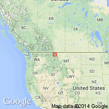
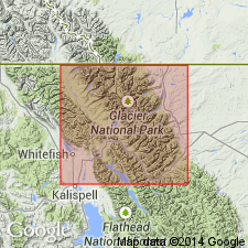
Type locality: in cliffs of Appekunny Mountain, between 6,000 and 7,400 feet above sea, due north of Altyn, in Swift Current Valley, Glacier National Park, Glacier Co., northwestern MT. Entire section exposed only in Waterton Lakes Park, where it is complicated by faults and folds.
Source: US geologic names lexicons (USGS Bull. 896, p. 42; USGS Bull. 1200, p. 68-69).
- Usage in publication:
-
- Altyn formation
- Modifications:
-
- Areal extent
- AAPG geologic province:
-
- Northern Rocky Mountain region
Summary:
Areally extended northward by mapping in BC in the Northern Rocky Mountain region as the second formation from the base (of 8) of the Lewis series. Conformably overlies Waterton formation (named) of Lewis series. Conformably underlies Appekunny formation of Lewis series. Is 3,500 ft thick on Oil Creek on the Atlantic side of the Great Divide where section of gray, sandy, thin-, thick- to massive-bedded limestone measured. Sandy and gritty strata occur in the middle of the formation thus making a three-part division of the formation. Chitinous plates thought to belong to BELTINA genus found in Belt Mountains of MT. Assigned to the Beltian. Geologic maps.
Source: GNU records (USGS DDS-6; Denver GNULEX).

- Usage in publication:
-
- Altyn formation
- Modifications:
-
- Revised
- AAPG geologic province:
-
- Northern Rocky Mountain region
Summary:
Pg. 1881-1884. Altyn formation. Consists of dolomites, limestones, limy argillites, sandstones, and minor mud breccias, which form lower calcareo-magnesian division in Belt sediments in Glacier Park facies. Sediments show considerable variety in color, texture, and bedding; they contain mud cracks, ripple marks, and many beds of flat-pebble and edgewise conglomerates. Upper limit is base of Appekunny formation with which there is some intergradation; lower limit concealed beneath Lewis thrust. Thickness 2,180 to 2,480 feet. Includes (ascending) Waterton (Canada only), Hell Roaring (new), and Carthew (new) members. This definition includes Altyn of Willis (1902) and Daly's Waterton formation because no signiflcant break exists between them. [Age is Precambrian (Belt).]
Source: US geologic names lexicon (USGS Bull. 1200, p. 68-69).
- Usage in publication:
-
- Altyn limestone*
- Modifications:
-
- Areal extent
- AAPG geologic province:
-
- Northern Rocky Mountain region
Summary:
Altyn limestone. Included in Ravalli group. Underlies Appekunny argillite. Age is Precambrian (Belt).
Source: US geologic names lexicon (USGS Bull. 1200, p. 68-69).
- Usage in publication:
-
- Altyn limestone*
- Modifications:
-
- Areal extent
- AAPG geologic province:
-
- Northern Rocky Mountain region
Summary:
Pg. 18-21, pls. 1, 2. Altyn limestone of Ravalli group. Not exposed in Flathead region, and base has nowhere been recognized. Does not appear to be exposed in any other part of Montana. Commonly regarded as part of Ravalli group, a convenient procedure which is herein adopted provisionally. No evidence exists as to stratigraphic relations of the Altyn of Glacier National Park to basal components of Ravalli group in other parts of Montana or to underlying Prichard formation. Fenton's members discussed, but formation not subdivided in present report. Limestone forms Range extending about as far south as Lat. 48 deg. 20 min. N. and northward past Canadian border. Here it immediately overlies Lewis overthrust, and much of it has been cut out by that fault. Also exposed in outlying blocks such as those in Divide and Chief Mountains and on either side of Waterton Lake. Age is Precambrian (Belt).
Source: US geologic names lexicon (USGS Bull. 1200, p. 68-69).

- Usage in publication:
-
- Altyn Limestone*
- Modifications:
-
- Revised
- Age modified
- AAPG geologic province:
-
- Northern Rocky Mountain region
Summary:
Altyn Limestone. Removed from Ravalli Group of Belt Supergroup and designated as pre-Ravalli or lower Belt. Age changed from Ravalli -to- pre-Ravalli (Precambrian Y).
Source: Changes in stratigraphic nomenclature, 1977 (USGS Bull. 1457-A, p. A3).
- Usage in publication:
-
- Altyn Formation*
- Modifications:
-
- Age modified
- Dominant lithology:
-
- Limestone
- Dolomite
- AAPG geologic province:
-
- Northern Rocky Mountain region
Summary:
Altyn Formation of Belt Supergroup. Dark-gray, impure magnesian limestone and dolomite. Fossiliferous (stromatolites). Thickness as much as 2,000 feet. Underlies Greyson Formation (replaces Appekunny in Glacier National Park). May correlate with Newland Limestone. Age is Precambrian Y. (Name change from Altyn Limestone -to- Altyn Formation adopted by the USGS.)
Source: Changes in stratigraphic nomenclature, 1977 (USGS Bull. 1457-A, p. A3); supplemental information from GNU records (USGS DDS-6; Denver GNULEX).
- Usage in publication:
-
- Altyn Formation*
- Modifications:
-
- Mapped
- AAPG geologic province:
-
- Northern Rocky Mountain region
Summary:
Altyn Formation of Belt Supergroup. Recognized on east side of Glacier National Park. Completely exposed in Yellow Mountain area; thickness 238 to 255 m. Lower member, dark-gray to black, thin- to thick-bedded dolomite interbedded with lenticular fine-grained arenite, about 125 m thick; stromatolites common in lower part. Middle member, massive, medium- to thick-bedded dolomite, 58 to 68 m thick. Upper member, interbedded and interlaminated, light-gray to brownish-yellow dolomite, dolarenite, and arenite, thickness 55 to 62 m; stromatolites and styolites common. About 15 miles southward, in Divide Mountain area, middle member is mostly thick beds of brownish-weathering, coarse-grained quartzite. Overlies Waterton Formation and disconformably underlies Appekunny Formation, both of Belt Supergroup. Age is Middle Proterozoic.
Source: Publication.
For more information, please contact Nancy Stamm, Geologic Names Committee Secretary.
Asterisk (*) indicates published by U.S. Geological Survey authors.
"No current usage" (†) implies that a name has been abandoned or has fallen into disuse. Former usage and, if known, replacement name given in parentheses ( ).
Slash (/) indicates name conflicts with nomenclatural guidelines (CSN, 1933; ACSN, 1961, 1970; NACSN, 1983, 2005, 2021). May be explained within brackets ([ ]).