The National Geologic Map Database is migrating to a new infrastructure. We apologize for any service disruptions during this process.
|
|---|


- Usage in publication:
-
- Adams Branch limestone
- Modifications:
-
- Original reference
- Dominant lithology:
-
- Limestone
- AAPG geologic province:
-
- Bend arch
- Llano uplift
Summary:
Pg. 387, 391. Adams Branch limestone in Canyon division. Hard, fossiliferous, unevenly textured, bluish limestone that weathers to rough-surfaced, seamy boulders; base is somewhat arenaceous in places. Thickness 25 to 30 feet. Member of Canyon division [Canyon is 3rd from top of 5 Carboniferous divisions of Cummins, 1891]. Underlies Cedarton bed and overlies Brownwood bed. Fossils include foraminifers, corals, brachiopods, gastropods, and pelecypods. Age is Pennsylvanian.
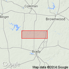
[Type locality: along headwaters of Adams Branch, close to town of Brownwood, Brown Co., Colorado River region, central TX.]
Source: Publication; US geologic names lexicon (USGS Bull. 896, p. 12-13).

- Usage in publication:
-
- Adams Branch limestone member*
- Modifications:
-
- Revised
- AAPG geologic province:
-
- Fort Worth syncline
- Bend arch
- Llano uplift
Summary:
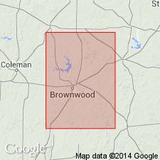
Pg. 59, 84, 96, 101, 102, 114; 1922, Jour. Geol., v. 30, p. 24, 31, 34. Adams Branch limestone is top member of Graford formation (of Canyon group) in both Brazos River and Colorado River valleys, [from McCulloch County to northern Jack County, central northern Texas]. Is 10 to 30 feet thick in southern part of area and 100 locally to north. Is massive escarpment-forming limestone. Forms escarpments 100 to 150 feet high. Underlies Cedarton shale and sandstone and overlies Brownwood member of Graford formation. In Brazos River Valley underlies Seaman Ranch shale. [Age is Pennsylvanian.]
Plummer (1919) called this limestone Graford limestone, top member of Graford formation [Brazos River region]. Since it has been found that this limestone is identical with the Adams Branch limestone of Drake (1893) in the Brownwood district [Colorado River region], and to avoid duplication of a name, the name Adams Branch is here applied (†Grafton limestone member discarded).
[See also entries under Brownwood, Graford formation, and Graford limestone member.]
Source: US geologic names lexicon (USGS Bull. 896, p. 12-13, 278, 846, 847); supplemental information from GNU records (USGS DDS-6; Denver GNULEX).
- Usage in publication:
-
- Adams Branch limestone member
- Modifications:
-
- Revised
- AAPG geologic province:
-
- Fort Worth syncline
- Bend arch
Sellards, E.H., 1931, [Discussion in News Letter, September, 1931]: University of Texas-Austin, Bureau of Economic Geology
Summary:
Stated that Adams Branch limestone is approximately same as Palo Pinto limestone, and treated it as a member of Palo Pinto formation. Age is Pennsylvanian.
Source: US geologic names lexicon (USGS Bull. 896, p. 12-13).

- Usage in publication:
-
- Adams Branch limestone member*
- Modifications:
-
- Revised
- AAPG geologic province:
-
- Fort Worth syncline
- Bend arch
- Llano uplift
Summary:
Pg. 111. Adams Branch limestone member of Graford formation of Canyon group. Extended top of Graford formation up to top of Merriman limestone (Clear Creek limestone of Drake), which had been mistaken for Adams Branch limestone in some previous reports, but which is much younger limestone. Age is Pennsylvanian. (See 1933 entry under Graford formation.) This definition of Graford formation was adopted by the USGS in 1935.
Source: US geologic names lexicon (USGS Bull. 896, p. 12-13).
- Usage in publication:
-
- Adams Branch limestone member
- Modifications:
-
- Overview
- AAPG geologic province:
-
- Bend arch
- Llano uplift
Summary:
Drew top of Graford formation of Colorado River region at top of Adams Branch limestone member. Age is Pennsylvanian.
Source: US geologic names lexicon (USGS Bull. 896, p. 12-13).

- Usage in publication:
-
- Adams Branch limestone member*
- Modifications:
-
- Overview
- AAPG geologic province:
-
- Fort Worth syncline
- Bend arch
- Llano uplift
Summary:
Adams Branch limestone member of Graford formation. In 1935 the USGS adopted (for report by Wallace Lee and C.O. Nickell, soon to be published by the Texas Geol. Survey) a definition of Graford formation that included in it a great thickness of rocks younger than true Adams Branch limestone of Colorado River region. Age is Pennsylvanian. (See under Graford formation.)
[Wallace Lee, C.O. Nickell, J.S. Williams, and L.G. Henbest, 1938, Stratigraphic and paleontologic studies of the Pennsylvanian and Permian rocks in north-central Texas, Univ. Texas Bull., no. 3801.]
Source: US geologic names lexicon (USGS Bull. 896, p. 12-13).

- Usage in publication:
-
- Adams Branch formation
- Modifications:
-
- Revised
- AAPG geologic province:
-
- Bend arch
Summary:
Pg. 66 (fig. 1), 88. Adams Branch formation of Graford group. Rank raised to formation in Graford group (redefined). Expanded below to include shale and sandstone section about 50 feet thick above Wiles limestone member of Palo Pinto formation. Age is Late Pennsylvanian (Canyon); Canyon thought to be approximately equivalent to Missourian of Kansas.
Source: US geologic names lexicon (USGS Bull. 1200, p. 18).
- Usage in publication:
-
- Adams Branch limestone member*
- Modifications:
-
- Areal extent
- AAPG geologic province:
-
- Bend arch
Summary:
Pg. 64-65. Adams Branch limestone, middle member of Graford formation of Canyon group. Commonly light-gray wavy-bedded slabby limestone. A few miles northeast of Brownwood, member grades laterally into shale, calcareous sandstone, and, in some places, a coquina of brachiopod, mollusk, and crinoid fragments. Thickness about 15 feet, just west of Brownwood; thickens downdip to about 40 feet in wells; 50 to 60 feet in McCulloch County, south of Colorado River. Overlies Brownwood shale member; underlies Cedarton shale member. [Age is Late Pennsylvanian (Missourian).]
Source: US geologic names lexicon (USGS Bull. 1200, p. 18).
- Usage in publication:
-
- Adams Branch limestone member
- Modifications:
-
- Revised
- AAPG geologic province:
-
- Bend arch
Summary:
Pg. 7 (fig. 2), 14. Adams Branch limestone member of Brookesmith formation (new) of Canyon group. The Graford formation of Eargle (1960, USGS Prof. Paper 315-D) is restricted from the Colorado River Valley area, north-central Texas. The Adams Branch and Cedarton members are reallocated to newly established Brookesmith formation (from village of Brookesmith, Brown County, Texas). The Brownwood shale member is raised to formation rank and includes Rochelle conglomerate member at base.
Source: Publication.
- Usage in publication:
-
- Adams Branch Limestone Member*
- Modifications:
-
- Biostratigraphic dating
- AAPG geologic province:
-
- Bend arch
Summary:
Pg. C1, C4, C11; see also USGS Prof. Paper 550-B, p. B47-B50, 1966. Adams Branch Limestone Member of Graford Formation of Canyon Group. Measured section along Adams Branch in cuts of Gulf, Colorado and Santa Fe RR, 3 miles from Brownwood, Brown County, Texas. Thickness 36 feet. Age is Late Pennsylvanian (early Missourian of Midcontinent terminology); lies at base of TRITICITES faunal zone.
Fusulinids: TRITICITES MUSCERDA Myers, n. sp. (USGS fossil loc. f10018, f10028, f10099, f10100, f10110, f10115, f10116 collected from near top of member); OKETAELLA EARGLEI Myers, 1966 (USGS fossil loc. f10109 collected from upper part of member); KANSANELLA VOLUMINOSA Myers, n. sp. (USGS fossil loc. f10001, f10013, f10112, f10113, f10114 collected from basal few feet of member).
Source: Publication; GNC index card files (USGS-Reston).
For more information, please contact Nancy Stamm, Geologic Names Committee Secretary.
Asterisk (*) indicates published by U.S. Geological Survey authors.
"No current usage" (†) implies that a name has been abandoned or has fallen into disuse. Former usage and, if known, replacement name given in parentheses ( ).
Slash (/) indicates name conflicts with nomenclatural guidelines (CSN, 1933; ACSN, 1961, 1970; NACSN, 1983, 2005, 2021). May be explained within brackets ([ ]).