

- Usage in publication:
-
- Redonda member*
- Modifications:
-
- Named
- Dominant lithology:
-
- Sandstone
- Shale
- Limestone
- AAPG geologic province:
-
- Palo Duro basin
Summary:
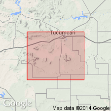
Named as the upper member of Chinle formation. Named presumably for Redonda Mesa in T9N, Rs30 and 31E, Quay Co, NM in the Palo Duro basin. No type locality designated. Conformably overlies unnamed lower member of Chinle. Unconformably underlies Wingate? sandstone. Consists of variegated and red shale, argillaceous limestone, and red or buff sandstone that range in thickness from 25 to 425 ft thick. Basal beds are limestone, sandy limestone, or sandy or shaly limestone. Is about 190 to 425 ft thick at Redonda Mesa. Cross sections. Geologic map; extends into San Miguel Co which is also in the Palo Duro basin; mapped along the edge of the Llano Estacado, Louisiana Mesa, Mesa Rica, across map west and central parts, Tucumcari Mountain and Mesa Redonda. Assigned a Triassic age.
Source: GNU records (USGS DDS-6; Denver GNULEX).
- Usage in publication:
-
- Redonda formation*
- Modifications:
-
- Revised
- AAPG geologic province:
-
- Palo Duro basin
- Sierra Grande uplift
Summary:
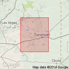
Raised in stratigraphic rank from Redonda member of Chinle formation to Redonda formation, a unit that overlies the Chinle and underlies the Entrada sandstone in Harding Co, (Sierra Grande uplift) and San Miguel, Guadalupe, and Ouray Cos (Palo Duro basin). Rocks now assigned to Entrada were previously assigned to Wingate sandstone, a term no longer used in northeast NM. Consists of alternating clayey siltstone and fine-grained sandstone in regular beds of the same thickness for considerable distances. Has tracks of bipedal dinosaurs and a phytosaur skull indicating latest Triassic age. Is tentatively correlated with Wingate sandstone of the Colorado Plateau.
Source: GNU records (USGS DDS-6; Denver GNULEX).
- Usage in publication:
-
- Redonda Formation
- Modifications:
-
- Contact revised
- AAPG geologic province:
-
- Palo Duro basin
Summary:
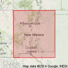
Lower contact revised in that Redonda conformably overlies the newly named Bull Canyon Formation in east-central NM in the Palo Duro basin. Was the uppermost of 4 members of Chinle Formation in this area in previous reports. Stratigraphic rank of Redonda revised from upper member of Chinle Formation (Chinle is a name not used in east-central NM) to Redonda Formation. May be as much as 92 m thick. Is a laterally continuous unit of interbedded red-brown, fine-grained sandstone and mudstone. Deposited in an extensive (5,000 sq km) lake. Fossil plants scarce, but invertebrate fossils abundant. Has lacustrine-beach and fluvial fossil assemblages. Vertebrate fossils also. Nomenclature chart. Is the youngest Late Triassic unit in area.
Source: GNU records (USGS DDS-6; Denver GNULEX).
- Usage in publication:
-
- Redonda Formation
- Modifications:
-
- Areal extent
- AAPG geologic province:
-
- Las Vegas-Raton basin
- Palo Duro basin
Summary:
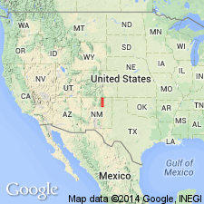
Can be recognized as far north as Naranjos, Mora Co, NM in the Las Vegas-Raton basin. Between Naranjos and south to San Sebastian in San Miguel Co, NM in the Palo Duro basin, the formation ranges between 60 and 65 m thick. Bears a strong resemblance to the Redonda of the Tucumcari area. In both areas, it overlies Bull Canyon Formation and underlies Entrada Sandstone. Identified in measured sections at San Sebastian Canyon, San Miguel Co, NM, Palo Duro basin and at Naranjos, Mora Co. Cross sections. Correlation chart. Has vertebrate fauna. Of middle? Norian, Late Triassic age.
Source: GNU records (USGS DDS-6; Denver GNULEX).
For more information, please contact Nancy Stamm, Geologic Names Committee Secretary.
Asterisk (*) indicates published by U.S. Geological Survey authors.
"No current usage" (†) implies that a name has been abandoned or has fallen into disuse. Former usage and, if known, replacement name given in parentheses ( ).
Slash (/) indicates name conflicts with nomenclatural guidelines (CSN, 1933; ACSN, 1961, 1970; NACSN, 1983, 2005, 2021). May be explained within brackets ([ ]).