

- Usage in publication:
-
- Conant Creek Tuff*
- Modifications:
-
- Named
- Reference
- Geochronologic dating
- Dominant lithology:
-
- Tuff
- AAPG geologic province:
-
- Yellowstone province
Summary:
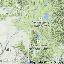
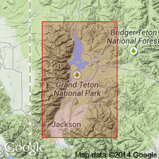
Named (formerly an unnamed tuff) for Conant Creek near its type section measured on north side of South Boone Creek where a steep-sided tributary enters the main creek in NE1/4 SW1/4 sec 5, T47N, R117W, Grassy Lake Reservoir quad, Teton Co, WY in the Yellowstone province. Is a 407 ft thick, pale-purplish-pink to purplish-gray, grayish-brown, nonwelded, moderately to densely welded ash-flow tuff with phenocrysts (large to small) of quartz, sanidine, and plagioclase at type. Unconformably underlain by Hominy Peak Formation; unconformably overlain by Huckleberry Ridge Tuff at type. Is 27 ft thick at reference section measured on south face of Hill 8373, SE1/4 SW1/4 sec 16, T47N, R117W, Grassy Lake Reservoir quad, Teton Co. Is an ash-flow tuff that varies from grayish brown, pinkish gray, black, orange-pink, nonwelded, partially to densely welded. Was faulted and tilted slightly westward. Erosion created a moderate to rough topography on it before Huckleberry Ridge emplaced. Pliocene age determination from obsidian from base of ash-flow tuff dated by K-Ar method as 5.78 +/-0.08 m.y., and by fission-track method as 4.2 +/-0.7 m.y. Is exposed on both sides of Teton Range, and in nearby WY and ID (Snake River basin). Has reverse paleomagnetic polarity.
Source: GNU records (USGS DDS-6; Denver GNULEX).
- Usage in publication:
-
- Conant Creek Tuff*
- Modifications:
-
- Contact revised
- AAPG geologic province:
-
- Yellowstone province
Summary:
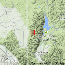
Pg. 3, 7, 8 (fig. 4). Conant Creek Tuff. Ryholitic ash-flow tuff. Exposed at north end of Teton Range, Wyoming. Unconformably overlies Hominy Peak Formation (new) of Absaroka Volcanic Supergroup. Age is Pliocene. Report includes geologic map, measured section.
Source: Publication.
- Usage in publication:
-
- Conant Creek Tuff*
- Modifications:
-
- Age modified
- AAPG geologic province:
-
- Yellowstone province
- Idaho Mountains province
Summary:
Age of the Conant Creek Tuff is modified from Pliocene to Miocene based on stratigraphic relationships.
Source: GNU records (USGS DDS-6; Menlo GNULEX).

- Usage in publication:
-
- Conant Creek Tuff*
- Modifications:
-
- Geochronologic dating
- AAPG geologic province:
-
- Yellowstone province
Summary:
Has a K-Ar age of 5.89 Ma (Pliocene) and a reversed magnetic polarity.
Source: GNU records (USGS DDS-6; Denver GNULEX).
- Usage in publication:
-
- Conant Creek Tuff*
- Modifications:
-
- Age modified
- Areal extent
- Geochronologic dating
- AAPG geologic province:
-
- Yellowstone province
Summary:
Rocks formerly considered part of Bivouac Formation (abandoned) on Signal Mountain (T45N, R114W), Teton Co, WY, Yellowstone province are recognized as belonging to Conant Creek Tuff where 200 to 250 ft remain. Is present in subsurface to north. Measured sections. Overlaps rocks that range from Eocene to Miocene. Rocks formerly assigned to Bivouac are divisible into (ascending order): unnamed gravel (late Miocene) and Conant Creek Tuff of early Pliocene age, deposits of glaciation 1 of Pliocene age, and Huckleberry Ridge Tuff of latest Pliocene age. Age changed from Miocene to early Pliocene based on author's reliance on a date of 4.2 +/-0.7 Ma by F-T method rather than a date of 5.78 +/-0.8 Ma by the K-Ar method at type.
Source: GNU records (USGS DDS-6; Denver GNULEX).
- Usage in publication:
-
- Conant Creek Tuff*
- Modifications:
-
- Age modified
- AAPG geologic province:
-
- Yellowstone province
Summary:
Age changed from Miocene to Pliocene on basis of a 4.2 +/-0.7 Ma (fission-track) age obtained from obsidian from near base in Park area, WY, Yellowstone province. This age is in accord with K-Ar ages obtained from the tuffs in the Kilgore area, eastern ID, of 4.1 +/-0.1 to 4.8 +/-0.3 Ma. The tuffs in ID are of the same composition and lithology as those in the Park.
Source: GNU records (USGS DDS-6; Denver GNULEX).

- Usage in publication:
-
- Conant Creek Tuff*
- Modifications:
-
- Age modified
- AAPG geologic province:
-
- Yellowstone province
Summary:
[Not synopsized to date.]
Source: GNU records (USGS DDS-6; Denver GNULEX).
For more information, please contact Nancy Stamm, Geologic Names Committee Secretary.
Asterisk (*) indicates published by U.S. Geological Survey authors.
"No current usage" (†) implies that a name has been abandoned or has fallen into disuse. Former usage and, if known, replacement name given in parentheses ( ).
Slash (/) indicates name conflicts with nomenclatural guidelines (CSN, 1933; ACSN, 1961, 1970; NACSN, 1983, 2005, 2021). May be explained within brackets ([ ]).