The National Geologic Map Database is migrating to a new infrastructure. We apologize for any service disruptions during this process.
|
|---|


- Usage in publication:
-
- Woodhurst limestone [member]*
- Modifications:
-
- Original reference
- Dominant lithology:
-
- Limestone
- AAPG geologic province:
-
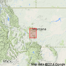
- Sweetgrass arch
Summary:
Woodhurst limestone member of Madison limestone. Well-bedded light-colored limestones separated by very thin argillaceous layers, the limestones often carrying much dark chert. The Woodhurst limestone is well jointed and often forms masonry-like exposures of cliffs with balcony ledges and retreating benches. On weathering breaks into small angular fragments. Underlies Castle limestone member and overlies Paine shale, which consists of thin-bedded shaly limestones, commonly of gray color.
[Origin of name not stated, but Madison limestone is mapped over broad area at and surrounding Woodhurst Mountain, northeastern corner of this quadrangle.]
Source: US geologic names lexicon (USGS Bull. 896, p. 2366-2367).
- Usage in publication:
-
- Woodhurst member
- Modifications:
-
- Revised
- AAPG geologic province:
-
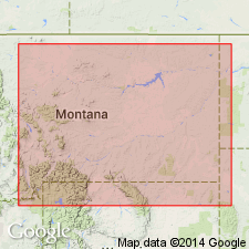
- Central Montana uplift
- Montana folded belt
- Yellowstone province
- Sweetgrass arch
- Williston basin
Summary:
Pg. 315, 317, 319, 320, 321-322, 324. Woodhurst member of Lodgepole limestone. Reallocated to member status in Lodgepole limestone. Described from sections in the Little Belt Mountains, Big Snowy Mountains, Little Rocky Mountains, Bridger Range, and [town of] Logan, Montana (Sweetgrass arch, Central Montana uplift, Williston basin, Montana folded belt province, and Yellowstone province). Thickness 240 to 570 feet. Conformably overlies Paine member of Lodgepole; conformably underlies Mission Canyon formation. Describes characteristics of insoluble residues. Age is Mississippian.
Source: US geologic names lexicon (USGS Bull. 1200, p. 4294-4295); GNU records (USGS DDS-6; Denver GNULEX).
- Usage in publication:
-
- Woodhurst Member*
- Modifications:
-
- Principal reference
- Biostratigraphic dating
- Dominant lithology:
-
- Limestone
- Chert
- AAPG geologic province:
-
- Sweetgrass arch
- Williston basin
- Montana folded belt
Summary:
Woodhurst Member of Lodgepole Limestone of Madison Group. Consists of interbedded fine-, medium-, and coarse-grained argillaceous and cherty limestone. Thickness 526.0 feet. Conformably underlies Mission Canyon Limestone; conformably overlies Paine Member of Lodgepole. Age is Early Mississippian (Osagean) based on corals, brachiopods, and foraminifers.
Type section established above the road along the Dry Fork of Belt Creek at the intersection of Currie Coulee, from SE/4 sec. 35, T. 16 N., R. 7 E., to NW/4 SE/4 sec. 36, T. 16 N., R. 7 E., Cascade Co., MT.
Detailed descriptions of other sections: (1) at Logan, in SE/4 SW/4 sec. 25, T. 2 N., R. 2 E., Gallatin Co., MT; and (2) in the Little Chief Canyon, a tributary of Lodgepole Creek, in NW/4 sec. 30, and SE/4 sec. 19, T. 26 N., R. 25 E., Blaine Co., MT.
Source: Modified from GNU records (USGS DDS-6; Denver GNULEX).
- Usage in publication:
-
- Woodhurst Member*
- Modifications:
-
- Revised
- AAPG geologic province:
-
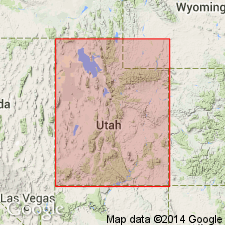
- Great Basin province
- Wasatch uplift
Summary:
Woodhurst Member, upper member of Lodgepole Limestone. Upper surface is a hardground. Underlies Delle Phosphatic Member (new) of: Woodman Formation in the South Lakeside Mountains, Tooele County, Utah; Little Flat Formation in the Chesterfield Range, Bannock County, Idaho; Brazer Dolomite in Brazer Canyon, Crawford Mountains, Rich County, Utah. Age is Early Mississippian (Kinderhookian and Osagean). Report includes correlation chart.
Source: Modified from GNU records (USGS DDS-6; Denver GNULEX).
For more information, please contact Nancy Stamm, Geologic Names Committee Secretary.
Asterisk (*) indicates published by U.S. Geological Survey authors.
"No current usage" (†) implies that a name has been abandoned or has fallen into disuse. Former usage and, if known, replacement name given in parentheses ( ).
Slash (/) indicates name conflicts with nomenclatural guidelines (CSN, 1933; ACSN, 1961, 1970; NACSN, 1983, 2005, 2021). May be explained within brackets ([ ]).