

- Usage in publication:
-
- West Falls Formation*
- Modifications:
-
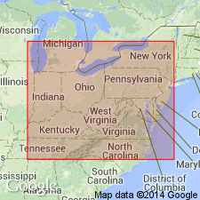
- Areal extent
- AAPG geologic province:
-
- Appalachian basin
Summary:
West Falls Formation (as its Rhinestreet Shale Member) extended from NY, PA, and OH into western WV, eastern KY, western VA, and eastern TN.
Source: GNU records (USGS DDS-6; Reston GNULEX).

- Usage in publication:
-
- West Falls Formation*
- Modifications:
-
- Overview
- AAPG geologic province:
-
- Appalachian basin
Summary:
In outcrop in western NY, the West Falls consists of a lower black shale, the Rhinestreet Shale Member and an upper gray shale and mudrock with abundant limestone nodules, the Angola Shale Member. Both members interfinger to the east into an eastward-thickening sequence of siltier and sandier rocks. The Angola is not recognized east of the Genesee River, although the Rhinestreet is present near Elmira in central Chemung Co., NY. The Rhinestreet is also identified in the subsurface from western NY to eastern TN. In outcrop in TN, the Rhinestreet is a 6-ft bed in the lower part of the Dowelltown Member of the Chattanooga Shale. The Belpre Ash Bed is present in the lower part of the Rhinestreet in the western part of the Appalachian basin. In the subsurface, the Angola is recognized from western NY to eastern TN and westward into OH and eastern KY. Extends further west than the Rhinestreet, underlying the Pipe Creek Shale Member of the Java Formation.
Source: GNU records (USGS DDS-6; Reston GNULEX).
For more information, please contact Nancy Stamm, Geologic Names Committee Secretary.
Asterisk (*) indicates published by U.S. Geological Survey authors.
"No current usage" (†) implies that a name has been abandoned or has fallen into disuse. Former usage and, if known, replacement name given in parentheses ( ).
Slash (/) indicates name conflicts with nomenclatural guidelines (CSN, 1933; ACSN, 1961, 1970; NACSN, 1983, 2005, 2021). May be explained within brackets ([ ]).