

- Usage in publication:
-
- Wabash formation
- Modifications:
-
- Original reference
- Dominant lithology:
-
- Sandstone
- Shale
- Limestone
- Coal
- AAPG geologic province:
-
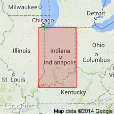
- Illinois basin
Summary:
Wabash formation. Lower half heavy sandstones, with thin shales, limestones, and coal beds; upper half alternating sandstones and shales. Thickness 180 feet. Basal bed is Parker coal. Underlain by Inglefield sandstone [supposed = Merom sandstone] and overlain by Tertiary river deposits. Age is Pennsylvanian.
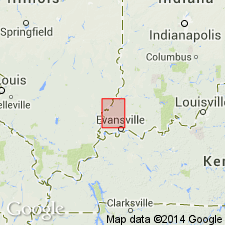
Named from exposures in bluff of Wabash River in Patoka quadrangle, southwestern IN.
Source: US geologic names lexicon (USGS Bull. 896, p. 2258).
- Usage in publication:
-
- Wabash formation
- Modifications:
-
- [Areal extent]
- AAPG geologic province:
-
- Illinois basin
Summary:
Pg. 526. Wabash formation of Fuller and Clapp is recognized provisionally, pending final determination of its relations to Merom sandstone, which in this report is treated as terminal member of Pennsylvanian in Indiana.
Source: US geologic names lexicon (USGS Bull. 896, p. 2258).

- Usage in publication:
-
- Wabash formation
- Modifications:
-
- Revised
- AAPG geologic province:
-
- Illinois basin
Summary:
Chart 6 (column 25). Wabash formation. Shown on Pennsylvanian correlation chart as comprising (ascending) Parker limestone, Buffkin limestone, Graysville limestone, and Livingston limestone. Occurs above Inglefield sandstone and below Merom sandstone. Age is Pennsylvanian. Present in southwestern Indiana.
Source: US geologic names lexicon (USGS Bull. 1200, p. 4094).
- Usage in publication:
-
- Wabash Formation†
- Modifications:
-
- Abandoned
- AAPG geologic province:
-
- Illinois basin
Summary:
Pg. 34-47. Term Wabash Formation proposed by Fuller and Clapp (1904, USGS Geol. Atlas of the US, Patoka folio, no. 105) for rocks of Pennsylvanian age [in southwestern Indiana] has had little usage and is herein considered abandoned.
Authors applied name to Silurian age rocks in northern Indiana; see entry under Silurian Wabash.
Source: US geologic names lexicon (USGS Bull. 1350, p. 800-801).
For more information, please contact Nancy Stamm, Geologic Names Committee Secretary.
Asterisk (*) indicates published by U.S. Geological Survey authors.
"No current usage" (†) implies that a name has been abandoned or has fallen into disuse. Former usage and, if known, replacement name given in parentheses ( ).
Slash (/) indicates name conflicts with nomenclatural guidelines (CSN, 1933; ACSN, 1961, 1970; NACSN, 1983, 2005, 2021). May be explained within brackets ([ ]).