


- Usage in publication:
-
- Thrifty formation
- Modifications:
-
- Named
- Dominant lithology:
-
- Shale
- Sandstone
- Limestone
- Coal
- AAPG geologic province:
-
- Bend arch
- Llano uplift
- Fort Worth syncline
Summary:
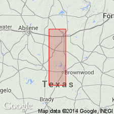
Named for Thrifty, Brown Co, TX on Bend arch. No type locality designated. Is second from base of six formations of Cisco group (revised). Disconformably overlies newly named Graham formation of Cisco; underlies newly named Harpersville formation of Cisco. In Brazos River Valley Thrifty is divided into following members (ascending): Avis sandstone; unnamed limestone, unnamed shale and sandstone; Ivan limestone; unnamed shale and sandstone; Blach Ranch limestone; unnamed shale; and Breckenridge limestone. Divided in the Colorado River Valley into following members (ascending): unnamed shale, sandstone, and limestone; Speck Mountain limestone; unnamed shale, sandstone, and limestone; and Breckenridge limestone. Mapped from Jermyn in Jack Co (Fort Worth syncline) to west of Graham in Young Co (Bend arch), to southeast of Breckenridge; thence southwest of Wayland and Gunsight to Eastland Co, where it passes beneath Cretaceous beds. Small outliers occur in the midst of the Cretaceous sands. Reappears to south in Brown Co, and is traced southward to Llano Mountain area southwest of Brady (Llano uplift). Consists of alternating, more or less lenticular beds of shale, sandstone, and limestone. Limestones are thin but mostly persistent over long distances; sandstones are locally conglomeratic. In Colorado River area there are local coal beds [which Drake called the "Chaffin Bed"]. Stratigraphic chart, sections, fossil lists. Pennsylvanian.
Source: GNU records (USGS DDS-6; Denver GNULEX).
- Usage in publication:
-
- Thrifty formation*
- Modifications:
-
- Biostratigraphic dating
- AAPG geologic province:
-
- Bend arch
Summary:
Thrifty formation of Cisco group. Includes (descending) Chaffin limestone member, Breckenridge limestone member, and Speck Mountain limestone member. Typical fusulinid faunas of members are illustrated. Age is Late Pennsylvanian.
Recognized in Coleman, Brown, Eastland, and Stephens Cos., central TX.
Source: Publication; US geologic names lexicon (USGS Bull. 1200, p. 3877-3878).

- Usage in publication:
-
- Thrifty Formation
- Modifications:
-
- Areal extent
- AAPG geologic province:
-
- Bend arch
- Fort Worth syncline
Summary:
Mapped (undivided) with underlying Graham Formation as basal formation of Cisco Group. Mapped in southeast part of sheet in Young Co, TX on the Bend arch and in adjoining Jack Co, TX on the Fort Worth syncline. Several limestone beds--Gonzales Creek, Gonzales, and Jacksboro--are mapped with Thrifty and Graham, [but they are unranked and not clearly assigned to either formation]. Thrifty and Graham (undivided) is equivalent to lower part of Markley Formation of Bowie Group (both first used) of the eastern part of the mapped area. Underlies Harpersville Formation (revised) of Cisco Group in the western part of the area. Deposits of Markley that are equivalent to Thrifty and Graham (undivided) are exposed on adjacent Sherman sheet. Thickness of Thrifty and Graham (undivided) is 150-500 ft; thins noticeably northeastward. Of Virgil (Late Pennsylvanian) age. Geologic map.
Source: GNU records (USGS DDS-6; Denver GNULEX).

- Usage in publication:
-
- Thrifty Formation
- Modifications:
-
- Areal extent
- AAPG geologic province:
-
- Fort Worth syncline
Summary:
Pamphlet [p. 10-11]. Thrifty and Graham Formations, [undifferentiated], of Cisco Group. Mudstone, shale, limestone, and sandstone; mostly mudstone and shale in units 5 to 30 feet thick, light-gray, weather to greenish-gray and tan, poorly exposed; laminated and cross-laminated calcareous sandstone in platy thin beds throughout; fine-grained sheet sandstone 2 to 4 feet thick locally in interval between Lower Gunsight and Bunger Limestones [unranked], calcareous, in part conglomeratic with limestone clasts, laminated, locally bioturbated. Limestone, ls1, [probably = ls unit of Markley Formation of Bowie Group], locally comprises two limestone units separated by gray shale 4 feet thick; upper limestone, gray to tan, fine-grained, sandy, argillaceous, sparsely fossiliferous, single thin bed 4 to 8 inches thick, becomes sandier westward; lower limestone present in eastern outcrops, gray, medium- to coarse-grained, bioclastic, thin and irregular beds; thickness 1 to 3 feet. The contact between the Thrifty and Graham Formations, [undifferentiated] and the Markley is marked by a stratigraphic cutoff that coincides with a local overlap of Cretaceous rocks (Antlers Sand) in northeastern Jack and southwestern Montague Counties. [Middle and upper parts of Thrifty and Graham Formations, undifferentiated = lower part of Markley (below ss6) exposed along western edge of map sheet in Lake Amon G. Carter area.] Thrifty and Graham Formations, [undifferentiated] lies above Colony Creek Shale of Canyon Group. Thickness less than 200 feet. Age is Late Pennsylvanian (Virgilian).
[Mapped in Jack and Wise Cos., central northern TX; western edge of map sheet. Rocks previously (1967 ed. of map) included in "Permian rocks above Graham Formation" and "Graham and Caddo Creek Formations, undivided." See also Hentz, 1988, and adjacent Wichita Falls-Lawton sheet, Texas Geol. Atlas, 1987.]
Source: Publication.
For more information, please contact Nancy Stamm, Geologic Names Committee Secretary.
Asterisk (*) indicates published by U.S. Geological Survey authors.
"No current usage" (†) implies that a name has been abandoned or has fallen into disuse. Former usage and, if known, replacement name given in parentheses ( ).
Slash (/) indicates name conflicts with nomenclatural guidelines (CSN, 1933; ACSN, 1961, 1970; NACSN, 1983, 2005, 2021). May be explained within brackets ([ ]).