The National Geologic Map Database is migrating to a new infrastructure. We apologize for any service disruptions during this process.
|
|---|


- Usage in publication:
-
- Teutonic limestone*
- Modifications:
-
- Named
- Dominant lithology:
-
- Limestone
- AAPG geologic province:
-
- Great Basin province
Summary:
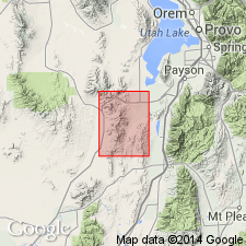
Named for Teutonic Ridge, T10S, R3W, Eureka 7.5' quad, Juab Co, UT, Great Basin province. Formerly included in Mammoth or Eureka limestone. No type locality designated. Is well exposed from town of Robinson, on east side Quartzite Ridge where section 566 ft thick measured, and on west side of Teutonic Ridge. Described on Teutonic Ridge (measured section) as a dark blue-gray limestone with many veinlets that is 566 ft thick. Some beds thin-bedded, ribboned or mottled with bands or small blotches of yellowish-brown argillaceous "material." Upper limestone is finely banded and cross-bedded in upper part. Second section 564+ ft thick measured on spur southwest of Dagmar shaft. Stratigraphically younger than Ophir Formation (new) and older than Dagmar limestone (new). No fossils found, but lies between known Middle Cambrian beds, and therefore assigned to the Middle Cambrian based on stratigraphic position. Geologic map. Cross sections.
Source: GNU records (USGS DDS-6; Denver GNULEX).

- Usage in publication:
-
- Teutonic limestone*
- Modifications:
-
- Overview
- AAPG geologic province:
-
- Great Basin province
- Wasatch uplift
Summary:
Exposed in North, main, and East Tintic districts, Great Basin province and Wasatch uplift. Has been penetrated in many mines in the East Tintic district. A section 400 ft thick measured near center sec 24, T10S, R3W, Juab Co, where the formation overlies Ophir formation and underlies Dagmar dolomite. Middle Cambrian fossils identified. Geologic map. Correlation diagrams.
Source: GNU records (USGS DDS-6; Denver GNULEX).
For more information, please contact Nancy Stamm, Geologic Names Committee Secretary.
Asterisk (*) indicates published by U.S. Geological Survey authors.
"No current usage" (†) implies that a name has been abandoned or has fallen into disuse. Former usage and, if known, replacement name given in parentheses ( ).
Slash (/) indicates name conflicts with nomenclatural guidelines (CSN, 1933; ACSN, 1961, 1970; NACSN, 1983, 2005, 2021). May be explained within brackets ([ ]).