The National Geologic Map Database is migrating to a new infrastructure. We apologize for any service disruptions during this process.
|
|---|


- Usage in publication:
-
- Tenmile granite*
- Modifications:
-
- Original reference
- Dominant lithology:
-
- Granite
- AAPG geologic province:
-
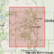
- Southern Rocky Mountain region
Summary:
Tenmile granite. Pink and gray biotite granite. Intrudes Archean schists, but does not intrude the Algonkian rocks. [Age is pre-Cambrian.]
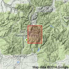
Named from Tenmile Creek, which enters Animas River southeast of Snowdon Peak, Needle Mountains 15-min quadrangle, [San Juan Co.], southwestern CO.
[GNC remark (ca. 1936, US geologic names lexicon, USGS Bull. 896, p. 2128-2129): Was assigned to Algonkian by E.S. Larsen in USGS Bull. 843, 1933. The terms "Algonkian system" and "Archean system" were discarded by the USGS in 1934. For 1935 Colorado geol. map this formation was included in Front Range granite group and assigned to pre-Cambrian.]
Source: US geologic names lexicon (USGS Bull. 896, p. 2128-2129).
- Usage in publication:
-
- Tenmile Granite*
- Modifications:
-
- Overview
- Geochronologic dating
- AAPG geologic province:
-
- Southern Rocky Mountain region
Summary:
Forms an oval-shaped stock in Needle Mountains whose major axis trends east-northeast and is about 4.2 mi long, and whose minor axis trends west-southwest and is about 2.2 mi long. Intrudes Irving Formation. Mapped on sketch map along Animas River valley in San Juan Co, CO in the Southern Rocky Mountain region. Shown in map explanation as equivalent to Bakers Bridge Granite, as younger than Twilight Gneiss and as older than Uncompahgre Formation. Is typically pink to light-gray to brownish-gray, medium- to coarse-grained, homogeneous granite. Has radiometric age of 1,720 +/-20 m.y. (U-Pb on zircon) and 1,724 +/-55 m.y. (Rb-Sr whole-rock).
Source: GNU records (USGS DDS-6; Denver GNULEX).
- Usage in publication:
-
- Tenmile Granite*
- Modifications:
-
- Overview
- AAPG geologic province:
-
- Southern Rocky Mountain region
Summary:
In moderately large stock in Needle Mountains. Includes also small stocks and dikes formerly assigned to Whitehead Granite (abandoned). Listed with granitic rocks of circa 1,700 m.y. (Precambrian X) age group.
Source: GNU records (USGS DDS-6; Denver GNULEX).
- Usage in publication:
-
- Tenmile Granite
- Modifications:
-
- Revised
- AAPG geologic province:
-
- Southern Rocky Mountain region
Summary:
Contact relationship and depositional sequence of Middle Proterozoic rocks reinterpreted. Uncompahgre Formation thought to have been deposited before 1,540 m.y. and deformed before 1,430 m.y. and in thrust contact with Tenmile. New relationship shown on Figure 1.
Source: GNU records (USGS DDS-6; Denver GNULEX).
- Usage in publication:
-
- Tenmile Granite*
- Modifications:
-
- Overview
- AAPG geologic province:
-
- Southern Rocky Mountain region
Summary:
Is one of nine formal lithodemic units assigned to the Early Proterozoic Routt Plutonic Suite (new name). Is present in a single stock in the Needle Mountains bisected by the Animas River about 12 km (8 mi) south of Silverton and in small bodies farther north. These localities are in CO in the Southern Rocky Mountain region. Some of the rocks in these small bodies were assigned to Whitehead Granite by Cross and Howe (1905). Is principally a pink to light-gray, medium- to coarse-grained granite. Has been dated as 1,695 +/-20 m.y. (U-Pb method), and as 1,690 +/-55 m.y. (Rb-Sr method).
Source: GNU records (USGS DDS-6; Denver GNULEX).
For more information, please contact Nancy Stamm, Geologic Names Committee Secretary.
Asterisk (*) indicates published by U.S. Geological Survey authors.
"No current usage" (†) implies that a name has been abandoned or has fallen into disuse. Former usage and, if known, replacement name given in parentheses ( ).
Slash (/) indicates name conflicts with nomenclatural guidelines (CSN, 1933; ACSN, 1961, 1970; NACSN, 1983, 2005, 2021). May be explained within brackets ([ ]).