The National Geologic Map Database is migrating to a new infrastructure. We apologize for any service disruptions during this process.
|
|---|


- Usage in publication:
-
- Teapot sandstone member*
- Modifications:
-
- Named
- Dominant lithology:
-
- Sandstone
- AAPG geologic province:
-
- Wind River basin
- Powder River basin
Summary:
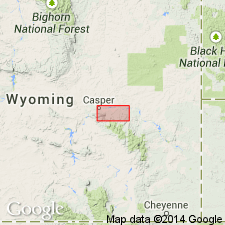
Named Teapot sandstone member of Pierre formation for Teapot Rock, a well-known topographic feature composed of this rock about half a mile east of the Casper-Salt Creek Road, Natrona Co, WY. Teapot Rock is [presumably] the type locality. Mapped along north side of Big Muddy dome in Natrona and Converse Cos, WY in the Wind River and Powder River basins. Wegemann described this as the sandstone that formed Little Pine Ridge, though he did not use the name. Name Little Pine Ridge sandstone considered cumbersome and not in current use. Name Teapot applied in preference. Teapot consists of gray to buff sandstone, carbonaceous shale, and thin coal beds that total about 160 ft thick. Overlain and underlain by unnamed parts of the Pierre. Assigned a Late Cretaceous age.
Source: GNU records (USGS DDS-6; Denver GNULEX).

- Usage in publication:
-
- Teapot Sandstone Member*
- Modifications:
-
- Overview
- AAPG geologic province:
-
- Wind River basin
Summary:
Used as a member of Mesaverde Formation in the southeastern Wind River basin and in Powder River basin, WY as the approximate equivalent of the Pine Ridge Sandstone. Is of late Campanian age. Relationship to other units of the same Late Cretaceous age in south-central WY shown on Table 1.
Source: GNU records (USGS DDS-6; Denver GNULEX).

- Usage in publication:
-
- Teapot Sandstone Member*
- Modifications:
-
- Areal extent
- AAPG geologic province:
-
- Powder River basin
Summary:
Mesaverde Formation identified in the subsurface of the western and southern Powder River basin (Converse, Niobrara, Johnson, Sheridan, western Campbell Cos, WY and Big Horn Co, MT) where it overlies Steele Shale and underlies Lewis Shale. Mesaverde divided into the Parkman Sandstone Member at base, unnamed middle part, and Teapot Sandstone Member at top. Eastward in the basin, the Steele, Mesaverde, and Lewis are replaced by Pierre Shale. The Parkman is the equivalent of the Red Bird Silty Member of the Pierre. Late Cretaceous age. [Shown on many cross sections in this OC series.]
Source: GNU records (USGS DDS-6; Denver GNULEX).
For more information, please contact Nancy Stamm, Geologic Names Committee Secretary.
Asterisk (*) indicates published by U.S. Geological Survey authors.
"No current usage" (†) implies that a name has been abandoned or has fallen into disuse. Former usage and, if known, replacement name given in parentheses ( ).
Slash (/) indicates name conflicts with nomenclatural guidelines (CSN, 1933; ACSN, 1961, 1970; NACSN, 1983, 2005, 2021). May be explained within brackets ([ ]).