

- Usage in publication:
-
- Sunshine Peak rhyolite*
- Modifications:
-
- Original reference
- Dominant lithology:
-
- Rhyolite
- AAPG geologic province:
-
- San Juan Mountains province
Summary:
[Credited to Larsen.] Sunshine Peak rhyolite. A local volcano poured out a considerable amount of this rhyolite on a regular surface of Silverton volcanic series in northwestern part of San Cristobal quadrangle and adjoining part of Uncompahgre quadrangle. Partly intrudes and partly unconformably overlies Picayune volcanic group. Confined to area about 12 miles across. Has a uniform and distinctive character; is commonly dense, nearly white to quaker drab. Its intrusive portions carry many large inclusions of Picayune volcanic group. Age is Miocene.
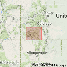
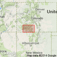
Named from exposures on Sunshine Peak, San Cristobal quadrangle, [Hinsdale Co.], southwestern CO.
Source: US geologic names lexicon (USGS Bull. 896, p. 2089).
- Usage in publication:
-
- Sunshine Peak Rhyolite*
- Modifications:
-
- Revised
- AAPG geologic province:
-
- San Juan Mountains province
Summary:
Newly assigned as the upper formation of Potosi Volcanic Group in the western San Juan Mountains, CO and in the San Juan Mountain province. Was previously unassigned to a group being recognized as a unit between the Silverton and Potosi Volcanic Groups. Use of Sunshine Peak in report area results in exclusion of Alboroto Rhyolite from the area. Is younger than Gilpin Peak Tuff (new) of Potosi. Is related to development of the Lake City caldera. Assigned to the middle and late Tertiary.
Source: GNU records (USGS DDS-6; Denver GNULEX).
- Usage in publication:
-
- Sunshine Peak Tuff*
- Modifications:
-
- Revised
- AAPG geologic province:
-
- San Juan Mountains province
Summary:
Removed from Potosi Volcanic Group (abandoned). Formerly thought to be the youngest unit of the Potosi. Known to be younger than Henson Formation and to overlie rocks called Potosi. Has a K-Ar age of 22.7 m.y. or Miocene. Is related to subsidence of the Lake City caldera. Had an estimated initial volume of 200-300 cubic km. Is preserved in and on the rim of the caldera, and on Jarosa Mesa in the San Juan Mountain province, CO.
Source: GNU records (USGS DDS-6; Denver GNULEX).
- Usage in publication:
-
- Sunshine Peak Tuff*
- Modifications:
-
- Age modified
- AAPG geologic province:
-
- San Juan Mountains province
Summary:
Age changed from Oligocene --to-- early Miocene; 22.5 m.y. Mapped in the north-central part of the quadrangle near Sunshine Peak, in T. 42 and 43 N., R. 4 and 5 W.; also in T. 41, 42, and 43 N., R. 3 and 4 W., Hinsdale County, Colorado (San Juan Mountain province). Considered part of /Potosi Volcanic Group† [Potosi Volcanic Group abandoned; see entry under Lipman and others (1973).]
Source: Modified from GNU records (USGS DDS-6; Denver GNULEX); Changes in stratigraphic nomenclature, 1974 (USGS Bull. 1405-A, p. A19-A20).
For more information, please contact Nancy Stamm, Geologic Names Committee Secretary.
Asterisk (*) indicates published by U.S. Geological Survey authors.
"No current usage" (†) implies that a name has been abandoned or has fallen into disuse. Former usage and, if known, replacement name given in parentheses ( ).
Slash (/) indicates name conflicts with nomenclatural guidelines (CSN, 1933; ACSN, 1961, 1970; NACSN, 1983, 2005, 2021). May be explained within brackets ([ ]).