The National Geologic Map Database is migrating to a new infrastructure. We apologize for any service disruptions during this process.
|
|---|


- Usage in publication:
-
- Sonyea formation
- Modifications:
-
- Named
- Dominant lithology:
-
- Shale
- AAPG geologic province:
-
- Appalachian basin
Summary:
The name Sonyea is applied to the combined Middlesex and Cashaqua, which are a natural unit, exposed on Cashaqua Creek, near Portage, NY. Unit is overlain by Attica (combined Rhinestreet and Hatch), and included in Nunda group.
Source: GNU records (USGS DDS-6; Reston GNULEX).
- Usage in publication:
-
- Sonyea Formation*
- Modifications:
-
- Areal extent
- AAPG geologic province:
-
- Appalachian basin
Summary:
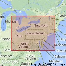
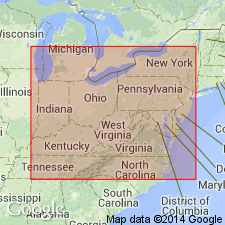
Sonyea Formation (as its Middlesex Shale Member) extended from southwestern NY and western PA into eastern OH, western MD, and WV.
Source: GNU records (USGS DDS-6; Reston GNULEX).

- Usage in publication:
-
- Sonyea Formation*
- Modifications:
-
- Overview
- AAPG geologic province:
-
- Appalachian basin
Summary:
In outcrop in western NY, the Sonyea consists of a basal black shale, the Middlesex Shale Member, and an upper gray shale with limestone nodules, the Cashaqua Shale Member. Members grade eastward into sequence of siltstone and silty shale, which is part of the general turbidite facies of the Catskill delta. The Middlesex is about 65 ft thick in the reference section 0.8 mi south of the village of Middlesex, Yates Co., NY. Thickens eastward to 75 ft at Chidsey Point Gully. Thins westward to 6 ft in Erie Co. Occurs in subsurface of PA, OH, WV, and MD, but is apparently is not present in VA. Makes up most of the Sonyea in the subsurface. The Cashaqua is thin, but recognizable from western NY, through PA and Garret Co., MD, to southwestern WV and has also been identified in southeastern OH. Age is Late Devonian.
Source: GNU records (USGS DDS-6; Reston GNULEX).
For more information, please contact Nancy Stamm, Geologic Names Committee Secretary.
Asterisk (*) indicates published by U.S. Geological Survey authors.
"No current usage" (†) implies that a name has been abandoned or has fallen into disuse. Former usage and, if known, replacement name given in parentheses ( ).
Slash (/) indicates name conflicts with nomenclatural guidelines (CSN, 1933; ACSN, 1961, 1970; NACSN, 1983, 2005, 2021). May be explained within brackets ([ ]).