The National Geologic Map Database is migrating to a new infrastructure. We apologize for any service disruptions during this process.
|
|---|


- Usage in publication:
-
- Socastee Formation
- Modifications:
-
- Original reference
- Dominant lithology:
-
- Sand
- Clay
- AAPG geologic province:
-
- Atlantic Coast basin
Summary:
Pg. 168-169. Socastee Formation. Forms surface of Myrtle Beach barrier system. Consists of a barrier facies, 10 to 30 feet thick, and backbarrier facies, up to 15 feet thick. Barrier facies, yellow to gray, well-sorted to moderately well-sorted, fine to coarse, unfossiliferous quartzose sands. Backbarrier facies, descending: (1) brown to gray, plastic kaolinitic-montmorillonitic clays, interpreted as mudflat and marsh deposits; (2) tan to gray, clayey silty sands locally containing vascular plant fragments, interpreted as probably mixed-estuarine and lagoonal deposits; and (3) gray to purple, blocky, vascular plant-bearing clays which grade laterally to lenses of sandy shell hash, interpreted as marsh- and tidal-flat channel deposits. Unconformably underlies Holocene deposits, notably "Waiter Island Formation" and "Ocean Forest Peat." Unconformably overlies Canepatch Formation along a sharp and moderately irregular contact. Corresponds in part to the Pamlico as mapped by Cooke, 1936 (USGS Bull. 867, 189 p., scale 1:500,000), and Doering, 1960 (Jour. Geol., v. 68, p. 182-202). Age is considered late Pleistocene, based on stratigraphic position.
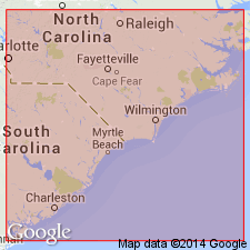
Type section (backbarrier facies): loc. WA-28, in northwest bank of Intracoastal Waterway near Socastee Swamp, approx. 0.2 mi southwest of U.S. Highway 501, [Myrtle Beach 7.5-min quadrangle], Horry Co., northeastern SC.
[Reference localities], subsurface and surface: (1) drillhole, loc. H-39, and adjacent exposures on south edge of Myrtle Beach, [Myrtle Beach 7.5-min quadrangle], Horry Co., northeastern SC; and (2) loc. WA-72, exposures at Hurl Rocks Beach, at seaward end of 20th Ave. S., Myrtle Beach, [Myrtle Beach 7.5-min quadrangle], Horry Co., northeastern SC.
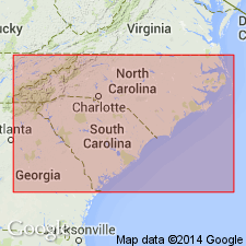
Forms narrow body 1 to 12 miles wide; borders present coast. Extends from Wilmington, NC, area southward to Santee River, SC.
Source: Publication; US geologic names lexicon (USGS Bull. 1520, p. 286).
- Usage in publication:
-
- Socastee Formation*
- Modifications:
-
- Revised
- Overview
- AAPG geologic province:
-
- Atlantic Coast basin
Summary:
Socastee Formation of DuBar and others (1974) adopted as redefined in this paper. Unconformably overlies Canepatch Formation; unconformably underlies Holocene deposits. Correlated with Flanner Beach (NC), Norfolk (VA), and Omar (DE) Formations. Age is late Pleistocene.
Source: GNU records (USGS DDS-6; Reston GNULEX).
- Usage in publication:
-
- Socastee Formation
- Modifications:
-
- Areal extent
- AAPG geologic province:
-
- Atlantic Coast basin
Summary:
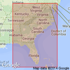
The Socastee Formation lies seaward of the Penholoway and Canepatch Formations and is the next younger surficial unit. Exposed in a belt approximately 25 km wide at elevations between 9 and 15 m above sea level. North of Charleston, SC, outcrop belt is well defined. Southward to the Savannah River, the Socastee lies at lower elevations in an outcrop belt that curves landward where it forms a pattern of "islands" surrounded by younger deposits. Near the Savannah River and into GA, the outcrop belt narrows. Sequence is composed mostly of interbedded sands and clays of backbarrier and barrier origin. Age is middle Pleistocene based on isotopic ages of about 200 ka. In northern NC unit is correlated with the Flanner Beach Formation and tentatively with the Shirley Formation and Sedgefield Member of the Tabb Formation.
Source: GNU records (USGS DDS-6; Reston GNULEX).
For more information, please contact Nancy Stamm, Geologic Names Committee Secretary.
Asterisk (*) indicates published by U.S. Geological Survey authors.
"No current usage" (†) implies that a name has been abandoned or has fallen into disuse. Former usage and, if known, replacement name given in parentheses ( ).
Slash (/) indicates name conflicts with nomenclatural guidelines (CSN, 1933; ACSN, 1961, 1970; NACSN, 1983, 2005, 2021). May be explained within brackets ([ ]).