The National Geologic Map Database is migrating to a new infrastructure. We apologize for any service disruptions during this process.
|
|---|


- Usage in publication:
-
- Silver Plume granite*
- Modifications:
-
- Named
- Dominant lithology:
-
- Granite
- AAPG geologic province:
-
- Southern Rocky Mountain region
Summary:
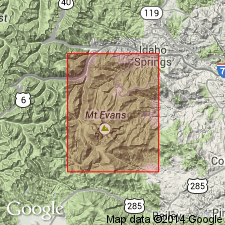
Name applied to granite that forms stocks, dikes, and irregular masses found in vicinity of Georgetown, on Alps Mountain, and in south wall of Clear Creek canyon at town of Silver Plume (source of name), Clear Creek Co, CO in the Southern Rocky Mountain region. The granite is medium-grained hypidiomorphic granular rock with pinkish-white porphyritic feldspar. Where locally rich in biotite, the color is dark gray mottled by pink feldspar. Distinguished from older granitic rocks in area by its larger porphyritic feldspars and smaller quartz feldspar and biotite. Consists (in order of decreasing abundance) of alkali feldspar, quartz, biotite and oligoclase, and oligoclase-albite. Zircon and apatite are abundant accessory minerals. Cuts all pre-Cambrian rocks in area--the Idaho Springs formation (new), the unnamed quartz monzonite gneiss, gneissoid granite, quartz-bearing diorite, and quartz monzonite, and the Rosalie granite (new)--except for some unnamed granite-porphyry, pegmatite, and associated granites. Pre-Cambrian age.
Source: GNU records (USGS DDS-6; Denver GNULEX).
- Usage in publication:
-
- Silver Plume Quartz Monzonite*
- Modifications:
-
- Mapped 1:24k (Tungsten quad, Boulder, Gilpin, and Jefferson Cos, CO)
- Redescribed
- Dominant lithology:
-
- Quartz Monzonite
- AAPG geologic province:
-
- Southern Rocky Mountain region
Summary:
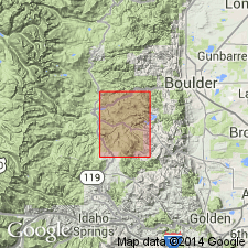
Is younger Precambrian formation mapped in northern part of quadrangle in south-central Boulder Co, CO (Southern Rocky Mountain region). Redescribed as a quartz monzonite (Silver Plume Granite of previous reports). Map unit described as pinkish-gray to light-tan, fine- to medium-grained, equigranular quartz monzonite, composed of potassium feldspar, oligoclase, quartz, and subordinate biotite and muscovite. Contains tabular feldspars that have a well-defined alignment characteristic of the Silver Plume elsewhere. Unless this feldspar alignment is conspicuous, Silver Plume rocks are easily confused with the biotite-quartz monzonite of Boulder Creek affinity. Both are two-mica quartz monzonites in which mafic minerals make up less than 10 percent of the rock. Silver Plume, as dikes, cuts the Boulder Creek batholith in the north and northeastern part of the quadrangle. Shown as younger Precambrian, younger than the Boulder Creek Granodiorite. The Silver Plume has been dated by Peterman, Hedge, and Braddock (1968) at about 1.4 b.y.
Source: GNU records (USGS DDS-6; Denver GNULEX).
- Usage in publication:
-
- Silver Plume Quartz Monzonite*
- Modifications:
-
- Mapped 1:24k (Evergreen quad, Jefferson Co, CO)
- Dominant lithology:
-
- Quartz Monzonite
- AAPG geologic province:
-
- Southern Rocky Mountain region
Summary:
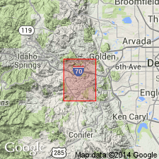
Is Precambrian Y formation mapped in southern part of the quadrangle in west-central Jefferson Co, CO (Southern Rocky Mountain region). Is the youngest Precambrian bedrock unit mapped in the quadrangle. Map unit described as quartz monzonite, gray to pinkish-buff rock composed principally of quartz, microcline, and plagioclase, with lesser amounts of biotite and muscovite. Commonly medium-grained, but locally grades to fine- or coarse-grained varieties. Texture of much of the rock is seriate porphyritic, with lath-shaped phenocrysts of Carlsbad-twinned microcline; locally, where such laths are sparse, the rock is more equigranular. In parts of the rock, planar alignment of microcline laths forms a weak to strong foliation; in other parts of the rock the microcline laths are diversely oriented. Occurs as irregular plutons, lenticular bodies, dikes, and sills. Inclusions of metamorphic rocks, especially biotite gneiss, are common. Rb-Sr determinations on samples from northeast of Sky Village in the Indian Hills quadrangle (southeast of the Evergreen quadrangle) fit 1,440 m.y. isochron of the Silver Plume Granite (Hedge, 1969). [Includes the type area of the Troutdale Granite (obsolete) of Underhill (1906) about 1 mi west of Evergreen Lake.]
Source: GNU records (USGS DDS-6; Denver GNULEX).
- Usage in publication:
-
- Silver Plume Quartz Monzonite*
- Modifications:
-
- Mapped 1:24k (Indian Hills quad, Jefferson Co, CO)
- Dominant lithology:
-
- Quartz monzonite
- Granite
- AAPG geologic province:
-
- Southern Rocky Mountain region
Summary:
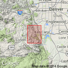
Is Precambrian Y [Middle Proterozoic] lithodeme mapped in central Jefferson Co, CO (Southern Rocky Mountain region). Outcrops as irregular discordant plutons and as numerous irregular dikes in country rock in western part of quad. Age relation to Precambrian lamprophyre is uncertain; older than Fountain Formation (Pennsylvanian and Permian); younger than coarse-grained pegmatite and granitic rock map units (Precambrian X and Y [Early and Middle Proterozoic]). Map unit described as massive light-colored coarse-grained muscovite-biotite quartz monzonite and granite containing lath-shaped Carlsbad-twinned potassic feldspar phenocrysts as much as 5 cm long. Contains inclusions of migmatite and biotite gneiss. Dikes generally are medium grained and many are not markedly porphyritic. Rb/Sr age determinations on samples from northeast of Sky Village fit 1440 m.y. isochron of Silver Plume.
Source: GNU records (USGS DDS-6; Denver GNULEX).
- Usage in publication:
-
- Silver Plume Quartz Monzonite*
- Modifications:
-
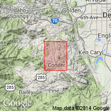
- Mapped 1:24k (Conifer quad, Douglas and Jefferson Cos, CO)
- Dominant lithology:
-
- Quartz monzonite
- AAPG geologic province:
-
- Southern Rocky Mountain region
Summary:
Is Precambrian Y [Middle Proterozoic] lithodeme mapped in west-central Jefferson Co, CO (Southern Rocky Mountain region). Is oldest formal lithodemic unit in quad. On Correlation of Map Units is shown to be younger than three informal Precambrian X [Early Proterozoic] lithodemic intrusive units and to be older than Pikes Peak Granite (Precambrian Y). Unit outcrops extensively over entire quad. Silver Plume is described as coarse-grained to fairly fine grained light-gray to moderate-orange-pink muscovite-biotite quartz monzonite. Typical coarse-grained variety has tabular Carlsbad-twinned potassic feldspar phenocrysts 0.5-1 cm long. Locally foliated. Contains numerous inclusions of migmatite, biotite gneiss, and sillimanite muscovite-biotite schist. Forms large slabby outcrops and thin sandy soil. Rb-Sr age determinations of 1,440 m.y. (Hedge, 1969, unpub. PhD. dissert., Colorado School of Mines).
Source: GNU records (USGS DDS-6; Denver GNULEX).
- Usage in publication:
-
- Silver Plume Quartz Monzonite*
- Modifications:
-
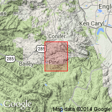
- Mapped 1:24k (Pine quad, Jefferson Co, CO)
- Dominant lithology:
-
- Quartz monzonite
- AAPG geologic province:
-
- Southern Rocky Mountain region
Summary:
Is Precambrian Y [Middle Proterozoic] lithodeme mapped in west-central Jefferson Co, CO (Southern Rocky Mountain region). Is oldest formal lithodemic unit in quad. On Correlation of Map Units is shown to be younger than three informal Precambrian X [Early Proterozoic] lithodemic units and to be older than Pikes Peak Granite (Precambrian Y). Unit outcrops in northeast and northwest parts of quad. Silver Plume is described as coarse-grained to fairly fine grained muscovite-biotite quartz monzonite. Typical coarse-grained variety has tabular Carlsbad-twinned potassic feldspar phenocrysts 0.5-1 cm long. Locally foliated. Contains numerous inclusions of migmatite. Forms large slabby outcrops and thin sandy soil. Rb-Sr age determinations of 1,440 m.y. (Hedge, 1969, unpub. PhD. dissert., Colorado School of Mines).
Source: GNU records (USGS DDS-6; Denver GNULEX).
- Usage in publication:
-
- Silver Plume Granite*
- Modifications:
-
- Overview
- AAPG geologic province:
-
- Southern Rocky Mountain region
Summary:
Also known as Silver Plume Quartz Monzonite. Occurs in central CO in the Southern Rocky Mountain region in several batholiths and many minor bodies in Front Range. Is leading example of granites of circa 1,400 m.y. age group.
Source: GNU records (USGS DDS-6; Denver GNULEX).

- Usage in publication:
-
- Silver Plume Granite*
- Modifications:
-
- Geochronologic dating
- AAPG geologic province:
-
- Southern Rocky Mountain region
Summary:
Pg. 12, geologic time scale (inside front cover). Silver Plume Granite. Sample from sec. 10, T. 7 S., R. 80 W., Lat. 39 deg. 27 min. 30 sec. N., Long. 106 deg. 20 min. 00 sec. W., Pando quadrangle, Eagle County, Colorado, yielded a K-Ar age of 1,150 +/-30 Ma (biotite). Age calculated using decay constants of Steiger and Jager, 1977 (Earth Planet. Sci. Letters, v. 36, p. 359-362). Age may indicate a time of uplift and cooling, but not time of intrusion. Silver Plume Granite is 1,450 Ma (Peterman and others, 1968) [Precambrian Y].
Source: Publication.
- Usage in publication:
-
- Silver Plume Quartz Monzonite*
- Modifications:
-
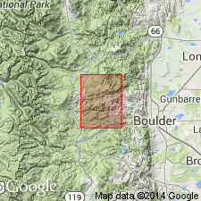
- Mapped 1:24k (Gold Hill quad, Boulder Co, CO)
- Dominant lithology:
-
- Quartz Monzonite
- AAPG geologic province:
-
- Southern Rocky Mountain region
Summary:
Is Precambrian Y unit mapped as two separate map units in central Boulder Co, CO (Southern Rocky Mountain region). Mapped as Silver Plume Quartz Monzonite (Ysp) and Migmatitic Silver Plume Quartz Monzonite (Yspb). Unit Ysp described as gray to buff, commonly medium- to coarse-grained rock but grades from fine- to coarse-grained seriate porphyry and is characterized by the alignment of tabular, Carlsbad-twinned feldspar. Composed principally of microcline, plagioclase, and quartz with lesser amounts of biotite and muscovite. Sillimanite in trace amounts is found throughout much of the Silver Plume Quartz Monzonite. Forms dikes, lenses, and plutons; some dikes are gradational along strike into a quartz monzonite similar to map unit Xqm (Precambrian X quartz monzonite) or individual bodies are gradational into Yspb. Locally contains pegmatite lenses or dikes. Locally areas of numerous Precambrian X biotite gneiss pods and lenses too small to map. Unit Yspb described as gray to orange-buff, fine- to medium grained, strongly foliated, and migmatitic quartz monzonite; completely gradational with unit Ysp. Migmatite probably derived from sillimanite-biotite gneiss unit. Composed chiefly of quartz, microcline, and plagioclase, and minor biotite. Biotite is more profuse in the migmatitic quartz monzonite than in the Silver Plume Quartz Monzonite and occurs in stringers, clots, and in dark biotitic layers. The characteristic tabular feldspar of Ysp is much less evident. Migmatitic unit crops out in the northernmost part of the quadrangle.
Source: GNU records (USGS DDS-6; Denver GNULEX).
- Usage in publication:
-
- Silver Plume Granite*
- Modifications:
-
- Revised
- Overview
- Geochronologic dating
- AAPG geologic province:
-
- Southern Rocky Mountain region
Summary:
Also called Silver Plume Quartz Monzonite. Is one of ten named units of the Middle Proterozoic Berthoud Plutonic Suite (new). Consists of light colored, medium-grained to seriate porphyritic and is generally structureless. Occurs in three batholiths and numerous smaller plutons in central and northern Front Range, CO in the Southern Rocky Mountain region. Is approximately equivalent to Cripple Creek Granite. Rb-Sr ages of 1,325 to 1,420 +/-30 m.y. reported.
Source: GNU records (USGS DDS-6; Denver GNULEX).
- Usage in publication:
-
- Silver Plume Granite*
- Modifications:
-
- Areal extent
- Overview
- AAPG geologic province:
-
- Southern Rocky Mountain region
Summary:
Extended into Strawberry Lake area, northwestern flank of central Front Range, Grand Co, CO, Southern Rocky Mountain region. Underlies about 20 percent of study area. Younger than Early Proterozoic biotite gneiss and Boulder Creek Granodiorite which respectively underlie 20 percent and 50 percent of area (granitic enclaves make up most of remainder of rocks in study area). Replaces some of 1700 m.y. old granitic rocks as shown on Geologic Map of Colorado, compiled by Tweto (1979) and some of Boulder Creek Granodiorite as mapped by Tweto (1987). Geochemistry; petrologic data; geologic map. In Strawberry Lake area, Silver Plume is more felsic than average and contains slightly more uranium and thorium than average elsewhere in Front Range. Chemical, geologic and petrologic evidence strongly suggests origin in Strawberry Lake area is metamorphic-metasomatic rather than magmatic. Partial melting probably occurred to some extent, however, no evidence has been found for gross intrusion. Rb-Sr age of 1503 +/-100 m.y. (Middle Proterozoic).
Source: GNU records (USGS DDS-6; Denver GNULEX).
For more information, please contact Nancy Stamm, Geologic Names Committee Secretary.
Asterisk (*) indicates published by U.S. Geological Survey authors.
"No current usage" (†) implies that a name has been abandoned or has fallen into disuse. Former usage and, if known, replacement name given in parentheses ( ).
Slash (/) indicates name conflicts with nomenclatural guidelines (CSN, 1933; ACSN, 1961, 1970; NACSN, 1983, 2005, 2021). May be explained within brackets ([ ]).