

- Usage in publication:
-
- Shawnee Island Member*
- Modifications:
-
- Named
- Dominant lithology:
-
- Limestone
- AAPG geologic province:
-
- Appalachian basin
Summary:
Pg. 2 (fig. 1), 21-25, 58-60, 61-63, pl. 1. Shawnee Island Member of Coeymans Formation of Helderberg Group. Composed of a biohermal and a nonbiohermal facies. More prevalent nonbiohermal facies consists of medium-gray, fine- to medium-grained, argillaceous and arenaceous, slightly limonitic, irregularly bedded limestone that has weak fracture cleavage and weathers medium-light-tannish-gray. Contains 1 to 30 percent quartz sand, and uppermost 10 to 25 feet contains nodules and lenses of dark-gray chert. Crinoid columnals and the brachiopod GYPIDULA COEYMANENSIS are abundant. Biohermal facies is a very coarse-grained to coarse-grained, medium-light-gray to light-pinkish-gray, slightly limonitic, unbedded to crudely bedded biogenic limestone that weathers light-gray and forms large spheroidal blocks upon weathering. Biohermal facies recognized at 4 localities in Milford, Lake Maskenozha, Flatbrookville, and Bushkill quadrangles. Corals, bryozoans, and crinoid columnals dominate the fauna, but there are sporadic occurrences of GYPIDULA COEYMANENSIS and other brachiopods. Member present in Pennsylvania, New Jersey, and New York. Thickness is variable because of its disconformable relation with overlying Stormville Member and as a result of local development of bioherms; is 56.1 feet thick at type section. Northeast of Wallpack Center, New Jersey, the Shawnee Island grades up into the cherty, more argillaceous Kalkberg Limestone. Southwest of Wallpack Center, the Kalkberg is more arenaceous and grades into the Shawnee Island, and in western part of Stroudsburg quadrangle, where Kalkberg is absent, the Shawnee Island disconformably underlies conglomerates of the Stormville. Northeast of Peters Valley, New Jersey, the Shawnee Island overlies Thacher Member of Manlius Limestone; contact is gradational except in a few places where biostromal layers at top of Thacher are present. Southwest of Peters Valley, Peters Valley Member (new) intervenes between the Depue (new) and Shawnee Island Members and grades up into the latter. Northeast of Nearpass quarries, New Jersey, the Shawnee Island grades laterally into Ravena Member. This transition takes place over a distance of 3 miles along strike between Nearpass quarries and Trilobite Mountain, New York. To facilitate mapping, an arbitrary cutoff northeast of Nearpass quarries was used to separate these two members. Age is Early Devonian. Report includes measured sections. (Shawnee Island Member of Coeymans Formation of Helderberg Group adopted by the USGS.)
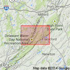
Type section: in cut along northwest side of road, 0.6 mi southwest of Shawnee on Delaware, in southwest corner of Bushkill 7.5-min quadrangle [approx. Lat. 41 deg. 0.5 min. N., Long. 75 deg. 6.92 min. W., Monroe Co., PA (A.G. Harris, written commun., ca. 1995)]. Named from Shawnee Island in the Delaware River, Monroe Co., PA.
Reference section: in woods on northeast side of secondary road along ascent of Wallpack Ridge in PA, immediately southwest of where the Delaware River cuts through the ridge, Flatbrookville quadrangle.
Source: Publication; US geologic names lexicon (USGS Bull. 1350, p. 684-685); GNU records (USGS DDS-6; Reston GNULEX); Changes in stratigraphic nomenclature, 1967 (USGS Bull. 1274-A, p. A18).
- Usage in publication:
-
- Shawnee Island Member
- Modifications:
-
- Overview
- AAPG geologic province:
-
- Appalachian basin
Summary:
Coeymans Formation in mapped area includes basal Depue Member, Shawnee Island Member, and Stormville Member. Shawnee Island occurs southwest of Wallpack Center where it grades into Kalkberg Limestone. Member is medium-gray, medium- to coarse-grained limestone; medium-bedded, flaggy to massive, with local bioherms. Members are not separately mapped. Total thickness of all units is about 90 ft. Age is Early Devonian.
Source: GNU records (USGS DDS-6; Reston GNULEX).
For more information, please contact Nancy Stamm, Geologic Names Committee Secretary.
Asterisk (*) indicates published by U.S. Geological Survey authors.
"No current usage" (†) implies that a name has been abandoned or has fallen into disuse. Former usage and, if known, replacement name given in parentheses ( ).
Slash (/) indicates name conflicts with nomenclatural guidelines (CSN, 1933; ACSN, 1961, 1970; NACSN, 1983, 2005, 2021). May be explained within brackets ([ ]).