The National Geologic Map Database is migrating to a new infrastructure. We apologize for any service disruptions during this process.
|
|---|


- Usage in publication:
-
- San Isabel Granite
- Modifications:
-
- Named
- Dominant lithology:
-
- Granite
- AAPG geologic province:
-
- Southern Rocky Mountain region
Summary:
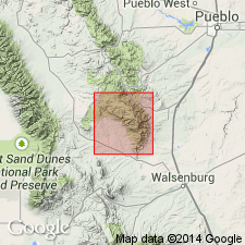
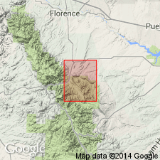
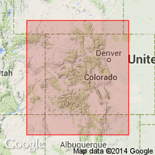
Named. No type locality designated. Has two distinct facies of one granite: coarse, porphyritic granite which crops out as large bluffs and ridges; and a uniform medium-grained phase. Contacts with migmatite and lit-par-lit gneiss are sharp in southern Custer and northern Huerfano Cos in Southern Rocky Mountain region. Covers 20 sq mi in northern part of southern Wet Mountains. Includes a batholith and several satellite bodies. Assigned to Precambrian.
Source: GNU records (USGS DDS-6; Denver GNULEX).
- Usage in publication:
-
- San Isabel Granite*
- Modifications:
-
- Age modified
- AAPG geologic province:
-
- Southern Rocky Mountain region
Summary:
Emplaced at about the same time as the Silver Plume Quartz Monzonite (1,450 m.y.), and assigned to Precambrian Y in the Southern Rocky Mountain region.
Source: GNU records (USGS DDS-6; Denver GNULEX).
- Usage in publication:
-
- San Isabel Granite*
- Modifications:
-
- Overview
- AAPG geologic province:
-
- Southern Rocky Mountain region
Summary:
Occurs in a small batholith in Wet Mountains, Huerfano and Pueblo Cos, CO, Southern Rocky Mountain region. U-Pb age of circa 1,400 m.y.
Source: GNU records (USGS DDS-6; Denver GNULEX).
- Usage in publication:
-
- San Isabel Granite*
- Modifications:
-
- Revised
- AAPG geologic province:
-
- Southern Rocky Mountain region
Summary:
Name applied to a coarse-grained porphyritic biotite granite or quartz monzonite; assigned with unnamed units and ten named units to Middle Proterozoic Berthoud Plutonic Suite, a new lithodemic unit defined in this report. Boyer (1962) studied main part of batholith; Taylor (1974) and Scott and others (1978) identified limits of batholith. Known in a pluton about 195 km (75 sq mi) and in a few smaller plutons in Wet Mountains, Huerfano and Pueblo Cos, CO, and south-central CO in the Southern Rocky Mountain region. Entire main pluton is considered the type area. Zr from granite has a U-Pb age of about 1,380 m.y., or Middle Proterozoic.
Source: GNU records (USGS DDS-6; Denver GNULEX).
For more information, please contact Nancy Stamm, Geologic Names Committee Secretary.
Asterisk (*) indicates published by U.S. Geological Survey authors.
"No current usage" (†) implies that a name has been abandoned or has fallen into disuse. Former usage and, if known, replacement name given in parentheses ( ).
Slash (/) indicates name conflicts with nomenclatural guidelines (CSN, 1933; ACSN, 1961, 1970; NACSN, 1983, 2005, 2021). May be explained within brackets ([ ]).