

- Usage in publication:
-
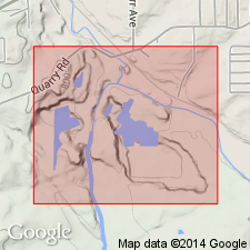
- Salem limestone
- Modifications:
-
- Named
- Dominant lithology:
-
- Limestone
- AAPG geologic province:
-
- Cincinnati arch
Cumings, E.R., 1901, The use of Bedford as a formational name: Journal of Geology, v. 9, p. 232-233.
Summary:
Named Salem limestone. Replaces Bedford which is preoccupied. Spergen Hill has also been used but rock in Salem vicinity is more typical of the formation. Base of Salem is at top of Bryozoan limestone which occurs at top of Harrodsburg limestone.
Source: GNU records (USGS DDS-6; Reston GNULEX).
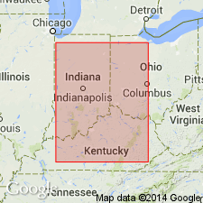
- Usage in publication:
-
- Salem limestone
- Modifications:
-
- Areal extent
- AAPG geologic province:
-
- Cincinnati arch
Summary:
Salem limestone is traced from Harrodsburg, Monroe Co., IN, southward to Somerset, Pulaski Co., KY. It is 65 ft thick at Harrodsburg and about 49 ft thick at Somerset. The Somerset shale member of the Warsaw formation of Butts (1922) assigned as basal member of Salem. It is apparently also recognized from Monroe Co., IN, to Pulaski Co., KY.
Source: GNU records (USGS DDS-6; Reston GNULEX).
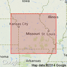
- Usage in publication:
-
- Salem formation
- Modifications:
-
- Overview
- AAPG geologic province:
-
- Illinois basin
Summary:
The Salem formation is best exposed and thickest in the east-central and southeastern parts of MO in St. Louis, Ste. Genevieve, and eastern Perry Cos., where it is 100 to 160 ft thick. The Salem thins northward from St. Louis Co. In the northeastern part of the State it ranges from 20 to 40 ft thick. It has been tentatively identified in central and western MO. The Salem is commonly composed of limestone, fossiliferous, oolitic, and argillaceous. Dolomitic in part. Chert occurs in places. Cross-bedding is common. Underlain by Warsaw formation, overlain by St. Louis formation. Age is Mississippian, Meramecian Series.
Source: GNU records (USGS DDS-6; Reston GNULEX).
- Usage in publication:
-
- Salem Limestone*
- Modifications:
-
- Overview
- AAPG geologic province:
-
- Cincinnati arch
Summary:
The Salem Limestone consists of limestone and shale. Limestone occurs predominantly as two varieties, very coarse grained and fine grained. The very coarse-grained type is pale yellowish brown to pale brown (weathered), silty; commonly cross-bedded in sets a few inches to 3 feet thick; contains scattered to very abundant brachiopods, fenestrate bryozoans, foraminifers, horn corals, crinoid columnals, gastropods, trilobites, and blastoid calyxes. The fine-grained type is yellowish gray to pale brown (weathered), silty, unfossiliferous to sparsely fossiliferous, in even beds 0.5 to 2 ft thick that do not appear to be cross-bedded. Most of the upper half of the formation is composed of the fine-grained limestone. Shale is medium gray, calcareous, silty, imperfectly fissile; contains abundant fossil fragments; makes up most of lower 20 ft of formation where it is interbedded with varying amounts of very coarse grained limestone. Shale also occurs as partings in remainder of formation. Underlain by Harrodsburg Limestone with a sharp to gradational contact. Overlain by St. Louis Limestone with gradational contact. Age is Mississippian.
Source: GNU records (USGS DDS-6; Reston GNULEX).
- Usage in publication:
-
- Salem Limestone
- Modifications:
-
- Overview
- AAPG geologic province:
-
- Illinois basin
Summary:
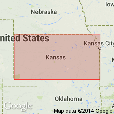
(Paleozoic Era; [Cambrian through Mississippian Systems] by E.D. Goebel, p. 20.) In northeastern Kansas, Salem Limestone consists mainly of noncherty or sparsely cherty saccharoidal to silty dolomite interstratified with noncherty calcarenite, which in some places constitutes the greater part of the formation. The Foraminifera ENDOTHYRA BAILEYI commonly is present. In southwestern Kansas, the Salem consists mainly of coarsely crystalline oolitic limestone and saccharoidal dolomite, dolomitic limestone, and chert. Thickness of Salem is about 50 feet in deepest part of the Salem basin, where it underlies Pennsylvanian rocks, and in the Forest City basin, where it underlies the St. Louis Limestone. In the Hugoton embayment, it is about 200 feet thick. Age is Late Mississippian (Meramecian).
Source: GNU records (USGS DDS-6; Reston GNULEX).
- Usage in publication:
-
- Salem Limestone*
- Modifications:
-
- Overview
- AAPG geologic province:
-
- Cincinnati arch
Summary:
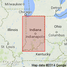
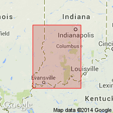
Salem Limestone is present in Indiana from the Ohio River in Harrison Co. (southeastern IN) to near the Montgomery-Park Co. boundary (west-central IN) and southwestward into the IL basin. It is 50 to 100 ft thick in southeast IN. Increases in thickness to southwest to 360 ft in Posey Co. (southwesternmost IN). Composed mostly of fossiliferous calcarenite. Underlain by Harrodsburg Limestone, overlain by St. Louis Limestone. Age is Mississippian, Valmeyeran Series.
Source: GNU records (USGS DDS-6; Reston GNULEX).

- Usage in publication:
-
- Salem Limestone
- Modifications:
-
- Overview
- AAPG geologic province:
-
- Illinois basin
Summary:
Salem Limestone occurs in southern IL being thickest, about 500 ft, in southeastern IL and thinning north and west. It crops out near the Mississippi River in western IL and in easternmost IL near the north-south middle. It is a biocalcarenite consisting of rounded, broken, fossil fragments and whole small fossils, commonly with banded, oolitic-like overgrowths that are embedded in a matrix that ranges from micrite to sparite. Endothyrid foraminifers are commonly abundant. Minor lithologies in the Salem include biocalcilutite, biocalcirudite, sucrosic dolomite, dolomitic limestone, sandstone, chert, and the evaporites, anhydrite and gypsum. In outcrop area in western IL, divided into Kidd, Fults, Chalfin and Rocher Members, ascending. Generally overlies the Ullin Limestone. Rests on Warsaw Shale or Sonora Formation northward where the Ullin pinches out. Overlain by St. Louis Limestone. Age is Mississippian, Valmeyeran Series.
Source: GNU records (USGS DDS-6; Reston GNULEX).

- Usage in publication:
-
- Salem-Warsaw Formation
- Modifications:
-
- Revised
- AAPG geologic province:
-
- Appalachian basin
Summary:
The Salem and Warsaw Formations in the southwestern part of the study area are treated as one unit and are identified only from subsurface logs. Composed of gray shales and fossiliferous, locally dolomitic limestones. Thickness 0 to 90 m. Where massive limestones dominate, they are included in the overlying Mount Vernon member (new, informal) of the Slade Formation. Overlies Fort Payne Formation or, where absent, the Borden Formation. According to the author, formal nomenclature presented in this report has been accepted by the Kentucky Stratigraphic Nomenclature Committee. Report includes correlation charts, cross-sections, and measured sections.
Source: GNU records (USGS DDS-6; Reston GNULEX).
- Usage in publication:
-
- Salem Limestone*
- Modifications:
-
- Overview
- AAPG geologic province:
-
- Illinois basin
Summary:
Used as Mississippian (Valmeyeran) Salem Limestone of Sanders Group in IN. Authors follow usage of Droste and Carpenter (1990, Indiana State Department of Natural Resources, Geological Survey Bulletin 62).
Source: GNU records (USGS DDS-6; Reston GNULEX).
For more information, please contact Nancy Stamm, Geologic Names Committee Secretary.
Asterisk (*) indicates published by U.S. Geological Survey authors.
"No current usage" (†) implies that a name has been abandoned or has fallen into disuse. Former usage and, if known, replacement name given in parentheses ( ).
Slash (/) indicates name conflicts with nomenclatural guidelines (CSN, 1933; ACSN, 1961, 1970; NACSN, 1983, 2005, 2021). May be explained within brackets ([ ]).