The National Geologic Map Database is migrating to a new infrastructure. We apologize for any service disruptions during this process.
|
|---|


- Usage in publication:
-
- Roubidoux sandstone
- Modifications:
-
- Original reference
- Dominant lithology:
-
- Sandstone
- AAPG geologic province:
-
- Ozark uplift
Summary:
Pg. vii, 12, 93, 114-115. Roubidoux sandstone. Fossiliferous sandstones, overspreading Ozark region from Cabool to Gasconade City and from Salem to Doniphan, embracing much, if not all, of what has been called Second sandstone, and will undoubtedly include the areas of so-called First sandstone as well, which is believed to be same as Second sandstone. The Roubidoux is upper formation of Ozark series. Overlies Gasconade limestone, the lower formation of Ozark series. Age is Early Ordovician (Beekmantown).
Named from Roubidoux Creek, in Texas and Pulaski Cos., central MO.
Source: US geologic names lexicon (USGS Bull. 896, p. 1848).

- Usage in publication:
-
- Roubidoux sandstone
- Modifications:
-
- Areal extent
- AAPG geologic province:
-
- Ozark uplift
Keyes, C.R., 1894, Paleontology of Missouri, Part I: Missouri Geological Survey, v. 4, 271 p.
Summary:
Roubidoux sandstone, 0 to 75 feet thick, underlies First Magnesium limestone and unconformably overlies Second Magnesium limestone. Is = First or Saccharoidal sandstone and not believed = St. Peter sandstone. [Age is Early Ordovician (Beekmantown).]
Source: US geologic names lexicon (USGS Bull. 896, p. 1848).
- Usage in publication:
-
- Roubidoux sandstone
- Modifications:
-
- Areal extent
- AAPG geologic province:
-
- Ozark uplift
Summary:
Also Amer. Geol., v. 15, p. 81-89, 1895. Roubidoux sandstone or Saccharoidal sandstone. Overlies Jefferson City limestone, and is = Joachim limestone and Crystal City sandstone. [Age is Early Ordovician (Beekmantown).]
Source: US geologic names lexicon (USGS Bull. 896, p. 1848).
- Usage in publication:
-
- Roubidoux sandstone
- Modifications:
-
- Areal extent
- AAPG geologic province:
-
- Ozark uplift
Summary:
Pg. 63-70. Roubidoux sandstone underlies Jefferson City limestone and overlies Gasconade limestone. [Age is Early Ordovician (Beekmantown).]
Source: US geologic names lexicon (USGS Bull. 896, p. 1848).
- Usage in publication:
-
- Roubidoux sandstone
- Modifications:
-
- Areal extent
- AAPG geologic province:
-
- Ozark uplift
Summary:
Roubidoux sandstone, 100 feet thick, underlies Jefferson City limestone, overlies Gasconade limestone, and is = Moreau sandstone and St. Elizabeth in part. Age is Cambrian (Ozark).
Source: US geologic names lexicon (USGS Bull. 896, p. 1848).
- Usage in publication:
-
- Roubidoux formation
- Modifications:
-
- Areal extent
- AAPG geologic province:
-
- Ozark uplift
Summary:
Roubidoux formation. A complex of sandstone, chert, quartzite, dolomite, and shale, of uncertain thickness and areal extent. Thickness 70 to 225+ feet. Underlies Jefferson City limestone and overlies Gasconade limestone. Includes Bolin Creek sandstone member. Is = Second sandstone, Moreau sandstone, St. Elizabeth formation, and doubtfully Marshfield sandstone and Bolivar sandstone. [This is commonly accepted definition of Roubidoux formation.]
Source: US geologic names lexicon (USGS Bull. 896, p. 1848).
- Usage in publication:
-
- Roubidoux sandstone
- Modifications:
-
- Areal extent
- AAPG geologic province:
-
- Ozark uplift
Summary:
Pg. 3-9. Roubidoux sandstone of Nason, Winslow, and Marbut is = Bolin Creek sandstone, upper part of St. Elizabeth formation.
Source: US geologic names lexicon (USGS Bull. 896, p. 1848).
- Usage in publication:
-
- Roubidoux formation
- Modifications:
-
- Revised
- Areal extent
- AAPG geologic province:
-
- Ozark uplift
Summary:
Described Roubidoux formation of Morgan County, central Missouri, as consisting of (descending): (1) "Cotton rock" (fine-grained limestone); (2) Bolin sandstone member (persistent, consisting of 10 feet of gray and reddish sand, 8 to 15 feet of limestone and chert, and 10 feet of gray and reddish sand); (3) cherty magnesium limestone and chert; (4) sandstone in some places, heavy-bedded brecciated chert in other places. [Age is Early Ordovician (Beekmantown).]
Source: US geologic names lexicon (USGS Bull. 896, Bolin Creek entry p. 228).

- Usage in publication:
-
- Roubidoux formation
- Modifications:
-
- Overview
Branson, E.B., 1944, The geology of Missouri: University of Missouri Studies, v. 19, no. 3, 535 p.
Summary:
Pg. 47-50. Roubidoux formation. Interbedded sandstones and dolomites; variable in character; in some places is almost entirely sandstone; whereas in others it is mainly dolomite. Basal sandstone irregular in thickness, ranging from less than 1 foot up to 30 feet; color reddish-brown or sometimes gray. Thickness 160 to 170 feet. Fossiliferous; main fossil zone 60 to 70 feet above base. Overlies Gasconade formation; unconformably underlies Jefferson City formation.
Source: US geologic names lexicon (USGS Bull. 1200, p. 3344-3345).
- Usage in publication:
-
- Roubidoux formation
- Modifications:
-
- Contact revised
- AAPG geologic province:
-
- Ozark uplift
Summary:
Pg. 15. Roubidoux formation. Unconformably underlies Rich Fountain formation (new) of Jefferson City group. [Age is Early Ordovician.]
Source: US geologic names lexicon (USGS Bull. 1200, p. 3344-3345).
- Usage in publication:
-
- Roubidoux formation
- Modifications:
-
- Principal reference
- AAPG geologic province:
-
- Ozark uplift
Summary:
Roubidoux formation. As originally defined, Roubidoux did not have specific type section. Type section is herein designated. Thickness 150 feet at type section. Here formation overlies Gasconade and underlies Rich Fountain formation of Jefferson City group. May rest unconformably on Gasconade, but there is little field evidence to support this view; Roubidoux-Rich Fountain contact appears to be one of conformity. Systematic description of fauna. Age is Early Ordovician (early Canadian).
Type section: along southeast-facing hillside above Roubidoux Creek, in SE/4 NW/4 SW/4 sec. 10, T. 33 N., R. 12 W., Roby 7.5-min quadrangle, Texas Co., central MO. Widely distributed throughout most of Ozark uplift in MO.
Source: Publication; US geologic names lexicon (USGS Bull. 1200, p. 3344-3345).
- Usage in publication:
-
- Roubidoux Formation
- Modifications:
-
- Overview
Summary:
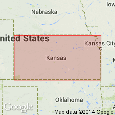
(Paleozoic Era; [Cambrian through Mississippian Systems] by E.D. Goebel, p. 13.) Roubidoux Formation. In Kansas, this formation consists mainly of sandy dolomite and fine-grained sandstone. Deposition of the Roubidoux seems to have been preceded by folding and erosion of older rocks. Thickness of the formation generally ranges from 150 to 200 feet.
Source: Publication.

- Usage in publication:
-
- Roubidoux Formation
- Modifications:
-
- Overview
- AAPG geologic province:
-
- Ozark uplift
Summary:
New Richmond Sandstone of Illinois is equivalent to lower part of Roubidoux Formation of Missouri.
Source: GNU records (USGS DDS-6; Reston GNULEX).

- Usage in publication:
-
- Roubidoux Formation*
- Modifications:
-
- Areal extent
- AAPG geologic province:
-
- Illinois basin
- Ozark uplift
Summary:
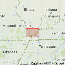
Roubidoux Formation is recognized in subsurface of St. Louis area, Missouri and Illinois.
Source: Modified from GNU records (USGS DDS-6; Reston GNULEX).
- Usage in publication:
-
- Roubidoux Formation*
- Modifications:
-
- Areal extent
- AAPG geologic province:
-
- Ozark uplift
Summary:
Roubidoux Formation is oldest outcropping rock in quadrangle. Occurs on Ozark dome in Missouri. In subsurface, sand content decreases eastward and it becomes difficult to distinguish from other formations. In subsurface of Illinois basin, equivalent sediments are assigned to Shakopee Dolomite. Age is Ordovician (Canadian).
Source: Modified from GNU records (USGS DDS-6; Reston GNULEX).

- Usage in publication:
-
- Roubidoux Formation*
- Modifications:
-
- Areal extent
- AAPG geologic province:
-
- Upper Mississippi embayment
- Illinois basin
Summary:
Roubidoux Formation mapped undivided with Gasconade Dolomite in subsurface of Upper Mississippi embayment in Missouri and Illinois basin of Illinois. Age is Early Ordovician (Canadian).
Source: GNU records (USGS DDS-6; Reston GNULEX).
For more information, please contact Nancy Stamm, Geologic Names Committee Secretary.
Asterisk (*) indicates published by U.S. Geological Survey authors.
"No current usage" (†) implies that a name has been abandoned or has fallen into disuse. Former usage and, if known, replacement name given in parentheses ( ).
Slash (/) indicates name conflicts with nomenclatural guidelines (CSN, 1933; ACSN, 1961, 1970; NACSN, 1983, 2005, 2021). May be explained within brackets ([ ]).