The National Geologic Map Database is migrating to a new infrastructure. We apologize for any service disruptions during this process.
|
|---|


- Usage in publication:
-
- Ralston Creek formation*
- Modifications:
-
- Mapped
- Dominant lithology:
-
- Claystone
- Limestone
- Siltstone
- Sandstone
- AAPG geologic province:
-
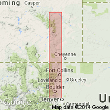
- Denver basin
Summary:
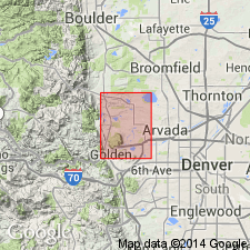
Ralston Creek formation. Shale-marlstone about 110 feet thick in Golden quadrangle, Jefferson County, north-central Colorado. At base of formation, a 5-foot-thick bed of grayish-red to light-gray fine- to medium-grained calcareous sandstone is exposed below highwater mark of Ralston Reservoir. This bed not indicated in sections measured by LeRoy (1946; p. 41, 51) of the Ralston and Lykins formations in Ralston Creek, and here tentatively assigned to Ralston Creek formation. Age is Late Jurassic.
Source: US geologic names lexicon (USGS Bull. 1200, p. 3194).
- Usage in publication:
-
- Ralston Creek formation*
- Modifications:
-
- Principal reference
- Dominant lithology:
-
- Shale
- Marlstone
- Sandstone
- Gypsum
- AAPG geologic province:
-
- Denver basin
Summary:
Pg. 755-756. Name Ralston Creek formation used in place of name Ralston formation as described by LeRoy (1946). Change in name desirable to avoid confusion because Ralston formation has been used previously for several different formations. Encompasses same rocks that were described by LeRoy (1946) as Ralston formation. Consists of varicolored claystone, siltstone, and limestone and contains thin beds and disseminated nodules of moderate-red to dark-gray chalcedony. Underlies Morrison formation; overlies Lykins formation. Age is Late Jurassic.
Type section: at the locality described by LeRoy (1946, p. 51), on south side of Ralston Creek in NW/4 SW/4 sec. 5, T. 3 S., R. 70 W., Ralston Buttes quadrangle. [LeRoy, 1946, p. 51 gives type section of shale-marlstone facies of Ralston formation as sec. 5, T. 3 S., R. 70 W., Blackhawk quadrangle.]
[see Ralston for references prior to 1957]
Source: US geologic names lexicon (USGS Bull. 1200, p. 3194).
- Usage in publication:
-
- Ralston Creek Formation*
- Modifications:
-
- Areal extent
- Overview
- AAPG geologic province:
-
- Las Vegas-Raton basin
Summary:
Questionable use of name extended south from Denver basin into Huerfano and Las Animas Cos, CO in Las Vegas-Raton basin. Is a thin (57 ft section measured on Purgatoire River) sequence of nonfossiliferous light-gray to green argillaceous to gypsiferous sandstone and siltstone, green claystone, gray limestone, and white gypsum. Jasper nodules and veinlets in several beds. Ranges from 16 to 69 ft thick. Overlies Entrada Sandstone; underlies Morrison Formation. Is of intermixed fresh-water, evaporite-basin and possibly shallow-water marine origin. Thought to be stratigraphically equivalent to the Todilto Limestone, Bell Ranch and Wanakah Formations. Of Late Jurassic age.
Source: GNU records (USGS DDS-6; Denver GNULEX).

- Usage in publication:
-
- Ralston Creek formation*
- Modifications:
-
- Mapped 1:24k (Littleton quad, Arapahoe, Douglas, and Jefferson Cos, CO)
- Dominant lithology:
-
- Siltstone
- Limestone
- AAPG geologic province:
-
- Denver basin
Summary:
Is Upper Jurassic formation mapped in east-central Jefferson Co, CO (Denver basin). Outcrops between hogbacks of Lyons sandstone and Lytle and South Platte formations and generally at bottoms of valleys in southwest part of quad. Ranges in thickness from 50 ft at south edge of quad to 98 ft at Deer Creek in adjacent Indian Hills quad to west. In southern part of map area Ralston Creek consists of 27 ft of yellowish-gray dense limestone beds, which contain nodules of black and red jasper, separated by silty calcareous shale in upper part and 23 ft of thin fine-grained sandstone interbedded with silty or sandy shale in lower part. Limestone beds contain fresh-water gastropods GYRAULUS VETERNUS and LYMNAEA MORRISONENSIS, and algae ECHINOCHARA SPINOSA. In northern part of area, upper 50 ft is primarily jasper-bearing greenish-gray and reddish-brown siltstone, with some thin beds of finely crystalline limestone, and fine-grained calcareous pale-reddish-brown sandstone which is underlain by laminated calcareous light-brown siltstone, and the lower 30 ft consists of gypsiferous siltstone and gypsum beds. Measured section. Overlies Lykins formation (Permian? and Triassic?); underlies Morrison formation (Upper Jurassic).
Source: GNU records (USGS DDS-6; Denver GNULEX).
- Usage in publication:
-
- Ralston Creek formation*
- Modifications:
-
- Mapped 1:24k (Kassler quad, Douglas and Jefferson Cos, CO)
- Dominant lithology:
-
- Shale
- Limestone
- Sandstone
- AAPG geologic province:
-
- Denver basin
Summary:
Is Upper Jurassic formation mapped in northwestern Douglas and southeastern Jefferson Cos, CO (Denver basin). Outcrops as northwesterly striking, northeast dipping, very narrow band along Hogback in central part of map. Map unit includes Entrada? sandstone equivalent. Described (p.92) as a series of yellowish-gray dense ridge-forming limestone beds separated by silty calcareous shale in upper part, and thin, fine-grained sandstone beds separated by silty or sandy shale in lower part. Contains fossils including fresh-water gastropods and algae. Unconformably overlies Lykins formation (Permian? and Triassic?); unconformably underlies Morrison formation (Upper Jurassic). Thickness is about 48 ft. Measured sections.
Source: GNU records (USGS DDS-6; Denver GNULEX).

- Usage in publication:
-
- Ralston Creek Formation*
- Modifications:
-
- Mapped 1:24k (Morrison quad, Jefferson Co, CO)
- Dominant lithology:
-
- Sandstone
- Siltstone
- Limestone
- AAPG geologic province:
-
- Denver basin
Summary:
Is Upper Jurassic formation mapped in north-central Jefferson Co, CO (Denver basin). Outcrops along Hogback. Unconformably overlies Strain Shale Member (Triassic? and Permian) of Lykins Formation; unconformably underlies Morrison Formation (Upper Jurassic). Described as purplish-gray sandstone and siltstone, underlain by grayish-yellow silty sandstone containing crystalline clayey limestone having red jasper and calcite crystals; thin layers of vermilion and white sandstone lie above base of formation. South of Turkey Creek, formation contains thick bed of gypsum. Thickness is 90 ft.
Source: GNU records (USGS DDS-6; Denver GNULEX).
- Usage in publication:
-
- Ralston Creek Formation*
- Modifications:
-
- Age modified
- AAPG geologic province:
-
- Denver basin
Summary:
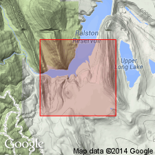
Shown as equivalent to Canyon Springs Sandstone Member of Sundance Formation and to the unconformably overlying lower part of Morrison Formation at Ralston Reservoir, Jefferson Co, CO in the Denver basin. The section at the reservoir is designated the type locality. Unconformably overlies Lykins Formation. Age changed from Late Jurassic to Middle and Late Jurassic on basis of stratigraphic position. Measured sections shown.
Source: GNU records (USGS DDS-6; Denver GNULEX).
- Usage in publication:
-
- Ralston Creek Formation*
- Modifications:
-
- Not used
Summary:
Name considered unnecessary. In the Front Range area, the sandstone at the base of the Ralston Creek Formation has been correlated with the Canyon Springs Sandstone Member of the Sundance Formation which is correlated in turn with the Entrada Sandstone. The overlying gypsum-bearing beds have been assigned to the Morrison Formation in the San Rafael Swell and Black Canyon embayments of the Windy Hill sea. Gypsiferous beds in the Front Range embayment that have been assigned to the upper part of the Ralston Creek Formation should be reassigned to the lower part of the Morrison Formation. An algal form, ACLISTOCHARA, found in the Ralston Creek Formation at Ralston Creek, is also found in the lower 40-50 ft of the Morrison.
Source: GNU records (USGS DDS-6; Denver GNULEX).
For more information, please contact Nancy Stamm, Geologic Names Committee Secretary.
Asterisk (*) indicates published by U.S. Geological Survey authors.
"No current usage" (†) implies that a name has been abandoned or has fallen into disuse. Former usage and, if known, replacement name given in parentheses ( ).
Slash (/) indicates name conflicts with nomenclatural guidelines (CSN, 1933; ACSN, 1961, 1970; NACSN, 1983, 2005, 2021). May be explained within brackets ([ ]).