The National Geologic Map Database is migrating to a new infrastructure. We apologize for any service disruptions during this process.
|
|---|


- Usage in publication:
-
- Port Ewen limestone
- Modifications:
-
- Named
- Dominant lithology:
-
- Limestone
- AAPG geologic province:
-
- Appalachian basin
Summary:
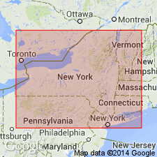
Name Port Ewen limestone introduced in this report for unit near Port Ewen, NY. [Replaces use of Kingston beds, preoccupied.] Described as somewhat shaly limestone, typically exposed, attaining thickness of 100 to 200 ft in vicinity of Port Ewen. Included in Helderbergian group. In Orange Co. sections, the fauna seems to graduate into that of the overlying Oriskany. Underlies Oriskany beds and overlies Becraft limestone. Age is Early Devonian.
Source: GNU records (USGS DDS-6; Reston GNULEX).
- Usage in publication:
-
- Port Ewen Shale*
- Modifications:
-
- Overview
- AAPG geologic province:
-
- Appalachian basin
Summary:
Port Ewen Shale of Helderberg Group used in area of report (northeastern Pennsylvania, New Jersey, and southeasternmost New York). Age is Early Devonian.
Source: Changes in stratigraphic nomenclature, 1967 (USGS Bull. 1274-A, p. A15).
- Usage in publication:
-
- Port Ewen Shale
- Modifications:
-
- Overview
- AAPG geologic province:
-
- Appalachian basin
Summary:
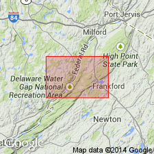
Port Ewen Shale of Helderberg Group mapped in northwestern NJ. Upper section is dark- to medium-dark-gray; calcareous siltstone and shale, fossiliferous. Lower section is medium-dark-gray, calcareous silty shale, irregularly bedded, nonfossiliferous. Thickness is approximately 150 ft. Lower contact with Minisink Limestone is abrupt and marked by the first occurrence of limestone. Underlies Glenerie Formation of Oriskany Group. Age is Early Devonian.
Source: GNU records (USGS DDS-6; Reston GNULEX).
For more information, please contact Nancy Stamm, Geologic Names Committee Secretary.
Asterisk (*) indicates published by U.S. Geological Survey authors.
"No current usage" (†) implies that a name has been abandoned or has fallen into disuse. Former usage and, if known, replacement name given in parentheses ( ).
Slash (/) indicates name conflicts with nomenclatural guidelines (CSN, 1933; ACSN, 1961, 1970; NACSN, 1983, 2005, 2021). May be explained within brackets ([ ]).