The National Geologic Map Database is migrating to a new infrastructure. We apologize for any service disruptions during this process.
|
|---|


- Usage in publication:
-
- Pine Canyon limestone*
- Modifications:
-
- First used
- Dominant lithology:
-
- Limestone
- AAPG geologic province:
-
- Wasatch uplift
- Great Basin province
Summary:
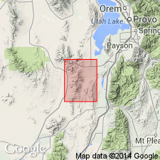
First published use. Intent to name, source of geographic name, and type locality not stated. Included as part of Godiva limestone by Tower and Smith (1899). Makes up most of Godiva Mountain, Sioux and Mammoth Peaks. Bounded on north and east by volcanic rocks. Overlies Gardner dolomite (first used). Base of formation placed at base of lowest chert bed. Thickness cannot be accurately stated; is 1,000 ft thick in one of the mine shafts. Consists of: 1) black dense thin-bedded limestone that contains large black chert nodules nearly 1 ft in diameter and a few thin beds of black chert; and 2) medium to light-gray, medium- to coarse-grained, cross-bedded limestone. Fossiliferous (corals). Assigned an Early and Late Mississippian age. Mapped (geologic map) in central part of Tintic mining district in T10S, Rs2 and 3W, in Utah Co on the Wasatch uplift, and Juab Co, UT in the Great Basin province.
Source: GNU records (USGS DDS-6; Denver GNULEX).

- Usage in publication:
-
- Pine Canyon limestone†
- Modifications:
-
- Abandoned
Summary:
Term Deseret limestone used in favor of Pine Canyon limestone. Base of Pine Canyon as defined by Loughlin (1919) was not placed consistently at the same horizon. Because of discrepancies between definition and application to rocks mapped, the Pine Canyon abandoned. Was formerly used in the Tintic district, Juab Co, UT in the Great Basin province and in Utah Co, UT on the Wasatch uplift.
Source: GNU records (USGS DDS-6; Denver GNULEX).
For more information, please contact Nancy Stamm, Geologic Names Committee Secretary.
Asterisk (*) indicates published by U.S. Geological Survey authors.
"No current usage" (†) implies that a name has been abandoned or has fallen into disuse. Former usage and, if known, replacement name given in parentheses ( ).
Slash (/) indicates name conflicts with nomenclatural guidelines (CSN, 1933; ACSN, 1961, 1970; NACSN, 1983, 2005, 2021). May be explained within brackets ([ ]).