

- Usage in publication:
-
- Peters Valley Member*
- Modifications:
-
- Named
- Dominant lithology:
-
- Sandstone
- Limestone
- AAPG geologic province:
-
- Appalachian basin
Summary:
Pg. 2 (fig. 1), 21, 57-60, 61-63, pl. 1. Peters Valley Member of Coeymans Formation of Helderberg Group. Varies laterally form medium-gray arenaceous limestone to light-medium-gray, fine- to coarse-grained, pebbly calcareous sandstone that weathers light-tannish-gray to medium-light-gray. Contains 15 to 65 percent subangular to subrounded quartz sand grains and is locally cross-bedded. Member present in New Jersey and Pennsylvania. Thickens gradually from a feather edge near Port Jervis, New York, to 9 feet at Shawnee on Delaware, Pennsylvania. Persists to southwest end of Godfrey Ridge in Saylorsville quadrangle. In most places, occurs as one massive bed and grades into the Shawnee Island Member (new) above and the Depue Limestone Member (new) below. Contains fragments of rugose corals, FAVOSITES sp., stromatoporoids, and brachiopods. Age is Early Devonian. Report includes measured sections. (Peters Valley Member of Coeymans Formation adopted by the USGS.)
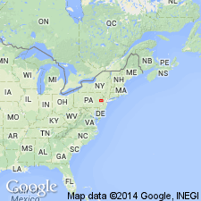
Type section: in roadcut on northwest side of county road that extends along southwest side of Wallpack Ridge, 1.5 mi northwest of Flatbrookville and 0.1 mi southwest of V-shaped bend in road, in northwest quarter of Flatbrookville quadrangle [approx. Lat. 41 deg. 06.7 min. N., Long. 74 deg. 56.86 min. W., Sussex Co., NJ (A.G. Harris, written commun., ca. 1995)]. Named from village of Peters Valley, NJ, 1.4 mi northeast of Wallpack Center.
Reference sections: (1) in cut along northwest side of road, 0.6 mi southwest of Shawnee on Delaware, in southwest corner of Bushkill 7.5-min quadrangle [approx. Lat. 41 deg. 0.5 min. N., Long. 75 deg. 6.92 min. W., Monroe Co., PA (A.G. Harris, written commun., ca. 1995)] =type section of Shawnee Island and Depue Limestone Members of Coeymans Formation; (2) in woods on northeast side of secondary road along ascent of Wallpack Ridge, immediately southwest of where Delaware River cuts through ridge, in northwest quarter of Flatbrookville quadrangle, Monroe Co., PA.
Source: Publication; US geologic names lexicon (USGS Bull. 1350, p. 570-571); GNU records (USGS DDS-6; Reston GNULEX); Changes in stratigraphic nomenclature, 1967 (USGS Bull. 1274-A, p. A15).
- Usage in publication:
-
- Peters Valley Member*
- Modifications:
-
- Overview
- AAPG geologic province:
-
- Appalachian basin
Summary:
Sandstone and conglomerate of the Peters Valley and Stormville Members of the Coeymans Formation thicken from Godfrey Ridge to Cherry Ridge at Bossardville, PA, where they are tongues extending northeastward and are the dominant lithic type of the Coeymans. The Stormville, the thicker of the two members, is raised in rank to Formation from Bossardville southward. In easternmost PA and NJ, the Stormville and Coeymans form a facies mosaic of four interfingering members of the Coeymans: (ascending) the Depue Limestone, Peters Valley, Shawnee Island, and Stormville Members.
Source: GNU records (USGS DDS-6; Reston GNULEX).
For more information, please contact Nancy Stamm, Geologic Names Committee Secretary.
Asterisk (*) indicates published by U.S. Geological Survey authors.
"No current usage" (†) implies that a name has been abandoned or has fallen into disuse. Former usage and, if known, replacement name given in parentheses ( ).
Slash (/) indicates name conflicts with nomenclatural guidelines (CSN, 1933; ACSN, 1961, 1970; NACSN, 1983, 2005, 2021). May be explained within brackets ([ ]).