

- Usage in publication:
-
- Ozan formation*
- Modifications:
-
- Named
- Dominant lithology:
-
- Marl
- Sand
- AAPG geologic province:
-
- Arkla basin
- Ouachita folded belt
Summary:
Named as formation in the Gulf series. [Presumably named for] town of Ozan, AR which stands on the outcrop. Typically exposed along the middle fork of Ozan Creek in vicinity of Ozan, Hempstead Co, AR. Underlies Annona chalk. Overlies Brownstone marl. Is divided into unnamed upper member and basal glauconitic sand named Buckrange sand lentil. Named as formation in the Gulf series. Formerly included in Brownstown formation of Veatch (1906), which is here restricted. Separated on basis of somewhat different lithology and unconformity at base. Consists of sandy micaceous marl; basal 3-8 ft is sandy marl or marly sand containing as much as 50 percent coarse glauconitic grains and locally with thin, highly polished pebbles and grains of black chert, phosphatic nodules, numerous shells, phosphatic casts, and shark teeth. The basal glauconitic sand is named Buckrange sand lentil of Ozan formation. A second glauconitic sandy marl occurs 50 ft higher in the section in Howard Co, AR and is also present in Little River and Sevier Co, AR. Upper part of Ozan is massive dark sandy micaceous marl with some beds of hard limestone and poorly bedded and cross-bedded, marly, very fine quartz sand. Thickness is 150-250 ft in Hempstead Co. and west; thins eastward. Unconformably overlies Brownstown marl. Transitional contact with overlying Annona chalk. Equivalent to the age of the typical Taylor marl (Upper Cretaceous).
Source: GNU records (USGS DDS-6; Denver GNULEX).

- Usage in publication:
-
- Ozan Formation
- Modifications:
-
- Mapped 1:250k
- Dominant lithology:
-
- Clay
- Sand
- Marl
- Limestone
- AAPG geologic province:
-
- Arkla basin
- East Texas basin
- Ouachita folded belt
Summary:
Ozan Formation. In Texas, clay, calcareous, some fine sand, bluish-gray; weathers light-gray; marine megafossils; thickness 425 feet. In Arkansas, upper part, marl, sandy, micaceous, some thin beds of hard slightly sandy limestone at base; lower 3 to 15 feet sand and glauconitic marl, phosphatic; locally abundant marine megafossils; thickness 115 to 200 feet. Lies above Gober Chalk and in places Roxton Limestone. [Underlies Wolfe City Formation, and in places Pecan Gap and Annona Chalks. Locally around Clarksville, Red River Co., TX, appears to intertongue with Annona Chalk.] Age is Late Cretaceous.
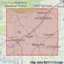
[Mapped north and west of Clarksville, TX, in Red River, Lamar, Delta, and Fanin Cos., northeastern TX; in a few places in Little River and Sevier Cos., southwestern AR; and from Foreman, Little River Co., AR, westward into McCurtain Co., southeastern OK.]
Source: Publication.

- Usage in publication:
-
- Ozan Formation
- Modifications:
-
- Mapped 1:250k
- Dominant lithology:
-
- Clay
- AAPG geologic province:
-
- East Texas Basin
- Ouachita folded belt
Summary:
Ozan Formation ("lower Taylor marl"). Clay, marly, calcareous content decreases upward, montmorillonitic, some glauconite, phosphate pellets, and hematite and pyrite nodules, variable amounts of silt-size quartz and calcite fragments become more abundant upward, blocky with conchoidal fracture, light gray to brown; weathers light gray to grayish orange and white, develops poor fissility. Thickness 500 to 775 feet. Grades upward to Wolfe City Formation. Lies above Austin Chalk. Age is Late Cretaceous.
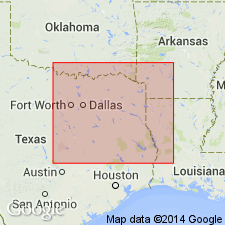
Mapped in Bell, Falls, Hill, McLennan, and Navarro Cos., eastern TX.
Source: Publication.
- Usage in publication:
-
- Ozan Formation*
- Modifications:
-
- Paleomagnetics
- AAPG geologic province:
-
- Arkla basin
Summary:
Paleomagnetic (a.f. demagnetized) data indicates the Upper Cretaceous Ozan Formation in the Arkla basin in southwest AR possesses a weak remanent magnetization of normal magnetic polarity. The normal polarity is assumed to be primary magnetization, and is interpreted to represent deposition during the Gubbio (Italy) normal polarity zone B+ (Campanian to early Maestrichtian).
Source: GNU records (USGS DDS-6; Denver GNULEX).

- Usage in publication:
-
- Ozan Formation
- Modifications:
-
- Mapped 1:250k
- Dominant lithology:
-
- Clay
- Silt
- Sand
- Limestone
- AAPG geologic province:
-
- East Texas basin
- Ouachita folded belt
Summary:
Ozan Formation ("lower Taylor marl"). Clay, calcareous, silt and sand content increases upward, montmorillonitic, blocky, conchoidal fracture, medium gray; some glauconite, phosphate pellets, hematite nodules, and pyrite nodules; some very thin limestone lenses locally in lower part; weathers light brownish gray with poor fissility, grades upward to Wolfe City Formation. Thickness 500+/- feet. Lies above Austin Chalk and below Wolfe City Formation. Marine megafossils. Age is Late Cretaceous.
[Mapped in Collin, Dallas, Ellis, Hill, Kaufman, Navarro, and Rockwall Cos., eastern TX.]
Source: Publication.

- Usage in publication:
-
- Ozan Formation
- Modifications:
-
- Mapped 1:250k
- Dominant lithology:
-
- Clay
- AAPG geologic province:
-
- East Texas basin
- Ouachita folded belt
- South Oklahoma folded belt
Summary:
Pamphlet [p. 2]. Ozan Formation. Clay, dark-gray, weathers to light-brownish-gray with weak fissility, calcareous, poorly bedded, variable amounts of silt and glauconite, some siltstone beds, marine megafossils. Thickness approximately 425 feet. Lies below Wolfe City Sand and above Austin Chalk. Age is Late Cretaceous.
[Mapped in mostly continuous belt in southeastern part of map sheet, in Collin, Fannin, and Hunt Cos., northeastern TX.]
Source: Publication.
For more information, please contact Nancy Stamm, Geologic Names Committee Secretary.
Asterisk (*) indicates published by U.S. Geological Survey authors.
"No current usage" (†) implies that a name has been abandoned or has fallen into disuse. Former usage and, if known, replacement name given in parentheses ( ).
Slash (/) indicates name conflicts with nomenclatural guidelines (CSN, 1933; ACSN, 1961, 1970; NACSN, 1983, 2005, 2021). May be explained within brackets ([ ]).