The National Geologic Map Database is migrating to a new infrastructure. We apologize for any service disruptions during this process.
|
|---|


- Usage in publication:
-
- Olentangy Shale
- Modifications:
-
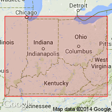
- Areal extent
- Overview
- Dominant lithology:
-
- Shale
- AAPG geologic province:
-
- Appalachian basin
Summary:
Olentangy Shale consists of a lower and an upper member, which correlate with the Blocher and Selmier of IN and KY, the lower and upper Dowelltown of TN, the Genesee and Sonyea of NY, and the Harrell and Brallier of the Appalachians. Olentangy is missing in northern OH, MI, southern Ontario, and western TN. "The Olentangy Shale [and its correlatives] extends in outcrop from Delaware Co., central OH, to southern OH, on all sides of the Cincinnati Arch in KY, southern and north-central IN, northern and eastern Highland Rims of TN, and Tishomingo Co., MS."
Source: GNU records (USGS DDS-6; Reston GNULEX).

- Usage in publication:
-
- Olentangy Shale Member
- Modifications:
-
- Revised
- AAPG geologic province:
-
- Appalachian basin
Summary:
In this study, the Chattanooga Shale is divided into (ascending) Rhinestreet Shale, Upper Olentangy Shale, Ohio Shale, Bedford Shale, Berea Sandstone, and Sunbury Shale Members. The Chattanooga thins westward. Geophysical logs indicate that in the western region, unit consists of only the Sunbury, Berea-Bedford, and Ohio Members, the Rhinestreet and Olentangy having pinched out. [No mention is made of a lower Olentangy in this report. Usage of "Upper Olentangy Shale Member" is not recommended.] According to the author, formal nomenclature presented in this report has been accepted by the Kentucky Stratigraphic Nomenclature Committee. Report includes correlation charts, cross-sections, and measured sections.
Source: GNU records (USGS DDS-6; Reston GNULEX).

- Usage in publication:
-
- Olentangy Shale*
- Modifications:
-
- Overview
- AAPG geologic province:
-
- Appalachian basin
Summary:
In central OH and northern KY, the Olentangy consists of a lower gray shale, and an upper greenish gray shale. Unit is generally less than 50 ft thick. It can only be identified with certainty in the subsurface a few mi east of its outcrop. At the western edge of the Pipe Creek Shale Member of the Java Formation, authors definitely drop the usage of the Olentangy. The upper greenish-gray shale is of Late Devonian age and appears to be the combined Angola Shale Member of the West Falls Formation and the Hanover Shale Member of the Java Formation based on the abundant calcareous nodules and scattered thin beds of black shale in both.
Source: GNU records (USGS DDS-6; Reston GNULEX).
For more information, please contact Nancy Stamm, Geologic Names Committee Secretary.
Asterisk (*) indicates published by U.S. Geological Survey authors.
"No current usage" (†) implies that a name has been abandoned or has fallen into disuse. Former usage and, if known, replacement name given in parentheses ( ).
Slash (/) indicates name conflicts with nomenclatural guidelines (CSN, 1933; ACSN, 1961, 1970; NACSN, 1983, 2005, 2021). May be explained within brackets ([ ]).