

- Usage in publication:
-
- Ogallala formation*
- Modifications:
-
- Original reference
- Dominant lithology:
-
- Grit
- Limestone
- Clay
- Sand
- Conglomerate
- AAPG geologic province:
-
- Denver basin
- Chadron arch
Summary:
Pg. 732-742. Ogallala formation. Calcareous grit or soft limestone, sandy clay, and sand, with basal conglomerate at many places. Of late Tertiary (Pliocene?) age. Thickness 150 to 300 feet. Unconformably underlies EQUUS beds and unconformably overlies Arikaree formation. Extends from Kansas and Colorado far into Nebraska. Is a part, if not the whole, of the deposit which in Kansas and southward has been called "Mortar beds," "Tertiary grit," and other names. Is upper part of Loup Fork beds, the lower part of Loup Fork being Arikaree formation.
[Named from exposures around Ogallala (correct spelling), Keith Co., NE.]
Source: US geologic names lexicon (USGS Bull. 896, p. 1531-1532).
- Usage in publication:
-
- Ogalalla [Ogallala] formation*
- Modifications:
-
- [Principal reference]
- Revised
- AAPG geologic province:
-
- Anadarko basin
Summary:
Ogalalla [Ogallala] fm. Thick sheet of sand and gravel (chiefly sand), late Tert. age; occupies most of highlands of both quads; extends across Haskell, Grant, and Stanton Cos. Surface considerably eroded, but base is not cut through except by Bear Creek, W. of Johnson. Thickness 180 to 300+ ft. Is believed to be a strat. unit and to be continuous from type loc. near [Ogallala] Station, west NE. Hay supposed the deposits were 2 fms. "Plains marl" at top and "mortar beds" below, but later studies by Haworth and others showed these apparent div. are local features and that generally fine-grained sediments alternate with the coarser "mortar beds" at dif. horizons. It is possible the 300+ ft. of beds that constitute [Ogallala] fm. comprise deposits elsewhere separable, even incl. locally in their upper part a representative of McPherson fm. ("EQUUS beds"). Apparently no separation is practicable in this region. Orig. the entire fm. was known as "Loup Fork beds," but this term also incl. Arikaree fm., which is older than the [Ogallala] and apparently does not extend into KS. No fossils in or near these quads., but many bones have been found in the [Ogallala] area elsewhere in NE and north KS. They range in age from very late Mio. to early Pleist., indicating a longer range in time than would appear to have been req. for the continuous deposition of the [Ogallala]. Most of material appears to have been laid down rapidly by streams, although the fine-grained strata req. considerable time for accumulation. It is believed Pleist. age bones found in some places are in local deposits of later age that overlie true [Ogallala], which appears more likely to have been laid down in Plio. and late Mio. time. In valleys and places on uplands the [Ogallala] grades up into fine sands and silts, which appear to have been carried and deposited by wind at var. times from Tert. to very recent. In part these are Plains marl of Hay, and fossils found in them are Recent.
Source: Modified from US geologic names lexicon (USGS Bull. 896, p. 1530-1532).
- Usage in publication:
-
- Ogallala formation
- Modifications:
-
- Revised
- AAPG geologic province:
-
- Anadarko basin
Summary:
Ogallala fm. here restricted to beds beneath "Plains marl." In Wallace Co., KS, the Ogallala rests uncon. on Pierre sh. and is uncon. overlain by Pleist. loess here named Sanborn fm. Is usually buff-colored to pinkish and chiefly unsorted sand and gravel, usually mixed in var. proportions with fine dust (loess-like fine sand or silt), which makes the rocks of the fm. rough to the touch. In some areas fine unctuous clays of light-green and reddish-brown colors constitute important beds in lower pt. of fm., and in middle and, especially uppermost pts., lenses of white and pinkish ls. occur. Beds of gravel and light-gray or greenish sorted sand, some cross-bedded, occur in places. Name Sanborn fm. proposed for the Pleist. loess, with some gravel and sand at base, that is widely distributed on divides in west KS, and is intended as substitute for old terms "Tertiary marl" or "Plains marl" of Hay. "As far as present experience indicates BIORBA RUGOSA fruits are the most valuable index fossil of the Ogallala in the restricted sense." Fossils found in middle pt. of typical "mortar beds" of Wallace Co. are lower Plio. No identified bones were collected near base or near top of Ogallala in Wallace Co., but unbroken continuity of fm., which is composed largely of coarse material and is only about 200 ft. thick, suggests possible completion of its sedimentation within lower Plio. One mi. W, and also SW of Guy Woodhouse Ranch bentonitic clays of bright mottled colors are exposed, which writer named Woodhouse clays. These clays are local lateral change in lith. of lower half of Ogallala fm. The prelim. exam. by H.T. Martin of vert. remains from Woodhouse clays showed decisively they may belong to either Mio or lower Plio., or to age of Ogallala fm. of Wallace Co. [See also under Woodhouse clay and Rhinoceros Hill beds. Elias has visited Ogallala, NE, and presents his interpretation of where base of Ogallala fm. should be drawn.]
Source: Modified from US geologic names lexicon (USGS Bull. 896, p. 1530-1532).
- Usage in publication:
-
- Ogallala formation
- Modifications:
-
- Biostratigraphic dating
- AAPG geologic province:
-
- Chadron arch
Summary:
Pg. 43 (footnote), 44. Assigned Ogallala to Pliocene and upper Miocene.
Source: US geologic names lexicon (USGS Bull. 896, p. 1530-1532).
- Usage in publication:
-
- Ogallala formation
- Modifications:
-
- [Principal reference]
- Biostratigraphic dating
- AAPG geologic province:
-
- Chadron arch
Hesse, C.J., 1935, A vertebrate fauna from the type locality of the Ogallala formation: University of Kansas Bulletin, v. 22, no. 5, p. 79-117.
Summary:
Ogallala formation. Described and figured vertebrate fauna from Feldt Ranch, Nebraska, where he stated is type locality of Ogallala formation. He assigned the fossils collected to Miocene, Pliocene, and Pleistocene, but stated the latter are not regarded as belonging to the Ogallala. "So far as I am able to determine there is no satisfactory indication that the Ogallala should be subdivided."
Type locality stated to be on Feldt Ranch, in SE/4 sec. 33, T. 14 N., R. 38 W., 2 mi east and 0.5 mi north of town of Ogallala, [Ogallala 7.5-min quadrangle], Keith Co., western NE.
Source: Publication; US geologic names lexicon (USGS Bull. 896, p. 1530-1532).

- Usage in publication:
-
- Ogallala formation*
- Ogalalla formation
- Modifications:
-
- Overview
Summary:
Ogallala formation. [Misspelled Ogalalla in some reports.] Recognized in western Nebraska, northeastern Colorado, southeastern Wyoming, southern South Dakota (?), western and central Kansas, western Oklahoma, northwestern Texas, and eastern New Mexico. Age is late Miocene and Pliocene.
See also under Arikaree formation.
Named from exposures around Ogallala (correct spelling), Keith Co., western NE.
Source: US geologic names lexicon (USGS Bull. 896, p. 1530-1532).
- Usage in publication:
-
- Ogallala formation
- Modifications:
-
- Revised
- AAPG geologic province:
-
- Chadron arch
Summary:
Pg. 467-473. Ogallala formation. Divisible into "cap rock bed," Burge sands, and Valentine beds. [Age is Pliocene.]
Source: US geologic names lexicon (USGS Bull. 1200, p. 2803-2804).
- Usage in publication:
-
- Ogallala group
- Modifications:
-
- Revised
- AAPG geologic province:
-
- Chadron arch
Summary:
Pg. 220-227. Ogallala group. In Nebraska comprises (ascending) Valentine formation, 175 to 225 feet; Ash Hollow formation, 100 to 250 feet; Sydney gravel, 15 to 50 feet; Kimball formation (new), 30 to 40 feet. Unconformably overlies Hemingford group (new). Age is Pliocene.
Source: US geologic names lexicon (USGS Bull. 1200, p. 2803-2804).
- Usage in publication:
-
- Ogallala
- Modifications:
-
- Areal extent
- AAPG geologic province:
-
- Anadarko basin
Smith, H.T.U., 1940, Geological studies in southwest Kansas: Kansas Geological Survey Bulletin, no. 34, 240 p.
Summary:
Pg. 39-94. [Ogallala formation.] Unit herein named Rexroad has been mapped as Ogallala, and some beds are indistinguishable from Ogallala. [Age is Pliocene.]
Source: US geologic names lexicon (USGS Bull. 1200, p. 2803-2804).
- Usage in publication:
-
- Ogallala formation
- Modifications:
-
- Revised
- AAPG geologic province:
-
- Anadarko basin
Summary:
Pg. 404-410. Ogallala formation is 60 to 375 feet thick in Meade basin. Overlies Laverne formation; underlies Meade formation. Middle Pliocene. Beds called Rexroad by Smith (1940) are herein designated Rexroad member of Ogallala.
Source: US geologic names lexicon (USGS Bull. 1200, p. 2803-2804).

- Usage in publication:
-
- Ogallala formation
- Modifications:
-
- Overview
Summary:
Pg. 20. Ogallala formation. In Kansas, comprises (ascending) Valentine, Ash Hollow, and Kimball members. Maximum thickness 350 feet. Overlies Pierre shale; underlies Meade formation in some areas and in others Sanborn formation. [Age is Pliocene.]
Source: US geologic names lexicon (USGS Bull. 1200, p. 2803-2804).
- Usage in publication:
-
- Ogallala formation
- Modifications:
-
- Overview
- AAPG geologic province:
-
- Anadarko basin
- Central Kansas uplift
- Chadron arch
- Las Animas arch
- Salina basin
Summary:
Ogallala formation. Sediments deposited by streams flowing eastward from Rocky Mountains in broad, relatively shallow erosional valleys cut in Cretaceous bedrock. In northern Kansas, subdivided into (descending) Kimball member, calcareous feldspathic sandy silt capped by a massive to nodular sandy and silty calcium carbonate zone; Ash Hollow member, gray to brown feldspathic sand, silt, gravel, contains soft limestone, numerous lentils of volcanic ash; and Valentine member, gray feldspathic sand. [See also entries under individual members.] Thickness up to 300+ feet. Unconformably overlies Cretaceous Pierre shale or Niobrara formation. Fossils. Age is late Tertiary (Miocene and Pliocene).
Source: Publication.
- Usage in publication:
-
- Ogallala formation
Summary:
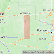
Pg. 7-20; J.C. Frye and A.B. Leonard, 1959, Corr. Ogallala Fm. (Neogene) in western TX with type locs. in NE, Univ. Texas Bur. Econ. Geol. Rpt. Inv., no. 39, 46 p. Ogallala formation. In Texas High Plains, Armstrong and Howard Counties, Pliocene Ogallala formation consists of fluviatile deposits, predominantly of sand but with some silt and local lenses of coarse gravel, resting on erosional topography with several hundred feet of relief, developed on bedrock. Distinctive fossil seeds permit correlation of floral zones as far south as Howard County with subdivisions (Valentine, Ash Hollow, and Kimball) recognized to north in Kansas and Nebraska. Formation becomes thin and discontinuous to south where upland surface of High Plains merges with Edwards Plateau, broken by remnants of still higher surface developed on Cretaceous limestones. Formation is distinguished at top by complex "Caprock" limestone. Unconformably underlies Blanco formation. Neogene.
Source: US geologic names lexicon (USGS Bull. 1200, p. 2803-2804).
- Usage in publication:
-
- Ogallala Formation*
- Modifications:
-
- Areal extent
- AAPG geologic province:
-
- Wind River basin
Summary:
Pg. A71. Ogallala Formation. In Granite Mountains area, [Fremont and Natrona Counties], central Wyoming, rocks previously included by Love (1961) in lower part of Moonstone Formation (areally restricted) and upper part of †Split Rock Formation (abandoned) are reallocated to Ogallala Formation. Correlative with South Pass Formation. Lies above Arikaree Formation. Age changed from Pliocene --to-- late Miocene and Pliocene (see Denson and others, p. A29, this volume).
Source: Publication.
- Usage in publication:
-
- Ogallala Formation
- Modifications:
-
- Mapped 1:250k
- Dominant lithology:
-
- Sand
- Silt
- Clay
- Gravel
- Caliche
- Conglomerate
- AAPG geologic province:
-
- Permian basin
Summary:
Pamphlet [p. 3]. Ogallala Formation. Fluviatile sand, silt, clay, and gravel capped by caliche. Sand, fine- to medium-grained quartz, in part silty and calcareous, clay balls common, clayey in upper part, indistinctly bedded to massive, cross-bedded, unconsolidated to weakly cohesive, local quartzite lenses, various shades of gray, red. Silt and clay with caliche nodules, reddish brown, dusky red, pink. Gravel, not everywhere present, mostly quartz, some quartzite, sandstone, limestone, chert, igneous rock, metamorphic rock, and worn GRYPHAEA in intraformational channel deposits and in basal conglomerate. Caliche, sandy, pisolitic at top, hard, produces caprock along Mescalero Ridge, New Mexico, may have formed since the Pliocene. Fossil plants and vertebrates scarce. Maximum thickness up to 100 feet. Lies above Lower Cretaceous Fort Terrett Formation and Fredericksburg Group, undivided, and below Pleistocene windblown cover sand [Blackwater Draw Formation] or Tahoka Formation. Age is late Tertiary (Pliocene).
[Largest exposures (sand and gravel facies) west of NM-TX State bdry., in Eddy and Lea Cos., southeastern NM; western half of map sheet. In Texas, eastern half of map sheet, sand facies mapped along creeks and draws, and around lakes. Ogallala tentatively mapped to south on Pecos quadrangle, scale 1:250,000.]
Source: Publication.
- Usage in publication:
-
- Ogallala Formation
- Modifications:
-
- Mapped 1:250k
- Dominant lithology:
-
- Sand
- Caliche
- Gravel
- AAPG geologic province:
-
- Amarillo arch
- Palo Duro basin
- Sierra Grande uplift
Summary:
Ogallala Formation. Sand, silt, clay, gravel, and caliche. Sand, fine-grained to coarse-grained quartz, silty in part, caliche nodules locally, cemented locally by calcite and by silica, locally cross-bedded, various shales of gray, brown, and red. Minor silt and clay with caliche nodules, sandy in places, massive, white, gray, olive-green, brown, red, and maroon. Gravel, not everywhere present, composed of pebbles and cobbles of quartz, quartzite, minor chert, igneous rock, metamorphic rock, and clay balls in lower part. Caliche, not everywhere present, sandy, pisolitic, white, gray, pink, may include some caliche of Pleistocene age. Thickness up to about 400 feet. Lies above Pliocene Raton Basalt and below Pleistocene and Pliocene gravel deposits and Pleistocene Rita Blanca deposits. Age is late Tertiary (Pliocene).
[Widely exposed throughout map sheet; btw. Amarillo, northwestern Texas Panhandle and Santa Fe, northwestern New Mexico.]
Source: Publication.

- Usage in publication:
-
- Ogallala Formation
- Modifications:
-
- Mapped 1:250k
- Dominant lithology:
-
- Sand
- Silt
- Clay
- Gravel
- Caliche
- AAPG geologic province:
-
- Palo Duro basin
- Permian basin
Summary:
Ogallala Formation. Fluviatile sand, silt, clay, and gravel capped by caliche. Sand, fine- to medium-grained quartz, in part silty and calcareous, clayey in upper part, clay balls, indistinctly bedded to massive, cross-bedded, unconsolidated to weakly cohesive, local quartzite lenses, various shades of gray and red. Silt and clay with caliche nodules, reddish-brown, dusky red, pink. Gravel, not everywhere present, mostly quartz, some quartzite, sandstone, limestone, chert, igneous rock, metamorphic rock, and worn GRYPHAEA in intraformational channel deposits and in basal conglomerate. Caliche, sandy, pisolitic at top, hard, forms caprock. Fossil plants and vertebrates scarce. Includes Bridwell and Couch Members, not separately mapped. Maximum thickness 250 feet. Lies above Lower Cretaceous Duck Creek and Kiamichi Shales and below Pliocene Blanco Formation. Age is late Tertiary (Miocene and Pliocene).
[Mapped in mostly continuous belt along the Caprock Escarpment, as well as along stream drainages on the Llano Estacado, in Crosby, Dickens, Floyd, Garza, Hale, Lubbock, Lynn, and Motley Cos., TX.]
Source: Publication.
- Usage in publication:
-
- Ogallala Group*
- Modifications:
-
- Mapped 1:250k
- Dominant lithology:
-
- Sand
- Gravel
- Sandstone
- Siltstone
- Conglomerate
- AAPG geologic province:
-
- Chadron arch
- Denver basin
Summary:
Ogallala Group. Principally fluvial deposits locally subdivided into (not separately mapped, descending): (1) informal Angora sand and gravel beds of Swinehart and Diffendal, 1995 (USGS Misc. Inv. Ser. Map I-2496, Geol. Morrill County, scale 1:62,500), grayish-pink sand and gravel and interbeds of silt and diatomite, commonly 80 to 100 feet thick, late Miocene (provisionally Hemphillian NALMA) age; (2) Ash Hollow Formation, late Miocene (Clarendonian and Hemphillian NALMA) age; and (3) informal Duer Ranch beds of Swinehart and Diffendal, 1987 (GSA Centennial Field Guide, North-Central Sec., v. 3, p. 23-28, Duer Ranch, Morrill County), brown silty sandstone with lesser amounts of siltstone and conglomerate, up to 100+/- feet thick, middle Miocene (early Clarendonian NALMA) age. Lies above upper Oligocene to lower Miocene Arikaree Group and below Pliocene Broadwater Formation.
Source: Publication.
- Usage in publication:
-
- Ogallala Group
- Modifications:
-
- Biostratigraphic dating
- Geochronologic dating
Tedford, R.H., Albright, L.B., III, Barnosky, A.D., Ferrusquia-Villafranca, Ismael, Hunt, R.M., Jr., Storer, J.E., Swisher, C.C., III, Voorhies, M.R., Webb, S.D., and Whistler, D.P., 2004, Mammalian biochronology of the Arikareean through Hemphillian interval (late Oligocene through early Pliocene epochs): Columbia University Press, p. 167-231.
Summary:
Chart (fig. 6.2). Ogallala Group. [Recognized chiefly in Nebraska, northern Great Plains. Age is Miocene to earliest Pliocene (Hemingfordian to Hemphillian NALMA). Several named vertebrate faunas listed. Comprises (in descending order):
unnamed uppermost beds containing Santee ash, 5.0 +/-0.2 Ma (Boelstorff, 1978, Nebraska Acad. Sci. Trans., v. 6, p. 35-49) and latest Hemphillian (Hh4) Santee local fauna;
Ash Hollow Formation, middle Clarendonian to early late Hemphillian (Cl2 to Hh3);
Valentine Formation, late Barstovian to early Clarendonian (Ba2 to Cl1);
Olcott Formation and equivalent Sand Canyon beds [informal], early Barstovian (Ba1);
Sheep Creek Formation, late late Hemingfordian (He2);
Split Rock Formation and equivalent Box Butte Formation, early late Hemingfordian (He2);
basal Runningwater Formation, early Hemingfordian (He1).]
Source: Publication.
For more information, please contact Nancy Stamm, Geologic Names Committee Secretary.
Asterisk (*) indicates published by U.S. Geological Survey authors.
"No current usage" (†) implies that a name has been abandoned or has fallen into disuse. Former usage and, if known, replacement name given in parentheses ( ).
Slash (/) indicates name conflicts with nomenclatural guidelines (CSN, 1933; ACSN, 1961, 1970; NACSN, 1983, 2005, 2021). May be explained within brackets ([ ]).