

- Usage in publication:
-
- Minisink Limestone*
- Modifications:
-
- Named
- Dominant lithology:
-
- Limestone
- AAPG geologic province:
-
- Appalachian basin
Summary:
Pg. 2 (fig. 1), 34-35, 36 (fig. 11), 55-57, 65-67, pl. 1. Minisink Limestone of Helderberg Group. Thin argillaceous limestone between shales of New Scotland Formation and Port Ewen Shale in eastern Pennsylvania and New Jersey has in past been assigned, with some uncertainty, to Becraft Limestone. However, inasmuch as type Becraft of New York consists of "very coarse-grained, crinoidal, dark-gray or pink limestone containing such an abundance of fossils in places that it may be classified as a shellrock or coquinite" (Rickard, 1962, New York State Mus. Bull., no. 386, p. 88) and its stratigraphic relations to the limestone interval between the New Scotland and Port Ewen Formations in the Pennsylvania-New Jersey area are unknown, name Minisink Limestone is proposed for these beds. Consists of dark- to medium-gray, fine-grained, light-gray weathering, argillaceous limestone in beds from a few inches to about 3 feet thick; lenses of purer limestone occur in reference section (Lake Maskenozha quadrangle). Generally not well exposed. Thickness is 14 feet at type section, 11.5 feet at reference section. Member persists to southwest near Bossardsville, Pennsylvania, and as far northeast as Trilobite Mountain, New York, where it is 20 feet thick. Overlies Maskenozha Member (new) of New Scotland Formation; contact is abrupt or gradational and is characterized by change from shale having some argillaceous limestone beds in the Maskenozha to argillaceous limestone in the Minisink. Abruptly underlies Port Ewen Shale. Position of Minisink suggests that it is equivalent to the Becraft and (or) Alsen Formations of New York. However, it may be stratigraphically lower than either the Becraft or Alsen. If it is, the New Scotland and Port Ewen are not exact equivalents between the two areas. Rather than introduce new names for these formations, names New Scotland and Port Ewen are retained in this report. The Minisink is moderately fossiliferous; contains brachiopods, bryozoans, corals, and crinoid columnals. Age is Early Devonian. Report includes measured sections. (Minisink Limestone of Helderberg Group adopted by the USGS.)
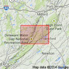
Type section: in roadcut on southwest side of U.S. Interstate Highway I-80, about 0.4 mi southwest of Minisink Hills, in northeast corner of Stroudsburg quadrangle [approx. Lat. 40 deg. 59.8 min. N., Long. 75 deg. 8.9 min. W., Monroe, Co., PA (A.G. Harris, written commun., ca. 1995)]. Minisink is completely exposed, although upper and lower contacts tend to become covered with shale. Section lies along overturned asymmetrical syncline. Named from village of Minisink Hills.
Reference section (=type section for Maskenozha and Flatbrookville Members of New Scotland Formation): about 3.5 mi northeast of Flatbrookville, in woods and along northeast side of Flatbrookville-Wallpack Center Road, 3.2 mi (road distance) from intersection with Trans-Kittatinny Road joining it from the southeast, near southern edge of Lake Maskenozha 7.5-min quadrangle [approx. Lat. 41 deg. 7.7 min. N., Long. 74 deg. 54.86 min. W., Sussex Co., NJ (A.G. Harris, written commun., ca. 1995)].
Source: Publication; US geologic names lexicon (USGS Bull. 1350, p. 492-493); GNU records (USGS DDS-6; Reston GNULEX); Changes in stratigraphic nomenclature, 1967 (USGS Bull. 1274-A, p. A13).
- Usage in publication:
-
- Minisink Limestone
- Modifications:
-
- Overview
- AAPG geologic province:
-
- Appalachian basin
Summary:
Minisink Limestone and New Scotland Formation of Helderberg Group are mapped undivided in northwestern NJ, but are discussed separately in the text. Minisink is a medium-gray, fine-grained argillaceous limestone, medium-bedded, with some nodules and lenses of a more calcium-rich limestone. Maintains a uniform thickness of 20 ft. Lower contact with New Scotland is covered but is gradational elsewhere in the region. Underlies Port Ewen Shale of Helderberg Group. Age is Early Devonian.
Source: GNU records (USGS DDS-6; Reston GNULEX).
For more information, please contact Nancy Stamm, Geologic Names Committee Secretary.
Asterisk (*) indicates published by U.S. Geological Survey authors.
"No current usage" (†) implies that a name has been abandoned or has fallen into disuse. Former usage and, if known, replacement name given in parentheses ( ).
Slash (/) indicates name conflicts with nomenclatural guidelines (CSN, 1933; ACSN, 1961, 1970; NACSN, 1983, 2005, 2021). May be explained within brackets ([ ]).