

- Usage in publication:
-
- Maquoketa shale
- Modifications:
-
- Named
- Dominant lithology:
-
- Shale
- AAPG geologic province:
-
- Iowa shelf
Summary:
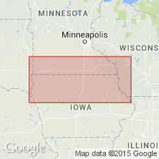
Name applied to a series of bluish and brownish shales. The shales can be slightly arenaceous; some with calcareous bands; are sometimes bituminous. The most southerly exposure is in bluffs of Mississippi River near Bellvue, Jackson County, Iowa. The most northerly exposure is in western Winnishiek County, Iowa. Overlies Galena limestone of Trenton group. Underlies Niagara limestone of Niagara group. Graphic section. Fossils (listed): cephalopods, graptolites, etc. Age is Late Silurian (Cincinnati age).
[GNU records state "type not designated", yet "typically developed on the Little Maquoketa River 12 mi west from Dubuque, Dubuque Co., IA on the Iowa shelf."]
Source: Modified from GNU records (USGS DDS-6; Denver GNULEX).

- Usage in publication:
-
- Maquoketa Shale Group
- Modifications:
-
- Overview
- AAPG geologic province:
-
- Illinois basin
Summary:
Used as Cincinnatian (Richmondian) Maquoketa Shale Group in IL. Consists of Scales Shale (and its Elgin Shale Member, Clermont Shale Member, Thebes Sandstone Member, and Orchard Creek Shale Member), Fort Atkinson Limestone, Brainard Shale, Neda Formation, and Girardeau Limestone. Throughout most of IL, includes Scales, Fort Atkinson, and Brainard. In northern IL, Neda is present locally at top of Maquoketa. In extreme southwestern IL, only Scales is present. Maquoketa contains Lower Depauperate Zone (at base of Scales) and Upper Depauperate Zone (near top of Scales), characterized by distinctive pyritic and phosphatic beds and containing only small fossils (depauperate), mostly a coquina of mollusks. Maquoketa is equivalent to Collingswood and Queenston strata in Ontario and NY, to Sylvan Shale to the southwest, and to Reedsville Shale and Sequatchie Formation to the south and southeast of IL. Report includes geologic maps and correlation charts.
Source: GNU records (USGS DDS-6; Reston GNULEX).
- Usage in publication:
-
- Maquoketa Group
- Modifications:
-
- Age modified
- Revised
- AAPG geologic province:
-
- Ozark uplift
- Upper Mississippi embayment
Summary:
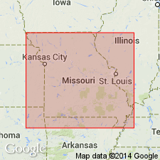
Ordovician (Cincinnatian) Maquoketa Group in Cape Girardeau Co., southeastern Missouri comprises four formations the lowest of which has never been formally named. Cape La Croix Shale is here proposed and assigned to the basal Maquoketa. Type and principal reference sections designated. Disconformably overlying the new Cape La Croix Shale is (ascending) Thebes Sandstone, Orchard Creek Shale, and Girardeau Limestone. The Maquoketa disconformably overlies Ordovician (Cincinnatian) Cape Limestone and underlies (with possible slight disconformity) Ordovician (Cincinnatian) Leemon Formation. Report includes stratigraphic columns, correlation and nomenclature charts, and type section maps.
Source: GNU records (USGS DDS-6; Reston GNULEX).

- Usage in publication:
-
- Maquoketa Shale*
- Modifications:
-
- Overview
- AAPG geologic province:
-
- Iowa shelf
Summary:
"Richmondian" fauna of Cincinnati Arch region is more similar to nautiloid faunas described from carbonate-rich facies of Maquoketa Shale in northeastern IA and adjacent MN. Age of Maquoketa is Late Ordovician (Cincinnatian, Maysvillian to Richmondian).
Source: GNU records (USGS DDS-6; Reston GNULEX).

- Usage in publication:
-
- Maquoketa Shale*
- Modifications:
-
- Overview
- AAPG geologic province:
-
- Illinois basin
- Ozark uplift
Summary:
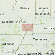
Maquoketa Shale is mapped in IL and in subsurface of MO. Occurs in all but southwestern one-third of quadrangle where it is cut out by regional unconformity at base of Upper Devonian rocks. Outcrops are restricted to area just north of Cape au Gres structure in IL.
Source: GNU records (USGS DDS-6; Reston GNULEX).
- Usage in publication:
-
- Maquoketa Formation*
- Modifications:
-
- Revised
- Overview
- AAPG geologic province:
-
- Illinois basin
- Ozark uplift
Summary:
Ordovician (Cincinnatian) Maquoketa Formation reduced in rank from Maquoketa Group because its smaller units are not mappable at scales of 1:24,000 or smaller. In most of the quad, Maquoketa consists of dark-gray to greenish-gray, partly silty and calcareous shale with thin limestone interbeds. Isopach maps (Sargent and Roemelle, 1990; Whitaker, 1988) show Maquoketa regionally thickening eastward from about 150 ft to more than 300 ft. Locally thickens in extreme western KY. In southwestern part of quad, divided into four members. Cape La Croix Shale Member at base is dark-gray marine shale containing thin interbeds of micritic limestone. Cape La Croix becomes silty near its top and grades into overlying Thebes Sandstone Member. Thebes is more than 100 ft thick in places and is composed of calcareous siltstone and very fine-grained, argillaceous sandstone, much of it intensely burrowed. Red and green variegated claystone occurs at the top of the Thebes in some places. Above Thebes is Orchard Creek Shale Member, which, like Cape La Croix, consists of dark-gray marine shale containing micritic limestone interbeds. Orchard Creek grades into overlying Girardeau Limestone Member. Eastward and northward into subsurface, Thebes and Girardeau grade to shale (Maquoketa Shale, undivided). Upper surface of Maquoketa is disconformable. Thin, discontinuous Leemon Formation (formerly mapped as Edgewood Formation) locally overlies Maquoketa near Cape Girardeau.
Source: GNU records (USGS DDS-6; Reston GNULEX).

- Usage in publication:
-
- Maquoketa Group*
- Modifications:
-
- Overview
- AAPG geologic province:
-
- Illinois basin
- Upper Mississippi embayment
Summary:
Cape La Croix Shale, Thebes Sandstone, and Orchard Creek Shale of Maquoketa Group mapped undivided in Illinois basin in IL and Upper Mississippi embayment in MO. Usage follows Thompson (1991). Girardeau Limestone of Maquoketa Group is mapped undivided with Leemon Formation in IL and MO.
Source: GNU records (USGS DDS-6; Reston GNULEX).
For more information, please contact Nancy Stamm, Geologic Names Committee Secretary.
Asterisk (*) indicates published by U.S. Geological Survey authors.
"No current usage" (†) implies that a name has been abandoned or has fallen into disuse. Former usage and, if known, replacement name given in parentheses ( ).
Slash (/) indicates name conflicts with nomenclatural guidelines (CSN, 1933; ACSN, 1961, 1970; NACSN, 1983, 2005, 2021). May be explained within brackets ([ ]).