The National Geologic Map Database is migrating to a new infrastructure. We apologize for any service disruptions during this process.
|
|---|


- Usage in publication:
-
- Lyons sandstone*
- Modifications:
-
- Original reference
- Dominant lithology:
-
- Sandstone
- AAPG geologic province:
-
- Denver basin
Summary:
Lyons sandstone. The rocks of Boulder region hitherto called "Wyoming" embrace 3 formations (descending) Lykins formation, Lyons sandstone, and Fountain formation. The Lykins formation is "Upper Wyoming" of previous reports. The "Lower Wyoming" here clearly embraces two lithological units. The lower and major part consists chiefly of rather coarse, arkose sandstones and conglomerates of reddish color, while the upper and lesser part is a finer-grained quartzose sandstone of white, "creamy", or light-reddish color. The coarse sandstones were called Fountain formation by Cross in Pikes Peak folio. The top of Fountain formation is not exposed in Pikes Peak quadrangle, but Darton (GSA Bull., v. 15, p. 22) has found the character of the Fountain as described by Cross to continue [upward] to a white sandstone, corresponding with "creamy sandstone" of Eldridge occurring in Garden of the Gods, to which name Lyons sandstone is here given. The Fountain is characterized by very thick beds throughout and cross-bedding may be found at any horizon. The Lyons sandstone consists of purely quartzose sandstone. It is best developed at Lyons (a few miles north of Boulder district as mapped), where it is quarried in large amounts. The siliceous cement of this sandstone has sufficient iron to produce shades of pink, but the popular name "creamy sandstones" conveys a wrong impression as to their color. While they have a fairly uniform shade they are locally almost white, and at some places red. These sands are characterized by cross-bedding of unusual dimensions, perfection, and dip, which is at a lower angle than that of the true bedding. This cross-bedded stratum reaches maximum thickness of 297 feet at Fourmile Canyon and is absent just south of Boulder Creek. It grades into underlying Fountain of "Red Beds," and is conformably overlain by Lykins formation. [Age is Permian.]
Source: US geologic names lexicon (USGS Bull. 896, p. 1242-1243).
- Usage in publication:
-
- Lyons sandstone
- Modifications:
-
- Areal extent
- AAPG geologic province:
-
- Denver basin
Summary:
Pg. 68, 75, etc. Applied Ingleside formation to 100 to 125 feet of beds underlying Lyons sandstone and overlying Fountain formation from north line of State to a little north of Lyons, [Larimer and Boulder Counties, Colorado]. [Age is Permian.]
[See under Ingleside formation.]
Source: US geologic names lexicon (USGS Bull. 896, p. 1242-1243).
- Usage in publication:
-
- Lyons sandstone*
- Modifications:
-
- Revised
- AAPG geologic province:
-
- Denver basin
Summary:
Lyons sandstone redefined. A hard ledge-making sandstone, 100 feet thick, characterized by conspicuous cross-bedding, occurs at Lyons, [Boulder County], Colorado, from which it takes its name. It differs in general appearance from all neighboring rocks. It is of light-red or pink color, consists almost wholly of coarse sand, contains a few small pebbles in some places near the base, and is separated by an inconspicuous erosional unconformity from the older rocks. The most conspicuous peculiarity of the sandstone is its cross-bedding. As originally defined by Fenneman some of the red sedimentary rocks here referred to Ingleside formation were included in Lyons sandstone, for the Lyons was said to rest on the Fountain. However, the original description applies chiefly to the cross-bedded upper part (popularly called "Creamy" sandstone because of its light color), which is the Lyons of present paper. The inclusion in the Lyons of sandstones here referred to Ingleside formation and the miscorrelation of these older sandstones with beds in upper part of the Fountain farther south have led to confusion, which is dispelled by following the formations at outcrop to points where both Lyons sandstone as here defined is traceable by its stratigraphic position and physical peculiarity southward beyond Eldorado, where it thins out. It was not found near Golden nor at Morrison. It is practically continuous northward to Boxelder Canyon, where it seems to thin out. No fossils except tracks of a reptile which C.W. Gilmore regards as Permian. The fossiliferous beds in basal part of overlying Lykins formation are regarded as probably Permian. Hence Lyons sandstone is here classified as Permian. [See also under Ingleside formation.]
Source: US geologic names lexicon (USGS Bull. 896, p. 1242-1243).
- Usage in publication:
-
- Lyons sandstone
- Modifications:
-
- Revised
- AAPG geologic province:
-
- Denver basin
Summary:
Lyons sandstone of Cassa group. Included in Cassa group (new). Underlies Opeche shale; overlies Owl Canyon formation (new). [Age is Permian.]
Source: US geologic names lexicon (USGS Bull. 1200, p. 2284-2285).

- Usage in publication:
-
- Lyons sandstone*
- Modifications:
-
- Areal extent
- AAPG geologic province:
-
- Las Animas arch
Summary:
Extended into the subsurface of Otero County, Colorado, on the Las Animas arch. Correlative in part with Cedar Hills sandstone of Oklahoma and Kansas. Overlies Fountain formation and underlies Lykins formation. Age is Permian. Report includes correlation chart.
Source: Modified from GNU records (USGS DDS-6; Denver GNULEX).
- Usage in publication:
-
- Lyons sandstone*
- Modifications:
-
- Areal extent
- AAPG geologic province:
-
- Denver basin
Summary:
Pg. 34. Lyons sandstone. Lies directly on Fountain formation south of Loveland but rests on younger and younger beds northward. Thickness 50 feet near Colorado-Wyoming boundary; approximately 200 feet at Morrison and Colorado Springs. Conformably underlies Lykins formation. [Age is Permian.]
Source: US geologic names lexicon (USGS Bull. 1200, p. 2284-2285).
- Usage in publication:
-
- Lyons sandstone*
- Modifications:
-
- Mapped 1:24k (Golden quad, Jefferson Co, CO)
- Dominant lithology:
-
- Sandstone
- Conglomerate
- Siltstone
- Mudstone
- AAPG geologic province:
-
- Denver basin
Summary:
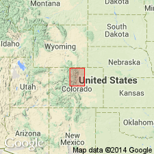
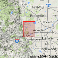
Is Permian formation mapped in northern Jefferson Co, CO (Denver basin). Outcrops as a narrow northwesterly striking band in southwestern part of quad where unit forms low hogback north of Tucker Gulch. South of Tucker Gulch it has been cut out by Golden fault. Unconformably? overlies Fountain formation (Pennsylvanian); unconformably? underlies Lykins formation (Permian? and Triassic?). Described as light-gray to grayish-orange, fine- to medium-grained, cross-bedded, quartzose sandstone, with some siltstone, mudstone, and conglomerate. Permian age based on fossil reptile tracks. Thickness is about 150 ft.
Source: GNU records (USGS DDS-6; Denver GNULEX).

- Usage in publication:
-
- Lyons sandstone*
- Modifications:
-
- Mapped 1:24k (Littleton quad, Arapahoe, Douglas, and Jefferson Cos, CO)
- Dominant lithology:
-
- Sandstone
- AAPG geologic province:
-
- Denver basin
Summary:
Is Permian formation mapped in east-central Jefferson Co, CO (Denver basin). Outcrops as hogback in southwestern portion of map. Map unit is fine-grained yellowish-gray to pale-red friable cross-bedded sandstone about 190 ft thick that is composed almost exclusively of clean well-sorted and well-rounded quartz grains. Sandstone extensively fractured near water gap in SE/4 sec 16, T6S, R69W. Cross-bedding suggests an eolian origin. Unconformably overlies Fountain formation (Pennsylvanian and Permian); conformably underlies Lykins formation.
Source: GNU records (USGS DDS-6; Denver GNULEX).
- Usage in publication:
-
- Lyons sandstone*
- Modifications:
-
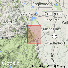
- Mapped 1:24k (Kassler quad, Douglas and Jefferson Cos, CO)
- Dominant lithology:
-
- Sandstone
- AAPG geologic province:
-
- Denver basin
Summary:
Is Permian formation mapped in northwestern Douglas and southeastern Jefferson Cos, CO (Denver basin). Outcrops as northwesterly striking, northeast dipping (60 deg) band along Hogback in central part of map. Unit is well-exposed forming continuous hogback. Described (p.89-90) as yellowish-gray to pale-red massive fine-grained cross-bedded quartzose friable sandstone. Top of unit marked by conglomerate and coarse-grained sandstone containing large flakes of muscovite. Measured section. Unconformably overlies Fountain formation (Pennsylvanian and Permian); conformably underlies Lykins formation (Permian? and Triassic?). Thickness is about 235 ft.
Source: GNU records (USGS DDS-6; Denver GNULEX).

- Usage in publication:
-
- Lyons Sandstone*
- Modifications:
-
- Mapped 1:24k (Morrison quad, Jefferson Co, CO)
- Dominant lithology:
-
- Conglomerate
- Sandstone
- AAPG geologic province:
-
- Denver basin
Summary:
Is Permian formation mapped in north-central Jefferson Co, CO (Denver basin). Outcrops along west side of Hogback. Unconformably overlies Fountain Formation (Permian and Pennsylvanian); conformably underlies undivided map unit of Bergen Shale, Falcon Limestone and Harriman Shale Members of LeRoy (1946) (Permian) of Lykins Formation. Described as yellowish-gray conglomerate composed of Precambrian detritus as large as 2 inches, which grades downward into yellowish-gray and yellowish-orange iron-stained fine-grained cross-stratified sandstone that also contains conglomerate a few feet above base. Thickness is about 190 ft.
Source: GNU records (USGS DDS-6; Denver GNULEX).
- Usage in publication:
-
- Lyons Sandstone*
- Modifications:
-
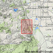
- Mapped 1:24k (Indian Hills quad, Jefferson Co, CO)
- Dominant lithology:
-
- Sandstone
- AAPG geologic province:
-
- Denver basin
Summary:
Is Permian formation mapped in central Jefferson Co, Co (Denver basin). Outcrops in east and northeast part of quad in a band along west side of Hogback. Conformably overlies Fountain Formation (Pennsylvanian and Permian); conformably underlies a 1 ft-thick informal unit named here as "limestone bed of the Ken Caryl Ranch" which occurs at base of Lykins Formation (Permian and Triassic?). Map unit described as yellowish-gray to pale-red moderately soft friable cross-bedded sandstone cemented by calcite and iron oxide. Contains iron-oxide nodules and fracture fillings. Softer and more easily eroded here than at Lyons, CO. Thickness about 190 ft.
Source: GNU records (USGS DDS-6; Denver GNULEX).
- Usage in publication:
-
- Lyons Sandstone*
- Modifications:
-
- Age modified
- AAPG geologic province:
-
- Denver basin
Summary:
Lyons Sandstone is of Roadian and Wordian, or Early Permian age, an age refinement, in the Colorado Front Range, Denver basin. Overlies Owl Canyon Formation.
Source: GNU records (USGS DDS-6; Denver GNULEX).
For more information, please contact Nancy Stamm, Geologic Names Committee Secretary.
Asterisk (*) indicates published by U.S. Geological Survey authors.
"No current usage" (†) implies that a name has been abandoned or has fallen into disuse. Former usage and, if known, replacement name given in parentheses ( ).
Slash (/) indicates name conflicts with nomenclatural guidelines (CSN, 1933; ACSN, 1961, 1970; NACSN, 1983, 2005, 2021). May be explained within brackets ([ ]).